 |
| Good boots, a map, and a navigation app are recommended |
Suggestions for those new to walking
The list of suggestions below is to help you enjoy our walks to the maximum. They cover what you should take, how to print the pages without using too much paper, and how you can share your own tips and comments after completing the walks.
- Locating the start point
- Public transport
- Parking
- Finding the right walk
- Total ascent of each walk
- Wheelchairs and pushchairs
- Walking groups
- Tree-friendly printing
- Take a map or app
- GPS navigation
- GPX download issues
- Komoot correct route
- Why Hertfordshire Walker doesn't have its own app
- Viewing web version on mobile
- How to bookmark 'favourite' walks
- Smartphone power issues
- Using GPS offline
- What3Words location references
- Getting lost
- Footpath names and numbers
- Hertfordshire's ROW map
- Compass points
- What to wear
- Keeping hydrated
- First aid
- Insects
- Livestock
- Shaded walks
- Pubs
- Closures
- Reporting faults
- Golf courses
- Flooding
- Treating boots
- Leave a comment
- Layers on maps
- Share on social media
Finding the start point
 |
| The What3Words references for the start of a walk |
- We usually add the road/lane/street name and village so that those with satellite navigation on their smartphones can pop the details into their device.
- We also add What3Words references to the start/finish points and at various important junctions mentioned along the way, see below for more details.
- If the walk starts at a pub we give the name of the pub and a link so that walkers can look it up and find the right address and check opening times.
Public transport
 |
| uno service 602 |
Parking
 |
| Car parks will be show with a blue icon and a white car |
We don't make recommendations for parking along roads because restrictions might be introduced after our visit.
Neither do we mention the roads where we have parked because they are often residential areas and we have had complaints in the past for suggesting people park in certain roads.
The best way to find a parking space is to use Google Street View (or similar) and check for possible parking spots before you set off (which is what we do).
Local pubs will often allow you to park in the car parks if you are taking refreshments before or after your walk - but please do check with the pubs concerned before using their car parks.
Finding the right walk
 |
| Finding the starting point for a walk |
- We have a list of all the walks and their lengths in the left-hand column of the website.
- There is also a page that lists all the walks on the site.
- There is a box in the left-hand column of the website where walks are grouped by their length and one where they are grouped by their total ascent.
- We have a page with two colour-coded interactive maps which you can find walks that are in the location you want to explore and are of a length and total ascent to match your walking ability.
- We have a page setting out a selection of flat walks, a page which lists shaded walks, and a page with linear walks - many of which are station-to-station for those who prefer to use public transport.
- There is a page that lists every pub and cafe mentioned on our walks, so you see which routes pass by.
- And you can use the search box at the top right of the website and enter the village or location you would like to visit.
Total ascent
 |
| Steps on Walk 57: Chapmore End Loop |
Total ascent measures all elevation increases during each walk. This is also known as 'elevation gain'.
You will see a 'total ascent' number alongside every walk. To help you work out what it means, a flight of stairs is about 3m, so a walk that has a total ascent of 60m is the equivalent of climbing to the top of a 20-storey building and walking back down again.
Some GPX tools use 'average ascent', which measures the average of all ascents during a walk, or 'maximum elevation', which is the highest elevation achieved.
But we think the most useful measurement for those planning our walks is to know how much they will have to walk uphill. That is why we use 'total ascent', or 'elevation gain'.
Total ascent measures all the ups in a walk. For example: If your house has 15 steps between floors. If you go up to the first floor you will have walked 15 steps. That is the maximum elevation. But if you walk up and down the steps 10 times during the day you would have walked 150 steps. This is the 'total ascent' or 'elevation gain'.
Walking apps sometimes choose different elevation measurements, such as 'average ascent', which offers an average of all ascents recorded during an activity or 'maximum elevation', which calculates the highest elevation achieved. But we are using 'total ascent', also known was 'elevation gain' so that you know the exact amount of walking uphill the walk involves.
Wheelchairs and pushchairs
The majority of our walks involve sections with narrow footpaths which are often overgrown with brambles and nettles. The routes also involve byways that can be muddy after rain and rock-hard and rutted during dry weather. All our walks cross undulating countryside. Most features stiles, narrow gates, steps, and footbridges.
As mentioned above, we have often been asked which walks would be suitable for wheelchairs and pushchairs. So we've created a page of flat routes that might be suitable for wheelchair and pushchair users.
There is also a linear section of Walk 80: Panshanger Park long loop would work if you went from the free car park and headed west from point 1 to points 16, 15, then keep heading west along the flat track to 9 before returning the same way (total of 2 miles).
Hertfordshire County Council's Rights of Way team has done a great job replacing old stiles and wooden gates with wider, aluminium gates, but there are still parts of the county‘s network of public footpaths, bridleways, and byways that would be difficult for those attempting the routes with a wheelchair or pushchair. Footbridges and stiles can fall into disrepair and become impassable and the council depends on walkers to alert them when a path is blocked or in need of work. You can also alert the council if you encounter a problem with the rights of way - see our section on reporting faults.
There is a national site that is building a database of routes suitable for wheelchair users.
Walking groups
 |
| There are many walking groups which welcome new members |
The list has been compiled from posts made in our Hertfordshire Walker members-only Facebook Group, which you are welcome to join. All the groups listed say they welcome new members.
Some might be free to join, others might charge a subscription - please check with the group you want to join.
Tree-friendly printing
If you want to print the walk directions without the pictures you can do so by using the PrintFriendly tool.
PrintFriendly allows you to delete any elements of the walk that you don't need
 |
If you are using the mobile version of the site you can get to the PrintFriendly icon by scrolling down to the bottom of the page then clicking on the 'view web version' link. That will then load the web version on your phone.
You then scroll to the bottom of the page where you will find the green PrintFriendly printer icon under the interactive map.
If you click on it the page will load in PrintFriendly allowing you to delete any elements you don't need before printing.
Alternatively you can change the settings on your browser by clicking on the three vertical buttons to reveal a menu then checking the 'Desktop site' option.
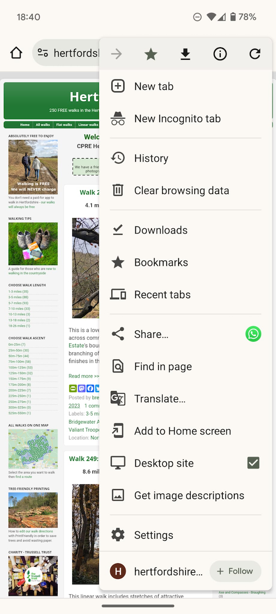 |
| Changing from mobile to desktop versions |
Back up map
 |
| You might want to carry an Ordnance Survey map to check routes |
GPS navigation
 |
| Our walks can be downloaded free-of-charge to mobile devices |
The first is by using GPS. It's a bit like using a sat nav in a car. The route will be transferred to a map and your position will be shown with a marker which will move as you move. It will also prompt you when you are straying away from the route, so you are less likely to get lost.
We offer free GPS downloads for all our routes. Simply pick the walk you want, open it, scroll down to the static map under the walk's 'Directions', then click on the GPX file to start the download.
Once the file GPX file is downloaded to your device you can open it using your preferred GPS tracker. We test all our walks on three free GPS apps. We use Komoot, GPS Viewer, and OsmAnd. We also subscribe to the paid-for Ordnance Survey (OS) app because I like to see the extra details so I can add information when I am writing the directions for the walks. We have a page setting out how to download and follow our sat nav routes.
Ordnance Survey app
In early 2022 we encountered an intermittent problem downloading GPX files to the paid-for OS app. I have found a work around.
- Download and save the GPX file for the walk to your desktop computer
- Open the OS page on your desktop device
- Open the GPX file for the walk on the OS desktop version
- You will see it opens fine
- Save the walk on the desktop device
- Go to your mobile device
- Open the OS app and log in to your account
- Find the walk on your OS app
- Open it and you will find it works.
If the OS app fails to load a GPX file, please try the free Komoot, which works everytime.
The image above shows one of our walks dowloaded to the paid-for OS app.
Below are images of one of our walks downloaded to the free versions of Komoot and GPX Viewer.
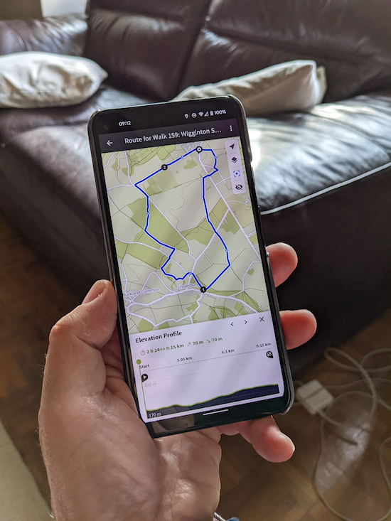 |
| One of our walks downloaded to the free version of Komoot |
 |
| One of our walks downloaded to the free version of GPX Viewer |
When one of our KML files is viewed in Google Earth you are able to see a bird's-eye view of the landscape with any geographic annotations that have been added. We usually just add markers for the start and finish, pubs, parking spaces, etc, but if you create your own KML file, or adapt one of ours, you are able to add all sorts of interesting information such as image overlays, video links, lines, shapes, 3D images, and points., see image below.
 |
| Free KML file being used on the free Google Earth |
GPX downloading issues
The free GPX and KML satellite navigation files published on every walk on Hertfordshire Walker are tested several times to ensure they work properly on any compatible device when connected to the internet or a mobile data network.
The GPX and KML files are 'downloads', which means that when you click the link a file containing the data required for you to follow the route will be downloaded to your device.
You can then open the file in any compatible sat nav app you have installed on your device. This will enable you to follow the walk in much the same way sat nav works in a vehicle.
This means your device needs to have 'downloads' enabled.
If you are able to browse the internet on your smartphone but have problems downloading a GPX file to your device the issue will be with your phone or your network settings, not the file on Hertfordshire Walker. Perhaps you are getting a message saying that you are not connected to the internet - when you know you are.
I have listed the following fixes to try to help anyone experiencing issues when trying to download our GPX files to a compatible mobile device.
1: The first is simply to turn your device off, wait a few minutes, then turn it on again.
2: If that doesn't work make sure downloading over your network is enabled on your device. Some people have their phones set to download only when connected to wifi. If this is the case (and if you are happy to download using your network data allowance) you need to change this setting. How to do this will differ from phone to phone so check online for the steps for your make and model.
3: Check that mobile data is enabled on your device. Usually you need to go to settings, network and internet / SIMs / network / then activate mobile data.
4: If your phone is set to download files when on both wifi and your mobile network try switching between wifi and mobile data then back again to see if this helps.
5: If you are still having problems check the browser cache and history settings on your mobile device. You might need to clear both then restart the device. Before you do be sure you are happy to clear all the saved data on the sites you have visited and the data you have previously downloaded.
6: If that doesn't solve the problem go to your downloads folder on your device and check whether there is anything there you need. If not, clear your downloads folder then restart the device.
7: Check you haven't got 'data saver' active on your device. This will restrict what you can download.
8: Check you haven't got a VPN (virtual private network) active which might interfere with what you can access.
9: Check there isn't a form of ad-blocker active on your phone; this could prevent access to downloadable files.
10: If you are still having problems call or pop into your nearest network store (preferably where you bought the phone or signed up for your network data deal) and ask them to make sure your device is set to be able to download when on the network (and not just set to download when connected via wifi only).
Komoot correct route
An important tip for those who use the free version of Komoot to navigate the GPX files that come free with all our walks.
Always choose the 'Open in route planner' option, see image below.
 |
| Always 'Open in route planner' |
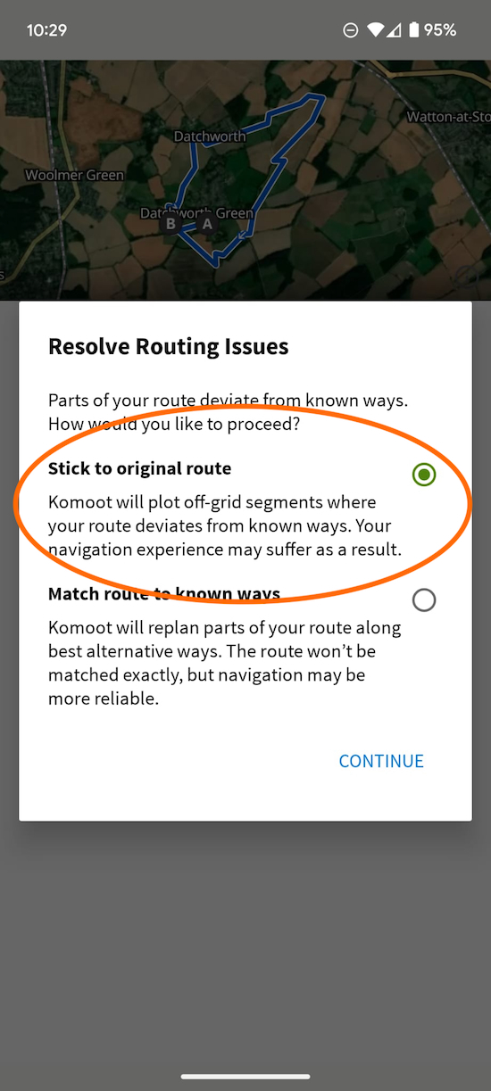 |
| Always choose 'Stick to original route' |
It won't be more reliable, and it could be wrong.
We take a lot of trouble testing all routes before we create a GPX file so you can follow them using sat nav (like in a car). If you use the 'Match route to known ways' option you could be directed along an alternative and incorrect route which won't work with our directions.
So please always use the 'Stick to original route option'.
Why Hertfordshire Walker doesn't have its own app
Some have asked why Hertfordshire Walker doesn't have its own app. The reason is that we don't need one. And it doesn't make sense to build one.
We have a mobile version of the site which includes all you need to download, plan, and enjoy more than 240 free walks in the Hertfordshire countryside.
All you need to do is download one of the many free GPS navigation apps and open our free GPX files in the one you prefer and you are all set.
The reason we don't have our own app is that they need to be continually updated, optimised, adjusted, and maintained in order to meet changing technical requirements and changing user behaviour. That is a costly business and involves calling on the services of developers.
It makes more sense to leave that to the many professional companies who offer access to free navigation apps which are continually being developed.
That way, those walkers who download the free GPX files that we create on Hertfordshire Walker are more likely to enjoy a much better user experience.
Viewing web version on mobile
A regular user of Hertfordshire Walker has asked whether it is possible to see the web version of the site on their mobile device. The answer is yes.
The default view for all mobile devices is different from the version you will see on the web. The content is displayed in one column rather than three for easier viewing, see image below.
 |
| The mobile version of Hertfordshire Walker |
If you scroll down to the bottom of any page you will see a green interactive link under the 'HOME' button that reads 'View web version', see image below.
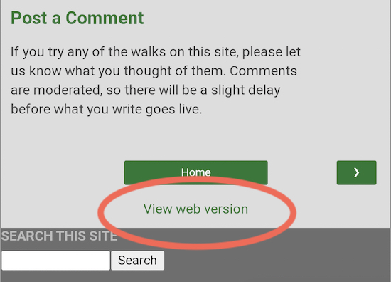 |
| Click on the highlighted link to flip between web or mobile view |
Alternatively, you can flick between the two versions in your smartphone's browser settings.
The two images below show Hertfordshire Walker viewed using the mobile version on the left and the site viewed using the desktop version on the right.
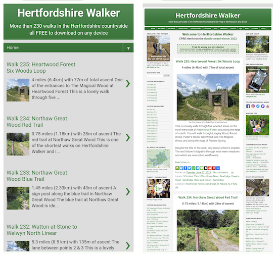 |
| Mobile version of Hertfordshire Walker (left), desktop version (right) |
 |
| The mobile version of a walk (left) and desktop version (right) |
Bookmarking 'favourite' walks
 |
| Click on the black star to bookmark favourite walks |
The answer is 'yes', but, because Hertfordshire Walker is a website available on mobile and desktop, the way to do this is in the operating system that you are using.
So if you are an Android user you need to open your preferred Android browser (I use Google Chrome) then click on the walk on Hertfordshire Walker which you want to bookmark. Once you are on the walk page, select the “Menu” icon (which is three vertical dots). Then select the “Add Bookmark" icon (which is a star - see image above with the star circled in orange). A bookmark is then automatically created and saved to your “Mobile Bookmarks” folder. If you synchronise your mobile activity that bookmark will also show up in your desktop, laptop, or tablet bookmarks.
I am not an iPhone user but apparently this is how it is done on that system. You tap the "Share" button at the bottom of the walk page you want to add to your favourites, and then you tap "Add Bookmark" to create a bookmark in your iPhone's Safari browser. If you save a bookmark to the Favorites folder or choose the "Add to Favourites" option, it'll appear in the Favourites list when you open a new tab in Safari on a computer or iPad.
Smartphone power issues
 |
| We always carry a fully charged power bank on all our walks |
I always carry a fully charged power bank and a power connector. Mine is an Xtorm Fuel Series 18W (see image above). It can charge two phones at once and is an essential piece of kit if you are worried that you might end up with a dead phone when you are out walking. My power bank cost about £25.
I don't often have to use it, but when I am doing a 6-10 mile walk and using GPS, taking photographs, recording What3Word location references, and making notes on my phone, it's good to have that extra power in reserve.
Using GPS offline
 |
| Using GPX offline |
Just download the GPX file for any walk, open in the free Komoot, then when the route loads select 'Store for offline use'.
Komoot will then use GPS to guide you with voice prompts even in areas where there is no data.
If you want to extend your phone's battery life you can switch off your data and rely on the GPS signal. And if you want to reduce battery use even more you can turn off the screen and rely on the voice prompts.
Always make sure you choose 'Stick to original route' when selecting one of our route.
What3Words location references
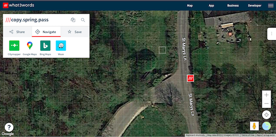 |
| A What3Words location reference on one of our walks |
What3words references are as accurate as GPS coordinates and can help you ensure that you are in the right place.
Here is an example (location - https://w3w.co/copy.spring.pass). That location is taken from Walk 181 in our collection. If you click on the link you will be taken to a map. Click on the satellite view option (bottom right of the screen), and you will be shown a satellite image of exactly where you should be, see image above. Zoom in or out for clarity. Then click the location button (the circle with a dot in the middle) to see where you are. You can then compare your location with where you should be, then check the directions in our walk to get to the right place.
With our free GPS files, maps, directions and W3W we hope you will never get lost.
Getting lost
 |
| Image by Vera Kratochvil released under Public Domain Licence |
So, if you are following one of our routes and come a cross a sign saying 'private' or 'no entry', please stop. You have gone the wrong way.
Check the directions and W3W references and, better still, the GPS navigation files to get back on track.
Hertfordshire Walker can take no responsibility for people who trespass because they have misread the directions.
Footpath names and numbers
All footpaths in Hertfordshire have names and numbers. These include reference to the parish they are in.
We include those details in the directions for our walks so that ramblers can cross-reference with the Hertfordshire County Council rights of way (ROW) map if they choose.
Please be aware that the signs on the paths sometimes contain the numbers, but not always, and they never contain the parish names.
Posts along the way displaying the ROW signs often have the numbers written on them, which is why we include them in the directions.
The Hertfordshire County Council ROW map
 |
| Hertfordshire rights of way signs |
Compass points
 |
| It's worth carrying a compass, or a compass app, on our walks |
The compass references we include are approximate. When I write the directions I look at the map I have created then estimate the direction based on simple compass points. I use cardinal direcitons, such as N (north), S (south), E (east), and W (west) and the four ordinal directions of NW (north-west) NE (north-east), SW (south-west), and SE (south-east). I also add points in between, so NNW (north-north-west) would be halfway between NW and N. I do not go down to the next level which are the 16 'quarter winds' such as NEbE (a line between NE and E).
The illustration above gives a rough idea of how those points work.
What to wear
We recommend you wear water-resistant boots for our walks. Some of the footpaths cross fields of wheat or rape, which can result in you getting wet after rain or in the early morning. Also, many paths go through long grass, which can be heavy with dew if you are starting the walks early.
We always have three pairs of boots on the go. One pair for the longer and more rugged walks we do, lighter boots for summer walks, and wellies for walks where we expect to get muddy and wet - especially in the winter months.
We also recommend you wear long trousers that dry out quickly, or carry a stick to push back any nettles that encroach on the path.
Most of walks at this time of the year involve mud. It's all part and parcel of getting off the beaten track and exploring Hertfordshire's wonderful network of public rights of way.
Keeping hydrated
 |
| Carry enough water when you set off for a walk |
First aid
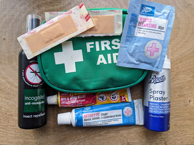 |
| Suggested first aid kit for walkers |
Insects
.jpeg) |
| Watch out for ticks when walking in the countryside |
We always carry insect repellent with us.
 |
| It's worth taking insect repellent with you when walking |
- cover your skin while walking outdoors and tuck your trousers into your socks.
- use insect repellent on your clothes and skin.
- stick to paths whenever possible.
- wear light-coloured clothing so ticks are easier to spot and brush off.
Livestock
Some of the walks go through fields where livestock graze. At certain times of the year, particularly during the spring and summer, animals may be more frisky. Please take care at all times. And if you have dogs, please obey any warning signs or requests to keep your pets on a lead.
Shaded walks
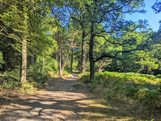 |
| The yellow route on Walk 56, The Great Wood |
It's a great idea. The trouble is that a route walked in the early morning will have a different grading than the same walk undertaken in the afternoon; east-facing paths might be in the sun in the morning but in the shade in the afternoon.
We already have a page listing some shaded walks, but here are two suggestions for those wanting to try other walks that avoid too much sun.
1: If you are planning to do one of our walks, take a quick look at the map that is published with the walk directions and check the amount of woodland or hedgerow shown. Heavily wooded maps, where the paths go through the woodland, should offer some shade. Maps such as the one below show little woodland and will be exposed to the sun.
 |
| Walk 197: Buntingford East Short Loop has little shade |
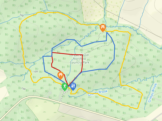 |
| The three routes for Walk 56: The Great Wood, Northaw |
2: Going back to the suggestion of a rough percentage grading for shade, perhaps there could be a crowd-sourced assessment involving all users of Hertfordshire Walker.
If those who complete our walks were to post a comment at the foot of the walk page they would be able to let others know how much shade they experienced. Perhaps something such as: "we started this walk at 9am and estimate that about 45% is in the shade".
By adding a comment you would be helping fellow walkers assess whether the walk offered enough shade for them.
Pubs
Many of Hertfordshire's pubs have been struggling since the pandemic. As a result, some of those mentioned in our walks may have closed. Unfortunately we are unable to keep tabs on all the pubs in order to update the information. Over the past 25 years we have been adding links to pubs featured in the walks, but some of these links might be out-of-date due to pubs closing or changing hands. We recommend you look up the pubs current contact details in order to check opening hours before setting off in order to avoid disappointment.
We have a list of all the pubs mentioned on our walks in the left-hand column of the website and on our ‘Pubs on our walks’ page featured on both the website and the mobile version of the site. If you click on the pubs name you will be taken to a page with a list of all the walks that feature that pub.
Closures
The Hertfordshire County Council ROW (rights of way) department has a team of officers who continually monitor the state of the public ROWs across the county.
From time to time these ROWs need to be temporarily closed. This can be because of a broken footbridge, an unsafe surface, a dispute with a landowner, utility and road works, and building development.
The ROW team keeps a spreadsheet of all closures which it shares with Hertfordshire Walker every month. We then update a page on Hertfordshire Walker titled 'Closures' which is available on both our website and mobile version.
The first image below show where you can find the page on the web version of Hertfordshire Walker.
 |
| The two links to the 'Closures' page on the web version |
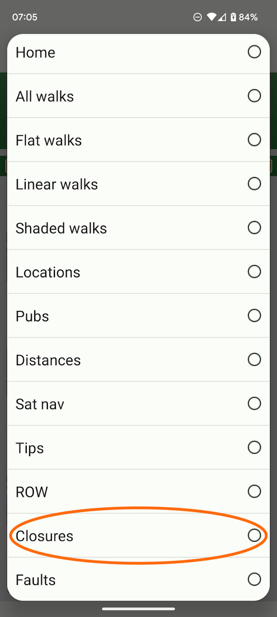 |
| The link to the 'Closures' page on the mobile version |
Reporting faults
 |
| Please report any public rights of way issues directly to Herts CC Image courtesy of Alison Anscombe |
You might find a public right of way has been ploughed over at certain times of the year and the route has not been reinstated. Perhaps crops have been allowed to grow over a footpath or bridleway.
The law states that farmers should "avoid cultivating a cross-field footpath or bridleway", but, if they have to cultivate they must make sure the footpath or bridleway "remains apparent on the ground to at least the minimum width of 1 metre for a footpath or 2 metres for a bridleway, and is not obstructed by crops".
They must also ensure that the public right of way "is restored to at least the minimum width so that it’s reasonably convenient to use within 14 days of first being cultivated for that crop and 24 hours of any subsequent cultivation, unless a longer period has been agreed in advance in writing by the highway authority".
A growing number of fellow walkers who download and follow our walks have taken on to report overgrown or blocked paths, broken signs, rotten footbridges directly to the council. Together we are working to keep our wonderful Hertfordshire footpaths, bridleways, and byways open for the enjoyment of all.
Golf courses
We have added a note to all walks that cross golf courses via public rights of way so that those walkers who want to avoid them can do so. If you are shouted at or abused when crossing a golf course please report the incident to the HCC ROW team and they will look into it. It might also be worth contacting the golf club.
Flooding
 |
| Flooding photograph courtesy of Katherine Ellis |
Treating boots
 |
| It's important to wash and treat boots, especially after walking through mud |
Leave a comment
We love hearing from people who have enjoyed our walks. Please leave a comment in the box beneath every walk. You might have spotted a mistake in my directions, or you might have a suggestion to make about the route, or some other information to share about the local history or environment. All contributions are welcome. Comments are pre-moderated, so there will be a delay in your comments going live.
If you are on Facebook, please also consider joining our friendly and helpful members-only Hertfordshire Walker Facebook Group where people are sharing photographs and comments about the walks they do. It's also the place to find Hertfordshire walking groups open to new members. Everyone is welcome.
Layers on maps
A follower of our walks has just contacted me as follows. "Love your walks thank you BUT my Google maps constantly shows the outline of Hertfordshire and all the walks now. Any idea how to remove them".
If you are also experiencing this problem it's easy to fix. The issue is to do with map 'layers'. At some point the person will have viewed a Google map I created showing all the starting points for all the walks on our site. Doing so has created a 'layer' with all that data superimposed on their Google maps.
If you have the same problem it's easy to turn off - as it is for any 'layer' that might be on your map.
There are two screenshots below. The first, the green one, shows a Google map with our Hertfordshire Walker 'layer' showing all the starting points. To the right near the top is the layers icon, which I have circled in orange with an orange arrow pointing at it. Click that.
 |
| The layer button circled in orange |
 |
| Turn off the layer, circled in orange |
Share on social
 |
| Sharing buttons on the Hertfordshire Walker website |
If you are sharing from the mobile version of Hertfordshire Walker you will need to click the three vertical dots at the top right of the page, scroll down to 'Share' then select the social media platform you want to use.
The eight icons on the website version are from left to right: PrintFriendly (which lets you delete elements from the directions to reduce pages printed), Mastodon, Facebook, Threads, X (formerly Twitter), WhatsApp, SMS, and a plus sign which, when clicked, reveals dozens more options.
About this site
You can find out who is behind this site along with some tips for preparing for the walks by visiting our about page. Information about the content that appears on the site is set out on our copyright page.


