 |
| The Hertfordshire Walker team plotting a new route |
Preparation = four hours
 |
| We have a map showing every starting point |
We try to avoid walking through built-up areas unless it is absolutely necessary for creating a loop or accessing areas we would like to visit.
To plot a route I use the Ordnance Survey (OS) app (and sometimes OS maps) to search for public rights of way that cross open countryside and, if possible, pass a pub.
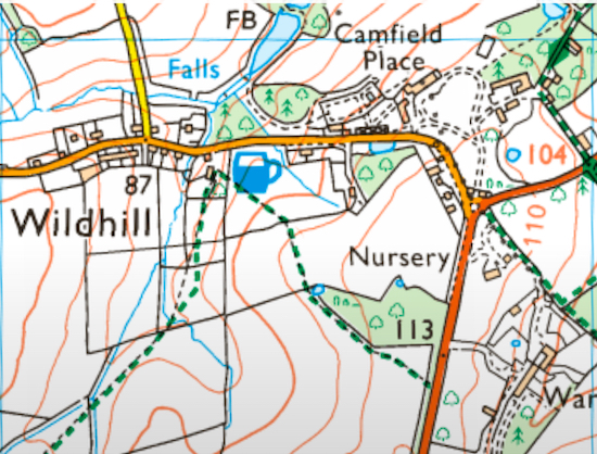
The following screenshot, taken from my OS app, shows countryside near Essendon in Hertfordshire. The green lines are footpaths or bridleways. The blue tankard marker is a pub, The Woodman at Wildhill.
 |
| Screenshot of the OS app |
When the outline for the walk is complete I give it a name and mark it as private (because I need to test it before making it public). Once saved, the app shows the distance and the elevation of the walk. I make a note of these details to add to the walk's directions later in the process.
 |
| Screenshot of the MapHub site |
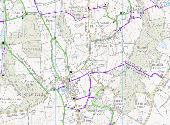
Still on the MapHub site I then zoom in on the new map and carefully plot a new route over the OS route imported earlier making sure that every bend and turn is accurate. It's important at this point to zoom in as much as possible to ensure that no detail is missed. I then save the new route again, delete the imported OS GPS route, and make a note of the new distance (because it will have changed).
The next job is to add more information to the MapHub map. At this point I add markers to show the start/finish point(s), junctions, any points of interest, and any pubs and cafes along the way. We have a page which lists all the pubs and cafes on or close by our routes.
I then visit the Hertfordshire County Council (HCC) Rights of Way (ROW) page and open the 'definitive map'. According to HCC the map is: "A legal record of public rights of way in Hertfordshire". It is also available in a Google Maps version so you can check as you walk.
 |
| Screenshot of a HCC ROW map |
I then return to the new map in MapHub and measure the distance between each point along the way as well as making a note of the approximate compass points for the direction of the route. I estimate the compass direction by looking at the map then adding initials to the walk text, such as N (north), NE (north-east) and SSW (south-south-west). This are to give walkers a rough idea of the direction to head. I also add terms such as left, right, and straight on for those not family with compass references.
Using a text editor - I use the free BBEdit - I start writing the script. BBEdit enables me to include basic computer code written in html. I create a new line for each marker point used earlier on the MapHub map.
I then add information such as direction, distance, ROW names and numbers and leave a space at the end of each line for the location of junctions.
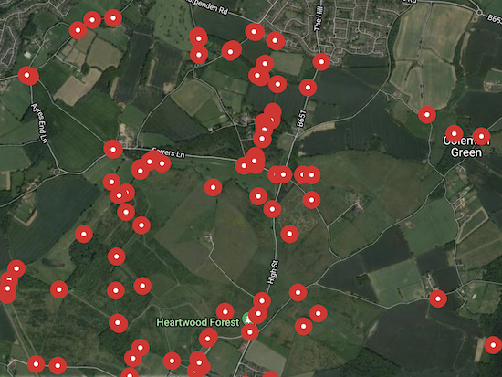
Next I open the What3Words (W3W) location tool and study the new route using their satellite image option. At each important junction in the walk I click on the spot on W3W, save the reference, copy the link, then paste it into the script in the (location - ) box at the end of each section. I also do this when testing the route so that I have two versions to check against before publication.
 |
| Screenshot showing some of the location on W3W |
I then save all the work in the OS app, MapHub, W3W, and in my text editor, then print out copies so that I can check the details against the actual route when testing the walk.
All the above takes about four hours.
Fieldwork = five hours
We then set off for the walk. My wife, Ellie, looks after all the mapping and navigation as we test the route while I make notes and take photographs for every direction point. I always try to take a few extra photos in order to pick one that is an attractive representation of the walk.
We feel it is important to walk every inch of every route to ensure that the GPS directions are correct and that what looks possible on the app and map is actually doable.
As we walk the route we are continually checking the accuracy of the GPS files. Ellie wears a GPS tracking device so that she can record a new version of the route. She sends this to me after the walk so that I can upload it to MapHub to check the route we created before setting off on the walk. I then merge the two, making adjustments where necessary before saving the final version.
 |
| We always check the signs against the numbers on the definitive map |
At all times we are prepared to re-route if necessary. Sometimes we have to retrace our steps and have a rethink. We have often found that we have walked up to nine miles when testing a six mile walk.
We once received a message from a walker who described herself as a “mum with two kids and a dog”. She pointed out that one section of a walk on Hertfordshire Walker went along a road with no pavement and that she had struggled to keep her two children and the dog safe from speeding cars.
We went back, tested the walk, and realised that it was not safe. So we rerouted the walk to avoid the busy road. We now apply the “mum with two kids and a dog” test to all our routes, which means that we try to avoid busy roads or lanes where there isn’t a pavement for pedestrians.
If you select a walk on our site and see the image below this means the walk is being reworked following feedback about problems faced by walkers. These could included blocked rights of way due to a legal dispute, a road or lane becoming busier and more dangerous, or housing developing causing diversions which break the route.
.jpg) |
| Volunteers working on a Hertfordshire public right of way Image courtesy of the Hertfordshire Countryside Management Service |
If the route is starting or finishing at a pub, or passing one along the way, and if that pub is open, we will often pop in to check it out. However, because we start early, many of the pubs are not open when we are passing, so we have not tested all the pubs we have listed on Hertfordshire Walker. The same with cafes mentioned in our directions.
Allowing for all the stopping and starting mentioned above, a six mile route could take up to five hours to complete. The last thing you want to do is rush it and miss important details along the way.
I also like to stop and check birdsong using the free Merlin app and identify wild flowers using the free Flora Incognito on my phone, so that delays us a bit, too.
Processing = four hours
Once home, the new information has to be merged with the earlier work and the webpage for the walk created. I have a large screen on my computer so I can have several applications open at the same time which makes the work easier.
I open the map created before setting off on the walk and upload the new GPS file recorded by Ellie, see where it differs from the one created online or in the app, then adjust where necessary. It is important to make sure there is just one GPS route after this process - the correct one - and that all others have been deleted. This is because anyone downloading the finished product needs to be confident it is accurate.
I then copy the link to the GPS route from MapHub in both GPX and KML and add them to the directions.
The next task is to download the map and format it so that it will work on both the online and mobile versions of Hertfordshire Walker.
It is important to give full attribution for copyright purposes. That is why every map used on our site has the copyright details included.
I resize the map using Google Photos then insert it into the tool I use to build the site. I use Google Blogger, which is free of charge. I adapted a default template to create the three column website look I prefer.
I then have to rework the script with the directions jotted down when testing the route, paying particular attention to difficult junctions where care is needed to describe twists and turns so that people don’t get lost.
The next task is to add the photos which were taken along the way. The images have to be formatted and resized then upload to the webpage. Each has to have a caption and tags.
I then enter new W3W references for every junction or landmark, open the HCC ROW map again, and make a note whether a path is a footpath, bridleway, byway, or permissive path.
I then go through all the computer code that supports both the online and mobile versions to ensure there are no errors and that the walk page renders perfectly. For some reason Google adds some unnecessary code which I have to find and remove.
Proof reading the text is one of the most important parts. Most people find it hard to spot their own mistakes. A second pair of eyes is valuable. Ellie is my second pair of eyes. Once I am happy that everything works as it should I then publish the new walk.
But that's not the end of it. There are six more actions needed to ensure that the website and mobile version are updated properly. There are various pages and boxes on Hertfordshire Walker that need to be changed.
There is a page for ‘All our walks’, one for all the ‘Pubs and cafes on our walks’, our ‘Walks map’ page. I also have to update the locations page and the two Google maps, one for distances and the other for total elevation
There are also several boxes on the Hertfordshire Walker website that need to be updated. One on the left shows the distances and the total elevation of the walks in the collection, another on the left which shows a list of all the walks, and another on the left which shows a list of all the pubs and cafes on the walks.
We sometimes find there is a point where the new route doesn’t work or there is a detail we are not sure about. In such cases we always head out again before publishing the walk to be sure everything works.
Once we are happy with what we have produced we then have to add a description for the new walk, set the start/finish location, and add tags to show the distance and the pubs on the route. The new walk is then published.
I then share it on our Hertfordshire Walker Facebook page and on our Hertfordshire Walker Facebook group. I also share it on our Twitter page, our Mastodon page, our Threads page, and, sometimes, if we have really good pictures, on our Instagram page.
The final processing takes about four hours, added together with the four hours preparation and the five hours field work the total comes to 13 hours.
As you may have noticed I use tools that are free-of-charge. The only cost of running Hertfordshire Walker is the annual registration of the URL, which is £15 a year. All our walks are free-of-charge and always will be. There is no need to register or share any personal or banking details. Just download the walk you want, have a great day out, and let us know how you got on.


Thanks for this. I am interested that you initially plot your routes on the OS maps site as I have taken to mapping them there when I am looking at them for myself. I refer back to your route when I do it and make it public. Have I been duplicating your routes? I don't think they have appeared on my searches there.
ReplyDeleteHi TCB,
DeleteI don't make my OS versions public because, at the point I make the I have not tested them, and I wouldn't want to publish something untested. So that will be why you won't find them in OS.
David
My word l never thought you both put in do much time and effort to create these walks. I am so grateful to you both as l have lived in Hertfordshire my entire life and have discovered areas of it for the first time using your app. I just can not thank you both enough.
ReplyDeleteThank you.
Barry Walker
Hi Barry, really nice of you to say that. Thanks. It means a lot. Our walks will always be free to download and enjoy online and on mobile. We don't have a paid-for subscription app, but instead prefer to share our hobby totally free-of-charge with fellow walkers like you. Thanks again for the feedback. Dave & Ellie
DeleteIs it worth going back and updating them? I understand it is more work for you. I hope you're ok with me labelling the routes I add and linking them to your site?
ReplyDeleteHi TCB,
DeleteI guess I could upload them to the OS app once they have been fully tested. It's just finding the time. :-)
David
Would just like to share my thanks for your wonderful website. I completed two walks this weekend and the instructions and what 3 words points made navigation so easy - very useful for someone new to walking in unfamiliar countryside alone! Your significant amount of work is much appreciated!
ReplyDeleteThank you so much for you comment. I am so glad you are enjoying the walks. My wife and I love sharing them and it's great to read about how much people are enjoying them. David
DeletePhew - exhausted just reading it😅. Seriously, the work you do is amazing and hugely appreciated. I’m 100% (ok 99%!) reading a road map, navigating on roads etc but really struggle off-road as so often RoWs are not clear/not signposted and my distance estimates always way out🤦♀️. Without your wonderful service i would never be brave enough to explore new areas. Thank you so much for everything you and your wife do 🦸♂️🦸♀️😇😇
ReplyDelete:-) Thanks for such a lovely comment. And I am glad the directions help. I think a lot of people are good at map reading but need a little help to make sense of footpaths that are off the beaten track. Ellie (my wife) and I just love exploring and sharing the routes with people who appreciate them. Thanks for the feedback. David (and Ellie).
DeleteThank you so much for all the work you do. I found the website during lockdown and have used it ever since. I do love reading the exploits of others and am also grateful to them for the valuable feedback they provide. I'm not walking much at all due to an injury but hope to be back soon. Thank you once again.
ReplyDeleteHi Sarajane, thanks for your kind words. I am so sorry to hear about your injury. I hope you are up and about again soon.
Delete