8.6 miles (13.8km) with 141m of total ascent
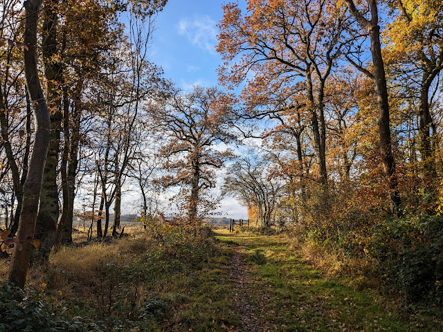 |
| Knebworth footpath 25 approaching point 7 |
This linear walk includes stretches of attractive woodland and wide open countryside with excellent views. As with all our station-to-station walks the route starts and finishes in urban areas. You will cross the A1(M) and the East Coast Mainline twice which means you will be aware of traffic and train noise for much of the route. However, despite that, the walk is a really enjoyable route and there are some lovely stretches that are worth the effort.
When we tested the walk in November 2023 there were several muddy sections but we managed to navigate them wearing walking boots.
There are opportunities for refreshments at
The Lytton Arms (location -
https://w3w.co/trials.exists.beams) in Old Knebworth,
The Robin Hood & Little John (location -
https://w3w.co/wipe.lowest.vest) at Rabley Heath,
The Red Lion (location -
https://w3w.co/curvy.shape.parts) and
The Chequers Inn (location -
https://w3w.co/motion.drama.ties) both at Woolmer Green,
The Cowper Arms (location -
https://w3w.co/stones.ever.margin) close to Welwyn North Station, and
The Deli Stop (location -
https://w3w.co/early.salad.dish) at Welwyn North Station. Please check for opening times to avoid disappointment.
Fly through preview of walk
If you want to check what sort of landscape you will be crossing before you set off on this walk you can view a short 3D video of the route below. It's created using the free version of
Relive.
Directions
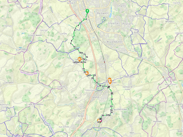 |
Map for Walk 249: Stevenage to Welwyn North Linear
Click on the map above for a larger version
Created on Map Hub by Hertfordshire Walker
Elements © Thunderforest © OpenStreetMap contributors
There is an interactive map below these directions |
Those with GPS devices can download
GPX or
KML files for this walk. We've added
What3Words location references for those who use that system. If you print these walks you might want to use the green
PrintFriendly icon at the bottom of these directions to delete elements such as photographs.
1: Exit
Stevenage Station on the retail park side, which is the west side (location -
https://w3w.co/sudden.agenda.swaps). Once in the car park make your way diagonally to the left heading SSW for 540m to the main road exit on Six Hills Way (location -
https://w3w.co/palm.firms.gallons), see map detail below.
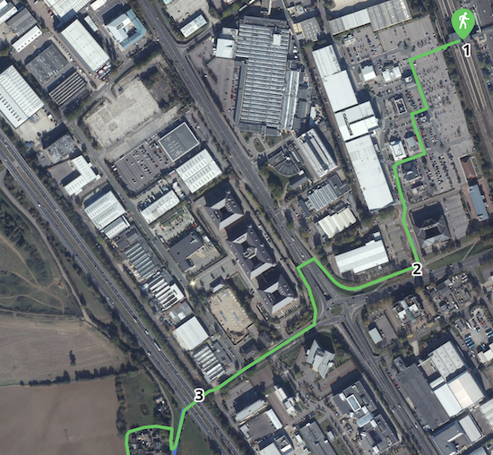 |
| The route between the start of the walk and the A1(M) underpass |
 |
| Turn right on Six Hills Way then head WSW for 140m |
2: Turn right on Six Hills Way then head WSW for 140m until the path bends right (location -
https://w3w.co/flat.icon.glow). Follow the path NNW for 85m until you reach an underpass running beneath Gunnels Wood Road (location -
https://w3w.co/exit.forum.maybe), see image below.
 |
| Turn left then pass through the underpass |
Turn left then pass through the underpass. Once on the other side turn left then head S for 105m at which point the path turns right (location -
https://w3w.co/ritual.tilt.loans). Follow the path WSW for 250m to an underpass beneath the A1(M) (location -
https://w3w.co/posed.feast.noises), see image below.
 |
| Take the underpass beneath the A1(M) |
3: Take the underpass then turn left on the other side following the path uphill for 90m until you reach a lane in the hamlet of Norton Green (location -
https://w3w.co/cattle.prompting.fish), a settlement which dates back to the Romans times.
Turn right at the lane then head N for 50m until you reach a footpath on the left (location -
https://w3w.co/intent.motor.broken), see image below.
 |
| Turn left on Stevenage footpath 64 |
Turn left on Stevenage footpath 64 then head W for 80m before the footpath bends left then heads S (location -
https://w3w.co/lawn.create.mile). You are now on Knebworth footpath 42, which you follow for 95m, with houses on the left and a field on the right, until you reach bend (location -
https://w3w.co/meals.sing.crop).
Knebworth footpath 42 now heads SW for 180m until it cuts through the hedgerow on the left (location -
https://w3w.co/they.waving.aspect), see image below.
 |
| Go through the gap still on Knebworth footpath 42 |
4: Go through the gap then continue heading SW, still on Knebworth footpath 42, for 330m until you reach a junction (location -
https://w3w.co/riots.trio.ships), see image below.
 |
| Cross the junction then continue heading SW |
5: Cross the junction then continue heading SW, still on Knebworth footpath 42, for 165m until you reach a cottage (location -
https://w3w.co/work.buddy.actual), see image below.
 |
| Keeping the cottage on the left head SSW on Knebworth footpath 25 |
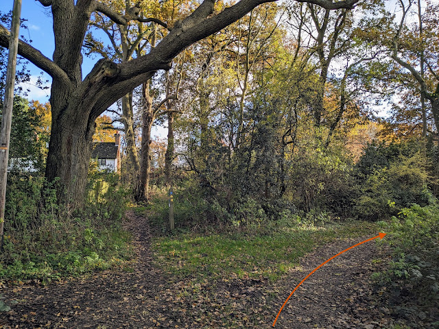
6: Keeping the cottage on the left (see orange arrow on the image above) head SSW now on Knebworth footpath 25.
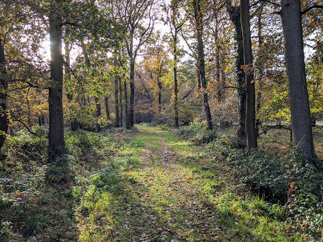 |
| Continue heading SSW through the woodland |
Continue heading SSW through lovely woodland for 615m until you reach a gate and a field (location -
https://w3w.co/brands.fault.friend), see image below.
 |
| Leave the woodland then head SSE with the woodland on the left |
7: Leave the woodland then turn left heading SSE with the woodland on the left and field on the right for 95m to a right-hand bend (location -
https://w3w.co/healthier.ideal.token), then continue as Knebworth footpath 25 heads SSW for 265m to a gate in the hedgerow on the left (location -
https://w3w.co/inform.purely.poet), see image below.
 |
| Go through the gate then head SW still on Knebworth footpath 25 |
8: Go through the gate then head SW for 230m, still on Knebworth footpath 25, until you reach a gate leading to a farmyard (location -
https://w3w.co/rental.yappy.cook), see image below.
 |
| Go through the gate then head SE through Burleigh Farm |
9: Go through the gate then head SE through Burleigh Farm on Knebworth footpath 24. It's worth stopping to read the information board on the first building on the right as you enter the farmyard. Burleigh farm shares some fascinating information about what the crops it is growing and the flora and wildlife you might see as you follow the public rights of way across its land.
 |
The information board at Burleigh Farm
Click on the image for a larger version |
Continue heading SE on Knebworth footpath 24 for 365m until you reach woodland (location -
https://w3w.co/chef.manual.rental), see image below.
 |
| Enter the woodland, still on Knebworth footpath 24 |
10: Enter the woodland, still on Knebworth footpath 24, then continue heading in a south-easterly direction for 195m until you reach a gate leading to the
Knebworth House Estate (location -
https://w3w.co/using.liability.soak). Please read the noticeboard about deer as you enter the gate.
You are permitted to cross the Knebworth House Estate without an entry ticket if you keep to the public rights of way and do not use or visit any of the estate's facilities. If you are approached by a staff member explain to them that you are passing through on public footpaths. But it is important that you do not stray from the route described below.
 |
| Once through the gate keep left still on Knebworth footpath 24 |
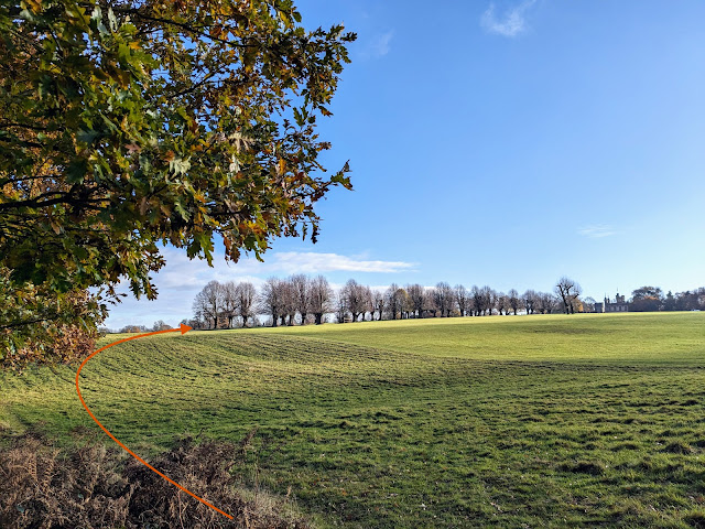
Once through the gate keep left then follow Knebworth footpath 24 SE for 100m until you reach a clearing (location -
https://w3w.co/pure.trap.estate), see image below.
 |
| Turn left at the clearing on Knebworth footpath 22 then head ENE |
11: Turn left at the cleaning on Knebworth footpath 22 then head ENE for 125m until you reach an avenue of trees (location -
https://w3w.co/prep.bulb.bigger), see orange arrow on the image above.
 |
| Photograph of deer at Knebworth courtesy of Sarah Hurst-Cox |
There is a good chance you will come across herds of deer. Keep your eyes peeled as you walk the public rights of way.
 |
| Turn right at the avenue of trees then head SSE |
12: Turn right at the avenue of trees then head SSE for 340m along a metalled track which is also Knebworth footpath 21. Continue until you reach a junction, with Knebworth House straight ahead.
 |
| Cross the junction then turn left |
13: Cross the junction then turn left and walk across the grass heading E on Knebworth footpath 19 for 105m until you reach a gate leading into the
Church of St Mary and St Thomas (location -
https://w3w.co/gets.ends.choice), see image below.
 |
| Follow the path through the churchyard exiting at a covered gate |
The church is a Grade 1 listed building dating back to the 12c. Follow the path to the right and right again exiting the churchyard at a covered gate (location -
https://w3w.co/grand.keys.employ).
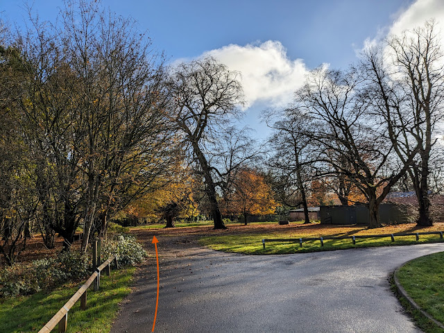
14: After exiting the churchyard head SE for 150m along a metalled track, which is also Knebworth footpath 18, continuing until the metalled track bends right (location -
https://w3w.co/uses.salt.speech), see image below.
 |
| Continue heading SE still on Knebworth footpath 18 |
Leave the metalled track at this point then continue heading SE, still on Knebworth footpath 18, until you reach an exit gate where you leave the Knebworth House Estate (location -
https://w3w.co/soon.skirt.album).
After leaving the estate you will come to a road. Cross the road diagonally to your left to reach a footpath (location -
https://w3w.co/gums.gives.bravo), see image below.
 |
| Follow Knebworth footpath 16 SE and downhill |
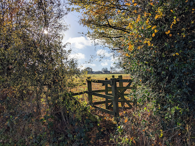
15: Follow Knebworth footpath 16 SE and downhill, with the hedgerow on the right and field on the left, for 140m to a junction (location -
https://w3w.co/noble.surely.small). This stretch and the next can be muddy and slippy in wet weather. Continue heading SE, still on Knebworth footpath 16 but now heading uphill with the hedgerow on the right and field on the left, for 140m until you reach a gate in the hedgerow on the right (location -
https://w3w.co/chose.fats.form), see image below.
 |
| Turn right through the gate, still on Knebworth footpath 16 |
16: Turn right through the gate, still on Knebworth footpath 16, then head SSW for 275m, passing a play area on the left (location -
https://w3w.co/drew.bolt.neat) and continuing until you reach Park Lane (location -
https://w3w.co/mild.music.fans).
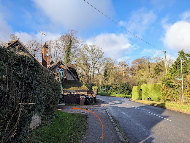
17: Turn right on Park Lane then head WNW for 160m until you reach a footpath on the left (location -
https://w3w.co/deeper.waters.scam), see image below.
 |
| Turn left on Knebworth footpath 13 |
At this point, if you need refreshments, and if The Lytton Arms is open, you could continue along the road and follow it as it bends left for 405m until you reach the pub (location - https://w3w.co/cafe.villa.later). After your visit you can take Knebworth footpath 14 to rejoin the route at a footpath junction (location - https://w3w.co/carbon.vibrate.device), see mini-map below.
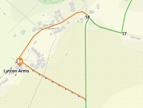 |
| The optional detour to The Lytton Arms |
18: If you don't want to take the detour, turn left on Knebworth footpath 13 then head S between arable fields for 765m until you reach woodland. This section can be muddy after rain, but we were fine walking it in November in boots.
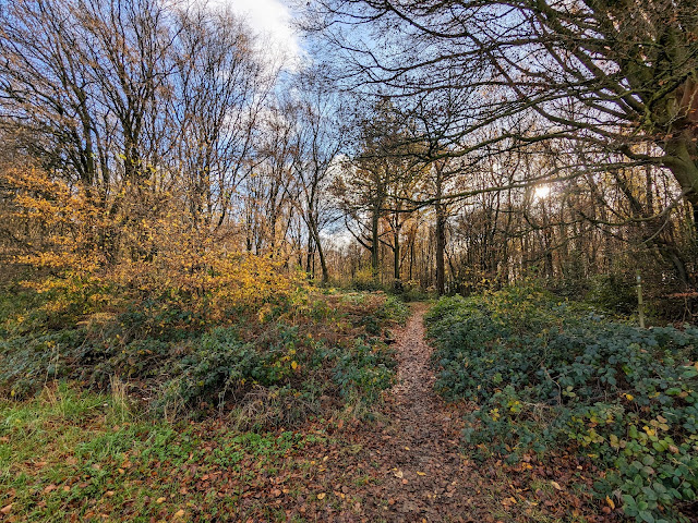 |
| Enter the woodlands, still on Knebworth footpath 13 |
19: Enter the woodlands, still on Knebworth footpath 13, then head SE for 295m until you reach Slip Lane (location -
https://w3w.co/else.comical.sunk). This section can also be extremely muddy and there is evidence that walkers have created parallel paths alongside the muddy sections.
20: When you reach Slip Lane turn left then head SE for 385m until you reach a footpath on the left at a point where the lane bends right (location -
https://w3w.co/taxi.broad.pizza), see image below.
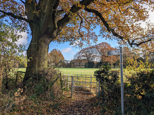 |
| Turn left on Codicote footpath 29 |
At this point, if you need refreshments, and if The Robin Hood & Little John is open (it was "closed until further notice" at the time we mapped this walk) The pub is 50m further along Slip Lane (location - https://w3w.co/being.gifts.slip).
21: Turn left on Codicote footpath 29 then head NE for 155m to a footpath junction (location -
https://w3w.co/lamp.polite.else), see image below.
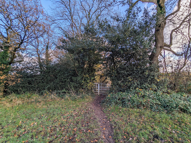 |
| Go through a metal gate then turn right to reach Knebworth footpath 10 |
22: Go through a metal gate then turn right to reach Knebworth footpath 10 which you follow ENE for 535m, with the hedgerow on the left and field on the right, until you reach Spinney Lane (location -
https://w3w.co/excuse.quest.crisp).
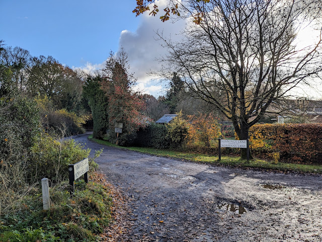
23: Turn right on Spinney Lane then head SW for 285m until you reach a lane on the left (location -
https://w3w.co/aura.drift.edge), see image below.
 |
| Turn left on Ninnings Lane |
24: Turn left on Ninnings Lane then head SE for 70m where Ninnings Lane goes off to the right and you continue heading SE now along Normans Lane, which is also Welwyn BOAT 12 (
byway open to all traffic).
Continue heading SE on Welwyn BOAT 12 for 435m until you reach a tunnel under the A1(M) (location -
https://w3w.co/slate.gates.having), see image below. As you walk this stretch don't worry if you hear
wolf whistles on the right of the path. It's harmless; the route passes an aviary which is home to a couple of parrots who have developed interesting vocabularies.
 |
| Go through the tunnel then follow Welwyn bridleway 12 |
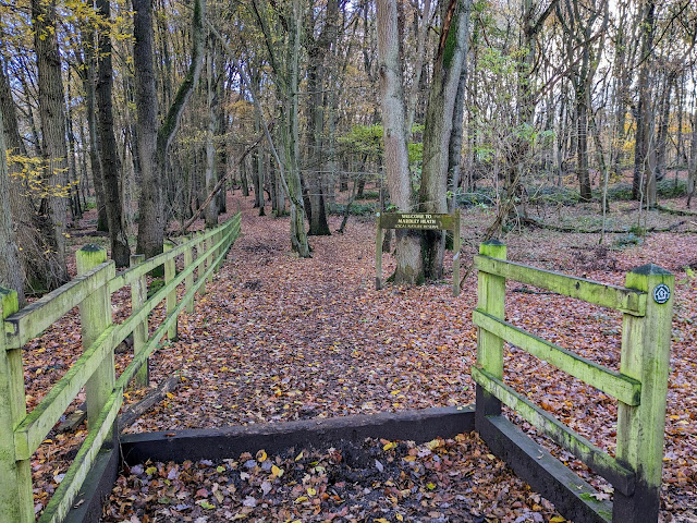
25: Go through the tunnel then follow Welwyn
bridleway 12 as it bends right then enters the
Mardley Heath Nature Reserve (location -
https://w3w.co/lifts.puns.monday), see image below.
 |
| Follow Welwyn bridleway 12 SE through the nature reserve |
Follow Welwyn bridleway 12 SE for 325m until you reach a junction in the tracks (location -
https://w3w.co/event.they.stir), see image below.
 |
| Continue on Welwyn bridleway 12, now heading in an easterly direction |
26: Continue along Welwyn bridleway 12, now heading in an easterly direction, for 275m until you reach the Mardley Heath car park (location -
https://w3w.co/heats.wounds.healers).
27: Exit the car park then turn left on Heath Road which you follow in an easterly direction for 455m until you reach Mardley Hill (location -
https://w3w.co/splash.hiking.water).
There is an unofficial track which runs parallel to the road inside the reserve and then alongside a field if you want to avoid walking on the road.
There is the option of turning left when you reach Mardley Hill to visit either The Chequers Inn (location - https://w3w.co/liability.office.grit) or The Red Lion (location - https://w3w.co/decent.noise.lonely) both a short detour to the north.
28: When you reach Mardley Hill turn right then head SW for 70m until you reach a track on the left (location -
https://w3w.co/desire.doors.faced), see image below.
 |
| Turn left on Woolmer Green bridleway 10 |
29: Turn left on this track, Woolmer Green bridleway 10, then head SE for 545m until you reach Robbery Bottom Lane (location -
https://w3w.co/usage.gained.scars).
30: Turn right then head S along Robbery Bottom Lane until you reach a bridleway on the left at the point where the lane bends right (location -
https://w3w.co/puzzle.chop.rating), see image below.
 |
| Turn left on Woolmer Green bridleway 24 |
31: Turn left on Woolmer Green bridleway 24 then follow it S for 410m to a fork (location -
https://w3w.co/vital.until.marked), see image below.
 |
| Take the right fork Woolmer Green bridleway 26 |
32: Take the right fork then continue heading S, now on Woolmer Green bridleway 26. After 385m you cross a parish boundary (location -
https://w3w.co/timing.lock.pack) and the track you are on becomes Welwyn bridleway 26.
Continue heading S for 210m until you reach a junction (location -
https://w3w.co/towers.feeds.cones), see image below.
 |
| Keep left, still on Welwyn bridleway 26 |
33: Keep left, still on Welwyn bridleway 26, then head S for 315m to a junction (location -
https://w3w.co/deal.speeds.fear), see image below.
 |
| Keep left at the junction, still on Welwyn bridleway 26 |
34: Keep left at the junction, still on Welwyn bridleway 26, then head SE for 90m to a junction (location -
https://w3w.co/chats.cried.plates), see image below.
 |
| Keep right at the junction, still on Welwyn bridleway 26 |
Keep right at the junction, still on Welwyn bridleway 26, then head SW for 150m until you reach Harmer Green Lane (location -
https://w3w.co/battle.mining.live), see image below.
 |
| Cross Harmer Green Lane then follow the track on the other side |
35: Cross Harmer Green Lane, turn right, then follow the track on the other side SW for 290m until the path meets and crosses the road (location -
https://w3w.co/hotel.enhancement.packet), see image below.
 |
| Cross the road then continue heading SW across a green |
36: Cross the road then continue heading SW across a green for 60m until you reach Harmer Green Lane again (location -
https://w3w.co/middle.last.dark).
Turn right on Harmer Green Lane then head WNW for 165m until you reach a track on the right (location -
https://w3w.co/doctor.royal.jeeps) see image below.
 |
| Turn right on the track, which is also Welwyn footpath 38 |
37: Turn right on the track, which is also Welwyn footpath 38, then head W for 90m where the footpath leaves the track to the left of a private drive (location -
https://w3w.co/varieties.scout.letter), see image below.
 |
| Continue on Welwyn footpath 38 |
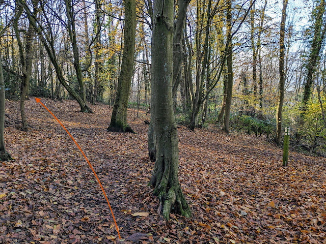
Continue heading W on Welwyn footpath 38 for 275m until you come to a junction (location -
https://w3w.co/lives.lock.island), see image below.
 |
| Keep left at the junction |
38: Keep left at the junction then immediately take the right fork, see image below.
 |
| Follow the right fork, Welwyn footpath 53 |
Follow the right fork, Welwyn footpath 53, then head SW for 325m to a junction (location -
https://w3w.co/star.crowd.pools), see image below.
 |
| Turn left at the junction, still on Welwyn footpath 53 |
39: Turn left at the junction, still on Welwyn footpath 53, then head ESE for 80m to a junction (location -
https://w3w.co/rank.kite.decreased), see image below.
 |
| Turn right at the junction on Welwyn footpath 54 |
Turn right at the junction on Welwyn footpath 54 then follow it S then SW for 90m to Warren Way (location -
https://w3w.co/safe.royal.chip).
Turn left on Warren Way then head S then SW then S again for 230m until you reach a track on the left (location -
https://w3w.co/fingernails.planet.shall), see image below.
 |
| Turn left on the track and follow it SE to Welwyn North Station |
Turn left on the track and follow it SE for 135m to Welwyn North Station car park (location -
https://w3w.co/moral.equal.dining).
If you need refreshments The Cowper Arms (location -
https://w3w.co/bend.kinks.museum) and The Deli Stop (location -
https://w3w.co/manliness.spray.atomic) are nearby.
Interactive map


You will be aware of traffic noise from the A1(M) and the East Coast Mainline for much of this route - although we thought it was worth it because the route is really lovely.
ReplyDeleteMardley heath is not a Woodland Trust site. It is owned by Welwyn Hatfield Borough Council and managed by the council together with the Friends of Mardley Heath. I know as I'm one of the friends.
ReplyDeleteThank you, I have corrected the directions. I was confused because it has a page on The Woodland Trust site. Thanks for pointing it out.
DeleteThanks for this. An excellent walk, one of my favourites from the list. Was definitely on the wet and muddy side in February, I had to find an alternative route at point 20 (with some local help) due to a flood on Slip Lane. Fantastic for wildlife, I look forward to walking it again in the warmer months!
ReplyDeleteGreat, glad you enjoyed it despite the mud and flooding. Another user of our site mentioned the flooding on Slip Lane and I suggested a detour. If you are not already a member please consider joining our friendly Hertfordshire Walker Facebook group where fellow walkers are sharing tips and photos from their walks in the Herts countryside.
Deletehttps://www.facebook.com/groups/hertfordshirewalker
David
I’ve just returned from the walk (mid-March 2025.) A great country walk with some great views. Yes, the noise of the A1 is a little annoying but we live in the Southeast of England not the Yorkshire dales, so I guess we’ve got to put up with it. Thank-you for the excellent guidance, photos and pub suggestions. Had a Guinness at the Robin Hood and Little John halfway along the route. What a lovely pub.
ReplyDelete