5.2 miles (8.4km) with 93m of total ascent
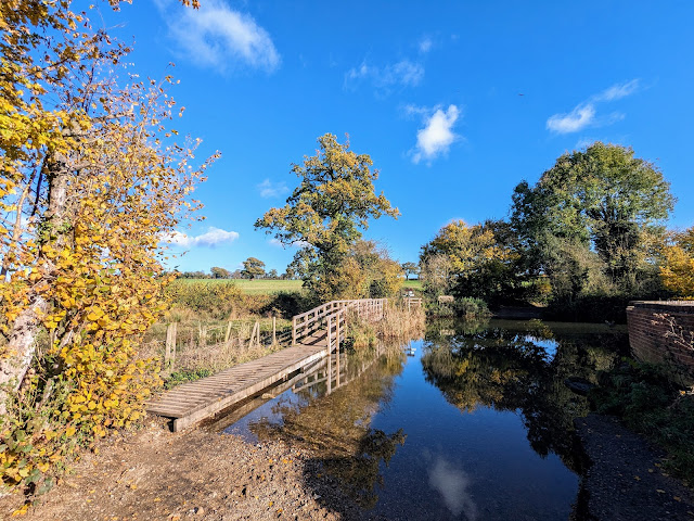 |
| The footbridge at point 10 |
This walk starts and finishes on
Redbourn Common then heads SW to join the
Nickey Line before climbing to merge with part of the Ver Valley Trail. You will pass
Redbournbury Watermill and Bakery and, if you time your visit for Saturday morning between 9am and 1pm you might be able to pick up some freshly baked bread or cakes. The route then crosses the
River Ver before climbing again to
Hammonds End Farm with its fascinating information boards about organic farming.
You will cross three busy roads along the way, the B487 twice at points 4 and 19, and the A5183 once at point 8. We had no problem crossing, but if you have nervous dogs, or are walking with a large group or small children you might want to choose another route.
There is currently free parking (at the time of writing in November 2023) in a car park (location -
https://w3w.co/robot.deeply.grew) on Redbourn Common just off Lybury Lane and close to Redbourn Cricket Club.
There are opportunities for refreshments at
The Cricketers at the start and finish point,
The Holly Bush (location -
https://w3w.co/risen.cute.yours) soon after point 2,
The Chequers Inn (location -
https://w3w.co/lamps.spots.played), a 630m detour from point 8. At point 20 there is the option of a short detour along High Street, Redbourn where you will find
The George (location -
https://w3w.co/shovels.will.keep), and a couple of cafes including
The Queen of Herts (location -
https://w3w.co/name.flag.insect),
The Hub (location -
https://w3w.co/nasal.shop.cowboy), and Coach House Coffee (location -
https://w3w.co/strut.king.else).
Fly through preview of walk
If you want to check what sort of landscape you will be crossing before you set off on this walk you can view a short 3D video of the route below. It's created using the free version of
Relive.
Directions
 |
Map for Walk 248: Redbourn South-East Loop
Click on the map above for a larger version
Created on Map Hub by Hertfordshire Walker
Elements © Thunderforest © OpenStreetMap contributors
There is an interactive map below these directions |
Those with GPS devices can download
GPX or
KML files for this walk. We've added
What3Words location references for those who use that system. If you print these walks you might want to use the green
PrintFriendly icon at the bottom of these directions to delete elements such as photographs.
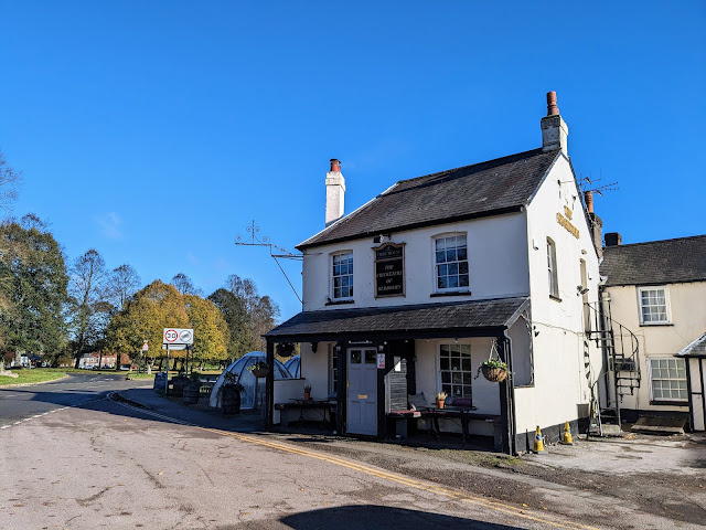 |
| The Cricketers on Redbourn Common |
1: With your back to The Cricketers (location -
https://w3w.co/valve.serves.chest), cross the road then head W across the grass for 35m until you reach a tree-lined metalled path. This is Redbourn footpath 17 which, along this stretch, is also The Chiltern Way (location -
https://w3w.co/served.adopt.pure), see image below.
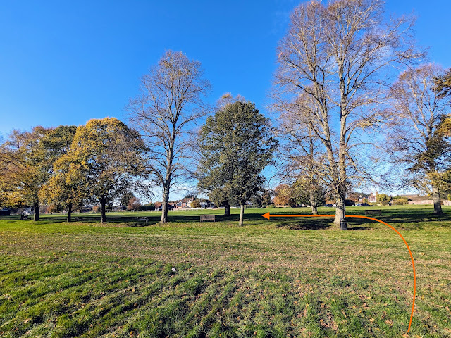 |
| Turn left on the metalled path between the trees |
Turn left on the metalled path between the trees then head SW across the common for 335m, with the cricket club on your right. Continue until you cross Flamsteadbury Lane (location -
https://w3w.co/ducks.reform.advice). Cross the lane then continue heading SW, still on Redbourn footpath 17, The Chiltern Way, for 80m until you reach a road called Church End (location -
https://w3w.co/tune.trace.pure).
2: Turn right on Church End then pass The Holly Bush on your right (location -
https://w3w.co/moods.souk.healers), see image below.
 |
| Continue past The Holly Bush for 40m until you reach a churchyard |
Continue heading WSW for another 40m until you reach a gate leading into the St Mary's churchyard (location -
https://w3w.co/large.could.gather), see image below.
 |
| Go through the gate then head straight on Redbourn footpath 39 |
Go through the gate then head straight on Redbourn footpath 39, with the church on your right (location -
https://w3w.co/inch.sake.hands), see image below.
 |
| You will pass St Mary's Church on the right |
Follow the path as it bends to the left to exit the churchyard at the gate on Hemel Hempstead Road (location -
https://w3w.co/sentences.beside.camp). Turn right on Hemel Hempstead Road then head WSW for 45m until you reach a footpath on the left between the houses (location -
https://w3w.co/fails.label.many), see image below.
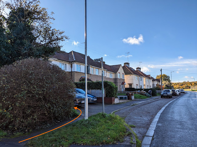 |
| Turn left on Redbourn footpath 34 |
3: Turn left on Redbourn footpath 34 then follow it SSE for 65m until you meet the Nickey Line (location -
https://w3w.co/truck.diner.price). This is the route of the former railway line between Hemel Hempstead, Redbourn and Harpenden.
 |
| Turn left on the Nickey Line |
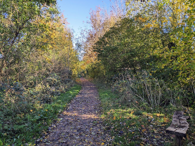
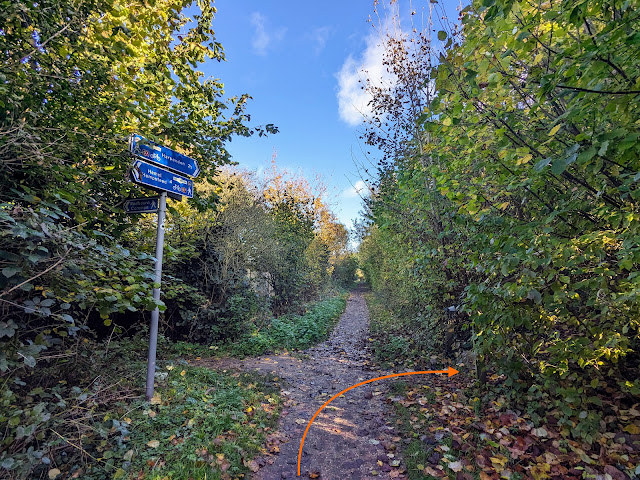
Turn left on the Nickey Line then follow it ENE for 440m until you reach a footpath on the right (location -
https://w3w.co/trader.money.rides), see image below.
 |
| Turn right on Redbourn footpath 38 |
4: Turn right on Redbourn footpath 38 then follow it up and down stairs as it crosses the B487 (location -
https://w3w.co/abode.curvy.spoon). This is a busy stretch of road and care needs to be taken when crossing. Once across, climb another set of stairs to reach a gate (location -
https://w3w.co/small.these.tribe), see image below.
 |
| Go through the gate then head SSE across an arable field |
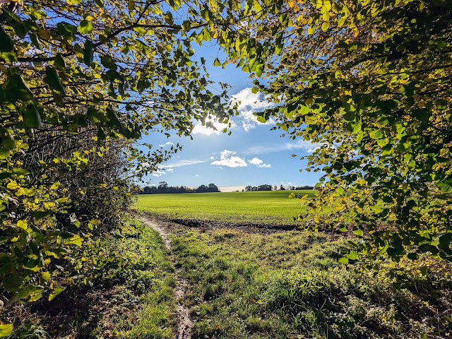
Go through the gate then head SSE across an arable field for 265m, keeping to the right of the telegraph pole, until you reach a gap in the hedge (location -
https://w3w.co/class.danger.stream), see image below.
 |
| Go through the gap then continue with the hedgerow on the left |
5: Go through the gap then continue heading SSE and SE, still on Redbourn footpath 38, with the hedgerow on the left and field on the right. Continue until you reach the corner of the field and a gap in the hedgerow (location -
https://w3w.co/maple.twins.poetic).
 |
| Go through the gap then continue on Redbourn footpath 38 |
Go through the gap then continue on Redbourn footpath 38 now heading SSE and uphill across an arable field for 350m until you reach Beaumont Hall Lane (location -
https://w3w.co/rabble.loved.agents).
 |
| Turn left on Beaumont Hall Lane |
6: Turn left on Beaumont Hall Lane then head ENE for 480m until you pass a farm on the right then reach a footpath on the left (location -
https://w3w.co/socket.most.pram), see image below.
 |
| Turn left on Redbourn footpath 25 |
7: Turn left on Redbourn footpath 25 then follow it NNE across an arable field for 205m until you pass through the hedgerow and reach a yard (location -
https://w3w.co/coffee.waters.craft), see image below.
 |
| Keep right at the yard then head ENE to St Albans Road |
Keep right at the yard then head ENE for 50m until you reach St Albans Road (location -
https://w3w.co/total.bottle.laser), see image below.
 |
| Cross St Albans Road then take Redbourn footpath 29 |
8: Cross St Albans Road. This is a busy stretch and extra care is needed. Once across take Redbourn footpath 29. This is a lovely stretch of footpath as you head ESE for 300m with the hedgerow on the left and field on the right to a bend (location -
https://w3w.co/files.dusty.radio) where Redbourn footpath 29 continues, now heading SSE for 460m, with the hedgerow and River Ver on the left and field on the right until you reach Redbournbury Watermill and Bakery (location -
https://w3w.co/duty.sample.folds), see images below.
 |
| Redbournbury Watermill |
 |
| Redbournbury Bakery |
There are picnic tables outside the watermill where you can eat any buns or cakes you have bought from the bakery and wash them down with cold drinks bought at the watermill.
9: After leaving Redbournbury Watermill and Bakery turn left then head ENE for 50m to a ford with an elevated footpath to the left (location -
https://w3w.co/share.flows.hardly), see image below.
 |
| Follow Redbourn footpath 30 with the farm buildings on the right |
Follow Redbourn footpath 30 in a northeasterly direction for 185m, with the farm buildings on the right, until you reach a pond on the right and a footbridge straight ahead (location -
https://w3w.co/long.buns.comb), see image below.
 |
| Continue across the footbridge to a junction |
Continue across the footbridge heading E for 20m until you reach a junction (location -
https://w3w.co/rice.name.issued).
10: Turn left at the junction on Redbourn footpath 27 then head NNW for 390m until you reach a junction (location -
https://w3w.co/origin.escape.dreams), see image below.
 |
| Turn right on Redbourn footpath 28 |
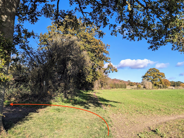
11: Turn right on Redbourn footpath 28 then head NE, with the hedgerow on the left and field on the right, for 310m until you reach a junction (location -
https://w3w.co/tilt.damp.alone), see image below.
 |
| Turn left then head NW with hedgerow on the right and field on the left |
12: Turn left then on a footpath that straddles the parish boundary and is both Harpenden Rural footpath 5 and Redbourn footpath 26. Follow this footpath NW for 160m with hedgerow on the right and field on the left until you come to a footpath on the right (location -
https://w3w.co/frock.secret.boot), see image below.
 |
| Turn right on Harpenden Rural footpath 6 |
13: Turn right on Harpenden Rural footpath 6 then head NE for 355m, with the hedgerow on the right and field on the left, until you reach a junction (location -
https://w3w.co/later.shape.habit), see image below.
 |
| Continue heading NE still on Harpenden Rural footpath 6 |
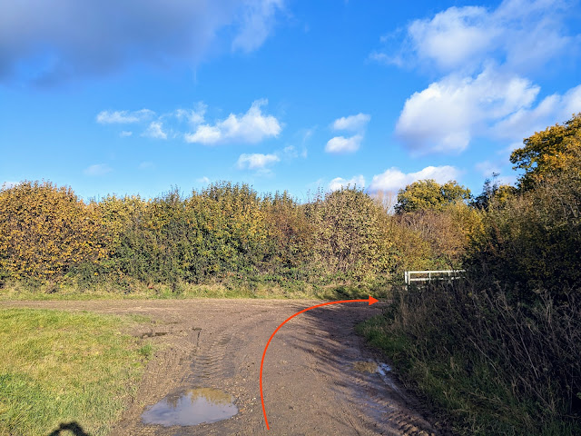
14: Continue heading NE at the junction, still on Harpenden Rural footpath 6, for 260m until you reach a junction (location -
https://w3w.co/kicked.lance.rang), see image below.
 |
| Turn right at the junction, still on Harpenden Rural footpath 6 |
15: Turn right at the junction, still on Harpenden Rural footpath 6, then head ESE for 60m until the footpath bends left (location -
https://w3w.co/oath.seated.sentences). Follow the footpath around to the left then head NE and NNW for 345m passing through Hammonds End Farm and a noticeboard on the left explaining how the farm is run. It's worth reading. The farm leaves four hectares, about the size of 10 football pitches, to provide food for wildlife during the winter months. You will keep passing posts with lilac
QR codes (a type of barcode that can be read easily by a digital device) which those with scanners on their phones can use to find out more about the farm.
 |
| An information board at Hammonds End Farm |
Continue past the farm until you reach a footpath on the left (location -
https://w3w.co/behave.slave.vibes), see image below.
 |
| Turn left on Harpenden Rural footpath 4 |
16: Turn left on Harpenden Rural footpath 4 then head NW along the edge of Harpenden golf course for 100m until you reach a junction and a left-hand bend (location -
https://w3w.co/aims.vague.sounds), see image below.
 |
| Turn left at the junction |
17: Turn left at the junction. You will now follow a mix of
permissive paths and Harpenden Rural footpath 4 to skirt the golf course and avoid walking over a fairway. With the boundary fence on your left head SE for 250m then SW for 415m until you reach a junction (location -
https://w3w.co/dishes.rival.lively), see image below.
 |
| Head diagonally to the left heading WSW to the right of a line of trees |
18: Head diagonally to the left heading WSW still on Harpenden Rural footpath 4. You need to be walking to the right of a line of trees, see image below.
 |
| Head WSW on Harpenden Rural footpath 4 with the hedgerow on the left |
Continue heading WSW on Harpenden Rural footpath 4 with the hedgerow on the left for 185m until you reach a gap in the hedge and a footpath junction (location -
https://w3w.co/economies.chefs.lists), see image below.
 |
| Go through the gap then cross an arable field heading downhill |
Go through the gap then cross an arable field heading WSW downhill for 340m now on Redbourn footpath 20 keeping the telegraph poles on your right, see image below.
 |
| Cross the field then go through a gate |
Cross the field then go through a gate (location -
https://w3w.co/fish.flat.toast) leading to the A 5184 (location -
https://w3w.co/void.plant.song). This is a busy road, so cross with care.
19: Once across the A 518 continue on Redbourn footpath 20 to reach the Nickey Line again (location -
https://w3w.co/themes.corner.admire), see image below.
 |
| Cross the Nickey Line then climb a set of wooden steps |
Cross the Nickey Line then climb a set of wooden steps, still on Redbourn footpath 20, see image below.
 |
| Continue on Redbourn footpath 20 footpath as it weaves its way westerly |
Continue on Redbourn footpath 20 footpath as it weaves its way westerly and becomes a track and then a lane before reaching High Street, Redbourn (location -
https://w3w.co/woven.fork.risk).
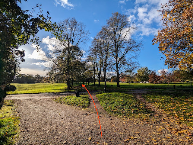
20: Cross High Street then take the footpath between the buildings, Redbourn footpath 17, following it WSW for 190m until you reach Redbourn Common (location -
https://w3w.co/drip.book.down), see image below.
 |
| Head WSW along the tree-lined Redbourn footpath 17 |
Head WSW along the tree-lined Redbourn footpath 17 following it as it crosses the common for 300m back to the starting point.
Interactive map


If you want to buy freshly baked bread from the Redbournbury Watermill and Bakery you will need to do this walk on a Saturday morning. The bakery stall is open from 9am to 1pm. However, a notice on their site says they will not be open on Saturday 16th of December 2023.
ReplyDeleteEnjoyable amble on a chilly winter day. Stopped at the mill for our picnic and picked up some flour and honey. They also had some cakes and bread for sale (Sunday lunchtime) plus you could have a tour of the mill. First time using the download route on the OS map app and it was very easy to follow so we could focus on the scenery and bird life.
ReplyDeleteSo glad you enjoyed the walk and that you and picked a day when the bakery stall was open. We love that place. And glad the GPX file worked well in you OS app. If you haven't already done so, please consider joining our friendly Facebook group where fellow walkers are sharing photos and reports about the walks they have done. David
Deletehttps://www.facebook.com/groups/hertfordshirewalker
Enjoyed this walk on a bright but cold January day. We were prepared for mud across the fields so we wore our wellies - it would have been difficult without them. Luckily we got to the bakery at the Mill a few minutes before it closed and bought a delicious plaited loaf three quarters of which disappeared on the rest of the walk. We were too late to explore the Mill itself so will probably go back another day. Enjoyed the open views and varied scenery and listening to the birds. Lovely cows and calves at the farm who looked so healthy and contented. Crossing the roads was a bit tricky but as long as you waited patiently for a gap it was ok. Easy to park and we had tea at the Queen of Hearts near the end of the walk in Redbourne. Good clear walking directions. Thanks again for all the planning that goes into the walks.
ReplyDeleteGlad you enjoyed it Deborah. And yes, that road crossing is tricky. In fact I wondered whether to publish the walk or not or at least find a way to avoid the crossing, but it was needed to create the loop. If you haven't already done so please consider joining our friendly Facebook group where fellow walkers are sharing their walking experiences and photographs. David
Deletehttps://www.facebook.com/groups/hertfordshirewalker
Did this lovely walk today in glorious spring sunshine today ( 24 March '24). Really enjoyed the variation in this walk - open fields, river sides & bridges, tree covered walkways, farm yards, water mill, overlooked fishing lakes & some 'up & down. Instructions were the best we've followed. Pleased to report that all the arable fields we crossed were dry & mud free. Some of the covered areas & farm tracks still had some muddy puddles but these were easily navagable. Great not to have to clean muddy boots on returning home. Christine Johnson
ReplyDeleteHi Christine, what a lovely report. And I love the photo of the bench you shared on our Facebook group. Thanks for the feedback. David
Delete