6 miles (9.7 km) with 64m of total ascent
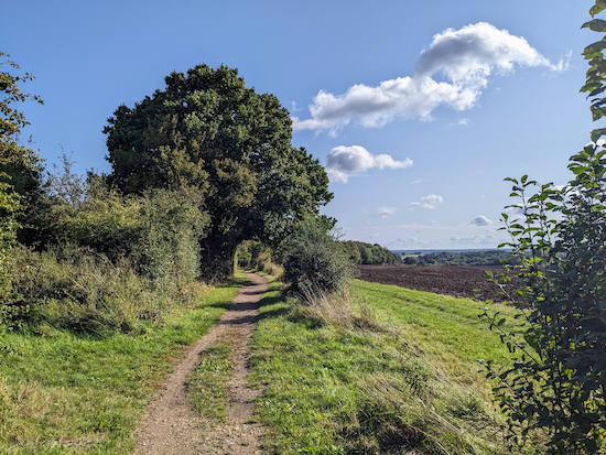 |
| Sandridge bridleway 9 between points 14 & 15 in the walk |
This is a great walk if you like wide open views and stretches of woodland. It starts on Nomansland Common then heads west before looping south then returning through Langley Wood in Heartwood Forest. It includes sections of The Ver Valley Walk and The Hertfordshire Way.
Getting there
There are bus stops outside The Wicked Lady (location -
https://w3w.co/appear.flag.activism) which is 520m NE of the start of the walk. They are served by the number 304, 357, and 612 buses. You can check bus times at
Intalink.
There are two opportunities for parking which were both free-of-charge when we wrote these directions (4/10/2023). The first is the Nomansland car park at the start and finish of the walk (location -
https://w3w.co/beam.goat.bleak). The second is the Heartwood Forest car park at point 18 in the walk (location -
https://w3w.co/worry.fence.demand).
There are two pubs close to the Nomansland car park,
The Elephant & Castle at Amwell (location -
https://w3w.co/decks.notes.recall), and
The Wicked Lady at Nomansland (location -
https://w3w.co/rail.drips.rooms). There is also a cafe,
West End Barns at point 3 in the walk (location -
https://w3w.co/cute.robe.news).
There is the option to take a short detour at point 17 to visit Sandridge where you will find
The Green Man (location -
https://w3w.co/truly.stuff.handed),
The Rose and Crown (location -
https://w3w.co/goes.income.thick), and
The Queens Head (location -
https://w3w.co/result.winks.relay). There is also
Heartwood Tearooms attached to the village store.
Fly through preview of walk
If you want to check what sort of landscape you will be crossing before you set off on this walk you can view a short 3D video of the route below. It's created using the free version of
Relive. Please be aware that the satellite image used by Relieve was taken some years ago and doesn't show the full extent of the forest growth at Heartwood.
Directions
 |
Map for Walk 245: Nomansland South Loop
Click on the map above for a larger version
Created on Map Hub by Hertfordshire Walker
Elements © Thunderforest © OpenStreetMap contributors
There is an interactive map below these directions |
Those with GPS devices can download
GPX or
KML files for this walk. We've added
What3Words location references for those who use that system. If you print these walks you might want to use the green
PrintFriendly icon at the bottom of these directions to delete elements such as photographs.
 |
| Head W from the car park with Ferrers Lane on the right |
1: From the Nomansland car park (location -
https://w3w.co/dust.moss.banks) head W, with Ferrers Lane on the right, for 670m until the path bends to the left (location -
https://w3w.co/snow.ending.towns), see image below.
 |
| Keep left, with the woodland on your right, then head SW |
2: Keep left, with the woodland on your right, then head SW for 80m until you reach a junction (location -
https://w3w.co/angle.kicked.twice), see image below.
 |
| Turn right then head W through the woodland |
Turn right then head W through the woodland for 310m until you reach a metal gate (location -
https://w3w.co/pasta.region.spice), see image below.
 |
| Walk to the left of the gate then continue heading W |
3: Walk to the left of the gate then continue heading W for 120m. You will cross a wooden elevated walkway, see image below, before reaching Ferrers Lane (location -
https://w3w.co/above.steps.merit).
 |
| The wooden elevated walkway prior to reaching Ferrers Lane |
4: Turn left on Ferrers Lane then head WSW for 10m before reaching a
footpath in the hedgerow on the right (location -
https://w3w.co/text.live.level), see image below.
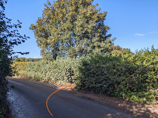 |
| Turn right on Wheathampstead footpath 14 |
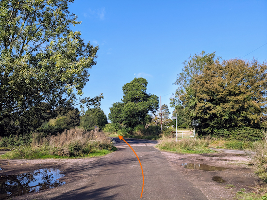
Turn right on Wheathampstead footpath 14 then follow it NW for 945m until you reach Pipers Lane (location -
https://w3w.co/spots.flames.votes), see image below.
 |
| Cross Pipers Lane then head WSW along the pedestrian pavement |
5: Cross Pipers Lane then turn left and head WSW along the pedestrian pavement for 220m until you reach a traffic roundabout (location -
https://w3w.co/waddle.avoid.point),
 |
| Turn left at the traffic roundabout then head SW |
6: Turn left at the traffic roundabout then head SW along Welbeck Rise for 55m until you reach Cross Lane on the left (location -
https://w3w.co/caring.mixer.taped), see image below.
 |
| Turn left on Cross Lane then head SW |
Turn left on Cross Lane then head SW for 750m until you reach a bridge over the
Midland Main Line (location -
https://w3w.co/under.bronze.later). Immediately after crossing the bridge take a
permissive path on the left (location -
https://w3w.co/trio.club.cheeks), see image below.
 |
| Head SSE on the permissive path |
7: Head SSE on the permissive path, with the railway and hedgerow on the left, for 240m until you reach a byway called Mud Lane (location -
https://w3w.co/dots.economies.gentle), see image below.
 |
| Turn right on Mud Lane |
8: Turn right on Mud Lane, which is also Harpenden BOAT 1 (
byway open to all traffic), then head SW for 490m until you reach a junction and a road called East Common (location -
https://w3w.co/speaks.saying.rope), see image below.
 |
| Turn left at the junction then head SSE along East Common |
9: Turn left at the junction then head SSE along East Common for 400m until you reach Ayres End Lane (location -
https://w3w.co/events.crass.voice).
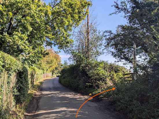
Turn left on Ayres End Lane then head ENE for 80m until you reach a footpath on the right (location -
https://w3w.co/socket.bricks.bets), see image below.
 |
| Turn right on Wheathampstead footpath 47 |
10: Turn right on Wheathampstead footpath 47 then head S, with the hedgerow on the right, for 250m until the path bends to the left (location -
https://w3w.co/damage.cases.bared), see image below.
 |
| Continue on Wheathampstead footpath 47 with the hedgerow on the right |
Follow Wheathampstead footpath 47 as it heads E for 55m then heads SSE for 250m until it reaches a gap in the hedgerow in the corner of the field (location -
https://w3w.co/atoms.silks.arch), see image below.
 |
| Go through the gap then turn right and head SW |
11: Go through the gap then turn right and head SW, with the hedgerow on the right and still on Wheathampstead footpath 47, for 50m until you reach a left-hand bend (location -
https://w3w.co/circle.quit.grades), see image below.
 |
| Turn left at the bend then head SSW with the hedgerow on the left |
Turn left at the bend then head SSW, now on St Michael's Rural footpath 15 and with the hedgerow on the left, for 130m until you reach woodland (location -
https://w3w.co/pits.rocket.global).
Continue, now heading SSE and still on St Michael's Rural footpath 15, for 430m until you reach a junction (location -
https://w3w.co/hints.adjust.stick), see image below.
 |
| Turn left on Sandridge bridleway 9 |
12: Turn left on Sandridge bridleway 9 then head E for 360m until you reach a farmyard (location -
https://w3w.co/coins.trip.stones), see image below.
 |
| Follow Sandridge bridleway 9 through the farmyard |
13: Follow Sandridge bridleway 9 through the farmyard by turning left in front of the barn (see orange arrow on the image above), then continuing between farm buildings before going through a gate (location -
https://w3w.co/stroke.cracks.play), then cross a field before reaching a bridge over the Midland Main Line (location -
https://w3w.co/elite.happy.brief), see map of the route through the farmyard below.
 |
| Public right of way through farmyard in green |
14: Cross the bridge then head E, ESE, then NE, still on Sandridge bridleway 9, for 800m until you reach a footpath on the left (location -
https://w3w.co/fantastic.invest.legs), see image below.
 |
| Turn left, go through a gate, then follow a footpath NNW |
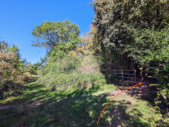
15: Turn left, go through a gate, then follow a footpath NNW for 80m until you reach the entrance to Langley Wood on the right (location -
https://w3w.co/reach.blank.modes), see image below.
 |
| Turn right then enter Langley Wood |
 |
A sign at the entrance to Langley Wood
Click on the image for a larger version |
Turn right, enter Langley Wood, then follow the official path NE for 180m until you leave the wood and reach a bridleway (location -
https://w3w.co/crowd.club.hoping), see image below.
 |
| Turn right on Sandridge bridleway 8 |
16: Turn right on Sandridge bridleway 8 then head ESE for 280m until you reach a footpath on the left (location -
https://w3w.co/cliff.rips.tides), see image below.
 |
| Turn left, go through the gate, then turn right and head E |
17: Turn left, go through the gate, then turn right and head E and downhill for 180m until you reach a footpath crossing just before the main Heartwood Forest car park (location -
https://w3w.co/legal.moves.caring), see image below.
 |
| Turn left then walk just to the right of the information circle |
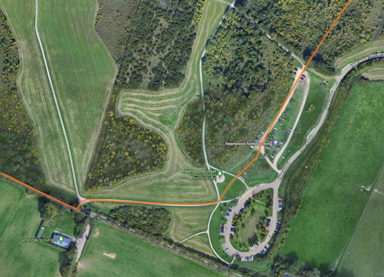
18: Turn left, leave the gravelled path, then head NE, walking just to the right of the information circle (pictured on the left on the photograph above). I have shown the route in orange on the map below.
 |
| The route past the main car park shown in orange |
Continue with the information circle on your left until you reach a track (location -
https://w3w.co/idea.cost.cable) leading to the overspill car park (location -
https://w3w.co/happen.leave.driven), see image below.
 |
| Follow the track leading to the overspill car park |
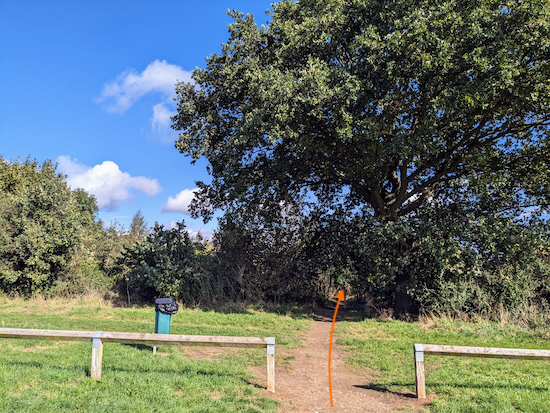
When you reach the overspill car park continue heading NE, now along a gravelled track, for 180m until you reach a junction and footpath in the hedgerow straight ahead (location -
https://w3w.co/deny.powers.luxury), see image below.
 |
| Follow the footpath as it weaves its way NE through young woodland |
19: Leave the overspill car park, cross the junction, then follow a pretty footpath as it weaves its way NE through young woodland for 270m before reaching a junction (location -
https://w3w.co/squad.skirt.scope), see image below.
 |
| Turn right at the junction then head E along a grassy track |
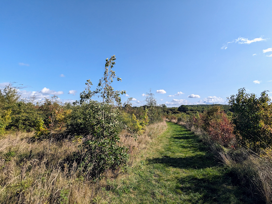
20: Turn right at the junction then head E along a grassy track.
 |
| Continue heading E along the grassy track until you reach a gate |
Continue for 260m until you reach a gate (location -
https://w3w.co/loses.spent.buns), see image below.
 |
| Go through the gate then turn left |
21: Go through the gate then turn left on Sandridge footpath 32. Don't be surprised if you come across cyclists and horse riders along this stretch of footpath. According to Hertfordshire County Council:
"Sandridge footpath 32 is recorded as a definitive footpath. The Woodland Trust owns the subsoil of approximately 95% of its length and allows bridleway use including cycle access. The remaining short middle section across Heartwood Manor’s drive is also a definitive footpath, but bridleway use is by permissive agreement with the land owner.
Follow Sandridge footpath 32 N for 870m until you reach the entrance to Nomansland Common (location -
https://w3w.co/fully.strut.jukebox), see image below.
 |
| Turn left off Sandridge footpath 32 |
22: Turn left off Sandridge footpath 32 then head NW for 275m until you reach two silver birch trees and a bench (location -
https://w3w.co/pine.matter.blaze) see image below.
 |
| Walk between the two silver birch then follow the path downhill |
23: Walk between the two silver birch then follow the path downhill and NW for 150m back to the car park and the starting point.
Interactive map


Just walked this today. Lovely walk. Found we got a little lost in Heartwood forest (Langley wood), I think we followed the wrong official path. But it’s easy enough to rectify the mistake using what3words.
ReplyDeleteSo glad you didn't get too lost and managed to find your way. And yes, the What3Words is a great help. If you haven't already done so please consider joining our friendly Facebook group where fellow walkers are sharing their walking experiences and photographs. David
Deletehttps://www.facebook.com/groups/hertfordshirewalker
Just completed the walk with friends prior to leading a walk in a few weeks. Very nice walk thanks with clear instructions as usual. Good mixture of terrain. Thanks, Brian.
ReplyDeleteGreat, glad you enjoyed the walk Brian.
DeleteIf you haven't already done so please consider joining our friendly Facebook group where fellow walkers are sharing their walking experiences and photographs. Invite your walking group members too. The more the merrier. :-)
David
https://www.facebook.com/groups/hertfordshirewalker
Lovely walk with a nice mix of woodland and fields. Be warned there are some VERY wet and muddy patches if you do it after heavy rain like we had this week ("Mud Lane" lives up to its name..!). Pipers Lane (instruction 5 to 6) was actually so flooded I had to do a small detour - a local was letting people go across his grounds but it's private land, so just got lucky he was passing and was willing to let people through.
ReplyDeleteOverall a great walk with really clear instructions.
Hi Laura, glad you enjoyed the walk despite the flooding, and thanks for the update - it will help other walkers. If you haven't already done so please consider joining our Hertfordshire Walker Facebook group where fellow walkers are sharing tips and photos from their walks in the Hertfordshire countryside.
Deletehttps://www.facebook.com/groups/hertfordshirewalker
I did reconnaissance of this walk today in preparation for leading a walking group next month. An excellent walk with a big problem in the middle - Cheapside Farm. The signage through the farm can't be faulted, but at present cows, calves and the bull are resident through the gate, and today they were straddled across the path. Unfortunately this path is crucial for crossing the Midland main line railway., but as a responsible walk leader, there is no way I can ask a group to take that risk. I retraced my steps to Ayres End Lane, and continued east for about 600 metres, crossing the railway and taking the first bridleway on the right into Heartwood Forest after that.
ReplyDeleteWell done navigating a detour round the problem at point 13. Do you think the cattle are a permanent or temporary problem? We had no problem when we tested and mapped the route before publishing.
DeleteI have no local knowledge of this farm, but if they rotate the herd with other fields then I would hope the problem would not be permanent.
DeleteHi really fancy trying this walk, but not sure if the distance. Can you tell me how many miles is it? Thank you
ReplyDeleteHi, if you scroll to the top of the page you will see the distance in miles and km. It's 6 miles (9.7 km) with 64m of total ascent. David
ReplyDelete