6.3 miles (10.1 km) with 72m of total ascent
 |
| The lake at point 15 in the walk |
This walk climbs out of the village of Stanstead Abbotts then crosses a high plateau of land before dropping down to the Stort Valley then returning through the picturesque lake area near Roydon Mill, and later cutting through a nature reserve alongside Abbotts Lake before returning to Stanstead Abbotts.
We have had several reports that the tunnel under the A414 at point 22 in the walk floods after heavy rain. This has been reported to the Hertfordshire County Council's Rights of Way team and they say they have drained the area. Several regular users of Hertfordshire Walker have suggested a detour, marked in orange on the map below if you need to avoid the flooded section.
Those wanting to travel by train for this walk could head for
St Margarets Station in Stanstead Abbotts then walk 700m to the starting point, or travel to
Roydon Station and join the walk at point 18.
There is a 130m section of this walk along the B181 north of Roydon Station where there is no pavement and very little verge to step onto to avoid oncoming traffic, although it was quiet when we walked it on a midweek morning. I would advise those walking with small children, dogs, or large walking groups to consider a different free walk from our growing collection.
There are a number of livestock fields along the way where there are signs asking dog owners to keep their pets on a lead.
Some footpaths are little used and you might have to push through nettles, so long trousers and a stick will come in handy.
Between points 11 & 12 you will pass the
Mosquito crew memorial at Olives Farm, Hunsdon.
Fly through preview of walk
If you want to check what sort of landscape you will be crossing before you set off on this walk you can view a short 3D video of the route below. It's created using the free version of
Relive.
Directions
 |
Map for Walk 244: Stanstead Abbotts South-East Loop
Click on the map above for a larger version
Created on Map Hub by Hertfordshire Walker
Elements © Thunderforest © OpenStreetMap contributors
There is an interactive map below these directions |
Those with GPS devices can download
GPX or
KML files for this walk. We've added
What3Words location references for those who use that system. If you print these walks you might want to use the green
PrintFriendly icon at the bottom of these directions to delete elements such as photographs.
 |
| The Red Lion, High Street, Stanstead Abbotts |
1: With your back to
The Red Lion, High Street, Stanstead Abbotts (location -
https://w3w.co/float.handed.doors), turn left then head E for 10m to a roundabout (location -
https://w3w.co/sunk.crops.images) where you turn left on Cappell Lane then head NE for 85m until you reach Abbotts Way on the right (location -
https://w3w.co/bought.option.torn), see image below.
 |
| Turn right on Abbotts Way |
Turn right on Abbotts Way then climb the hill heading ESE for 125m until you reach Chapelfields (location -
https://w3w.co/nobody.packet.flap).
Turn left on Chapelfields then head NNW for 15m looking out for a
footpath sign on the right (location -
https://w3w.co/thigh.shaped.bowls), see image below.
 |
| Follow Stanstead Abbotts footpath 6 up steps |
2: Follow Stanstead Abbotts footpath 6 up steps towards a row of houses. At the top of the steps (location -
https://w3w.co/voting.remind.noting) turn left then follow the path N then NE for 20m until you reach a footpath on the right cutting between the houses (location -
https://w3w.co/warns.splice.switch), see image below.
 |
| Follow Stanstead Abbotts footpath 6 between the houses |
Turn right between the houses, still on Stanstead Abbotts footpath 6, then head ENE for 50m until you reach a field (location -
https://w3w.co/tests.torn.arena).
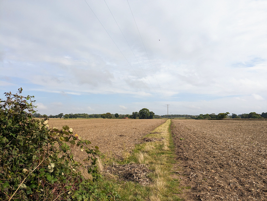
Follow the footpath round to the left, with the hedgerow on your left, until the footpath leaves the hedgerow then crosses a field (location -
https://w3w.co/name.passes.outfit), see image below.
 |
| Follow Stanstead Abbotts footpath 6 NE between the fields |
Follow Stanstead Abbotts footpath 6 NE between the fields for 475m until you reach a junction by a telegraph pole (location -
https://w3w.co/pound.nods.giant), see image below.
 |
| Keep heading straight at the junction |
3: Keep heading straight and NE at the junction for 185m, still on Stanstead Abbotts footpath 6, until you reach a gate leading to a
bridleway (location -
https://w3w.co/dating.dust.clues).
 |
| Turn right on Stanstead Abbotts bridleway 18 |
4: Turn right after the gate on Stanstead Abbotts bridleway 18 then head SSE for 90m looking for a footpath in the hedgerow on the left (location -
https://w3w.co/attend.escape.moss), see image below.
 |
| Turn left on Stanstead Abbotts footpath 6A |
5: Turn left on Stanstead Abbotts footpath 6A then head E for 900m until you reach woodland called Thirsty Spring on the left (location -
https://w3w.co/prefer.engage.ranked), see image below.
 |
| Follow Stanstead Abbotts footpath 6A as it turns right then left |
6: Continue with the woodland on your left. When you reach the end of the woodland (location -
https://w3w.co/proof.traded.lungs) follow Stanstead Abbotts footpath 6A as it bends right then left before running along the left hand side of another stretch of woodland.
Continue on Stanstead Abbotts footpath 6A, with the woodland on your right, for 215m until you reach a junction at the end of the woodland (location -
https://w3w.co/wisdom.cube.case), see image below.
 |
| At the end of the woodland turn right on Stanstead Abbotts footpath 28 |
7: At the end of the woodland turn right on Stanstead Abbotts footpath 28 then head SE for 200m with the woodland on your right until you reach a junction (location -
https://w3w.co/sleeps.cliff.line), see image below.
 |
| Turn right at the junction on Stanstead Abbotts footpath 22 |
8: Turn right at the junction on Stanstead Abbotts footpath 22 then head SW, SSE, SW, then S, with woodland and farm buildings on the right.
Along this stretch the footpath name changes from Stanstead Abbotts footpath 22 to Hunsdon footpath 25 as it crosses a parish boundary.
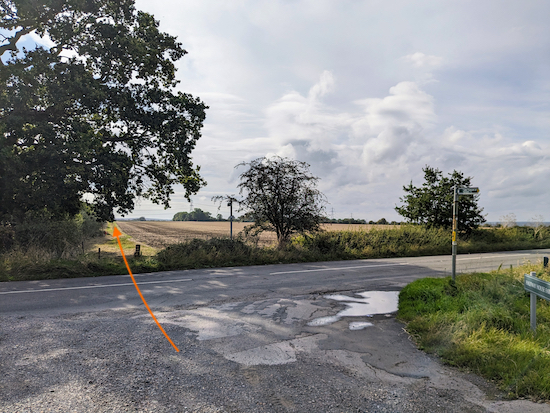
Continue for 390m until you reach Hunsdon Road, the B180 (location -
https://w3w.co/staple.cook.back), see image below.
 |
| Cross Hunsdon Road then take Hunsdon bridleway 23 |
9: Cross Hunsdon Road then take Hunsdon bridleway 23 and head S, with the hedgerow on your left, for 180m until you reach the end of the hedgerow (location -
https://w3w.co/nation.guitar.piles).
Continue heading S, still on Hunsdon bridleway 23, for 280m until you reach a stretch of woodland on your left called Square Spring (location -
https://w3w.co/surely.acting.amuse).
Keep heading S, with the woodland on your left, until you reach a junction at the end of the woodland (location -
https://w3w.co/hints.until.poetic), see image below.
 |
| Turn left at the end of the woodland |
10: Turn left at the end of the woodland then head E with the woodland on your left.
You are now on a bridleway which runs along a parish boundary and is both Hunsdon bridleway 23 and Stanstead Abbotts bridleway 21.
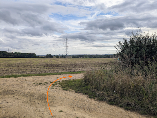
Continue heading E for 345m until you reach a junction (location -
https://w3w.co/fingernails.posed.globe), see image below.
 |
| When you reach the junction turn right |
11: When you reach the junction turn right on Hunsdon bridleway 2, then head SSW with the hedgerow on the right.
After 80m you will come across the
Mosquito crew memorial on the right (location -
https://w3w.co/tiles.admire.dozen), see images below.
 |
| The memorial along Hunsdon bridleway 2 |
 |
The plaque dedicated to Barney Jobling and Fred Weston
Click on image for a larger version |
The text on the memorial reads:
ON THE AFTERNOON OF 31ST AUGUST 1943 DH MOSQUITO NE MK2 DZ739 OF 157 SQUADRON BASED AT RAF HUNSDON CRASHED NEAR TO THIS SPOT DURING A SHORT NIGHT FLYING TEST PRIOR TO OPERATIONS THAT EVENING. BOTH CREW MEMBERS LOST THEIR LIVES. THIS PLAQUE IS DEDICATED TO PILOT P/OB.W. 'BARNEY' JOBLING AND NAVIGATOR P/O F.W. 'FRED' WESTON. REMEMBERED WITH PRIDE BY THEIR SONS AND FAMILIES. 'LEST WE FORGET'
Continue heading SSW then S on Hunsdon bridleway 2, with the hedgerow on the right, for 255m until the bridleway reaches a bend at the point where it crosses a parish boundary (location -
https://w3w.co/moves.play.super), see image below.
 |
| Head SSE on Stanstead Abbotts bridleway 2 |
12: Ignore the bend to the right then continue straight, now heading SSE on Stanstead Abbotts bridleway 20, with the hedgerow on the right, for 470m until you reach a tunnel under the A414 (location -
https://w3w.co/jumped.achieving.today), see image below.
 |
| Go through the tunnel under the A414 |
13: Pass under the A414, still on Stanstead Abbotts bridleway 20, then continue as the bridleway bends first left then right, with the hedgerow on the left, for 370m until it reaches an old metalled road (location -
https://w3w.co/filled.direct.pizza).
14: Turn left on the road then head E for 80m until you reach a footpath on the right (location -
https://w3w.co/stored.cable.each), see image below.
 |
| Turn right on Stanstead Abbotts footpath 13 |
Turn right on Stanstead Abbotts footpath 13 then head in SSE then S for 215m until you reach a lawned area with a sign which reads "KEEP CLOSE TO LAKE" (location -
https://w3w.co/drips.logic.oils), see image below.
 |
| Continue on Stanstead Abbotts footpath 13 with the lake on the left |
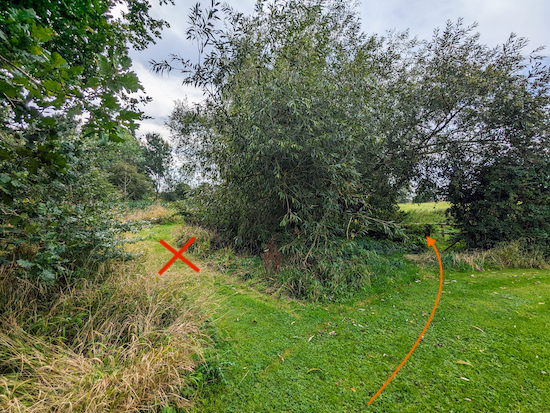
15: Continue on Stanstead Abbotts footpath 13, with the lake on the left and passing a willow tree on the right, (see orange arrow on the photograph above). After 80m you will reach a junction (location -
https://w3w.co/kept.extra.sunk), see image below.
 |
| Take the fork on the right |
16: Take the fork on the right (see orange arrow on the photograph above) as Stanstead Abbotts footpath 13 leaves the lake and heads SSW for 310m until it reaches a field (location -
https://w3w.co/filled.heave.finest), see image below.
 |
| Keep left at the field then follow Stanstead Abbotts footpath 13 SW |
17: Keep left at the field then follow Stanstead Abbotts footpath 13 SW for 465m until you reach the B181 (location -
https://w3w.co/career.verge.shout).
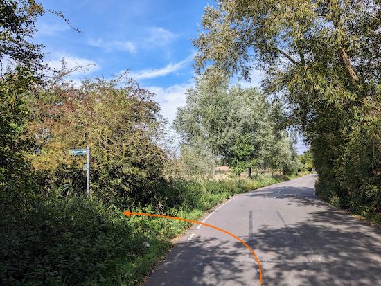
18: Turn right on the B181.
Unfortunately there isn't a pedestrian pavement along this short stretch, and nor is there a verge to step onto in case of traffic, so please take care and walk close to the hedge. Head NW for 130m until you reach a footpath on the left (location -
https://w3w.co/pets.feast.bunch), see image below.
 |
| Turn left off the B181 at a sign with two footpaths marked |
19: Turn left off the B181 at a post with two footpath signs, one heading to the right and the other heading straight ahead. You take the footpath heading straight ahead, see image below.
 |
| Head WSW on Stanstead Abbotts footpath 10 |
Head WSW on Stanstead Abbotts footpath 10 for 315m, with the River Stort on the left and telegraph poles on your right. Continue until you reach a bend in the river and a gate on the left (location -
https://w3w.co/start.spider.less), see image below.
 |
| Go through the gate, still on Stanstead Abbotts footpath 10 |
20: Go through the gate then continue heading ESE, still on Stanstead Abbotts footpath 10, for 650m until you reach a junction (location -
https://w3w.co/pirate.speak.unless), see image below.
 |
| Turn right at the junction on Stanstead Abbotts footpath 24 |
21: Turn right at the junction on Stanstead Abbotts footpath 24 then head N. After 40m you will reach a fork where Stanstead Abbotts footpath 24 cuts through thicket (location -
https://w3w.co/pencil.kinds.master), see image below.
 |
| Follow Stanstead Abbotts footpath 24 through the thicket |
Follow Stanstead Abbotts footpath 24 through the thicket and then across an open stretch for 185m until you reach Rye Road (location -
https://w3w.co/yappy.lots.frock).
 |
| Stanstead Abbotts footpath 24 approaching Rye Road |
22: Cross Rye Road then follow Stanstead Abbotts bridleway 19 NW for 200m until you come to an underpass beneath the A414 (location -
https://w3w.co/rally.tight.vouch), see image below.
 |
| Follow Stanstead Abbotts bridleway 19 through the underpass |
We have had several reports on our Hertfordshire Walker Facebook group that the tunnel under the A414 at this point floods after heavy rain. This has been reported to the Hertfordshire County Council's Rights of Way team. The council has since carried out drainage repairs. Several regular users of Hertfordshire Walker have suggested a detour which is marked in orange on the map below if the underpass floods again.
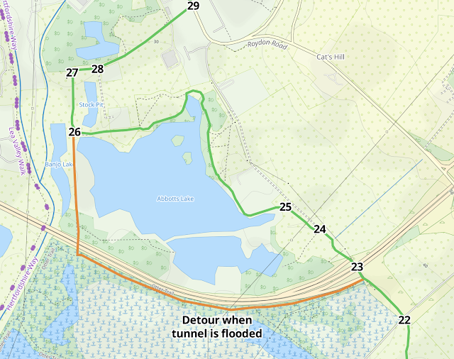 |
| The detour is marked in orange |
23: Continue through the underpass, still on Stanstead Abbotts bridleway 19. Head NW for 155m after the underpass, still on Stanstead Abbotts bridleway 19, until you reach a gate on the left (location -
https://w3w.co/rested.gets.reply), see image below.
 |
| Go through the gate then enter a nature reserve |
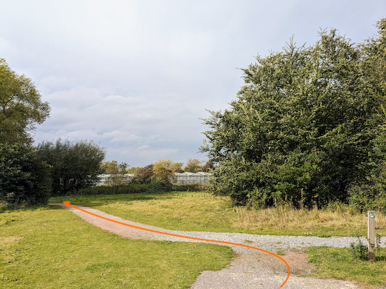
24: Go through the gate then enter a nature reserve. Turn right once through the gate then head NW for 125m until you reach a junction (location -
https://w3w.co/light.circle.ahead), see image below.
 |
| Turn left at the junction then follow a gravelled track |
25: Turn left at the junction then follow a gravelled track as it twists and turns with a lake on the left then crosses some elevated wooden walkways and a wooden footbridge. Continue along this gravelled path for 1k until you reach a road junction (location -
https://w3w.co/pool.proven.eaten), see image below.
 |
| Turn right at the junction then head N |
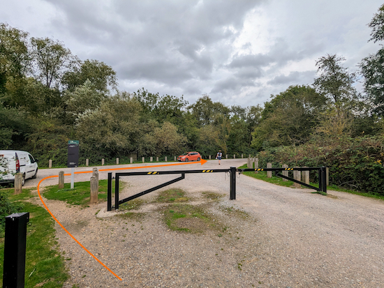
26: Turn right at the junction then head N for 180m to another junction and a parking area on the left (location -
https://w3w.co/activism.slide.client), see image below.
 |
| Turn right at the junction then head ENE |
27: Turn right at the junction then head E for 70m until you reach Marsh Lane (location -
https://w3w.co/flood.book.swim), see image below.
 |
| Turn left on Marsh Lane |
28: Turn left on Marsh Lane then follow it ENE for 345m until you reach Roydon Road (location -
https://w3w.co/heads.gates.parade).
29: Turn left on Roydon Road then head NNW for 365m back to the starting point.
Interactive map


Haven’t attempted this route yet but I’m a little confused about the underpasses and the suggested diversion. The commentary refers to the underpass at point 13 being possibly flooded but the diversion on the map seems to be about point 23.i.e. the homeward leg. Or have I missed something? Wouldn’t be the first time!
ReplyDeleteOops, thanks for pointing that out. It was a typo. Really sorry about that. I hope it hasn't put you off the walk. If you haven't already done so please consider joining our Hertfordshire Walker Facebook group where fellow-walkers are sharing tips and photos from their walks. David
Deletehttps://www.facebook.com/groups/hertfordshirewalker
Did this walk 9 Nov '25. I've notified David that the gate detailed in 2nd part of point 19 has been changed & moved to a slightly different location. It impacts on the instructions. You now go thro the gate on the left & turn right -ish . I strongly suspect David will check this out & correct the original & give better than 'rightish' details before too long. Thanks David
ReplyDeleteHi Christine, I have updated the directions to remove the reference to the second gate and encourage walkers to continue to follow Stanstead Abbotts footpath 10 to the next junction. Thanks for bringing it to my attention.
Delete