4.6 miles (7.4 km) with 32m total ascent
 |
| Approaching point 24 near the end of the walk |
This walk is another in our collection of walks for those who want like to leave the car at home and travel by train. It starts and finishes at Welham Green Station and passes close to Brookmans Park Station, which is an alternative start and finish point.
About a third of the route is either through built-up areas (close to Welham Green Station) or along lanes and a road which has a pedestrian pavement. Because of this, dog owners might want to choose a different walk from the collection.
The walk passes The Woodman Inn at Water End and close to two other pubs along the way. There are cafes, restaurants, and shops in both Welham Green and Brookmans Park.
Fly through preview of walk
If you want to check what sort of landscape you will be crossing before you set off on this walk you can view a short 3D video of the route below. It's created using the free version of Relive.
Directions
 |
Map for Walk 19: Welham Green South Loop
Click on the map above for a larger version
Created on Map Hub by Hertfordshire Walker
Elements © Thunderforest © OpenStreetMap contributors
There is an interactive map embedded at the end of these directions |
Those with GPS devices can download
GPX or
KML files for this walk. We've added
What3Words references for those who use that system. If you print these walks you might want to use the green
PrintFriendly icon at the bottom of these directions to delete elements such as photographs.
1: After ascending the stairs from Welham Green Station platform (location -
https://w3w.co/evenly.bring.purely), turn left on Dixons Hill Road then head WSW from the bridge for 110m until you come to Holloways Lane on the left (location -
https://w3w.co/person.spits.alarm), see image below.
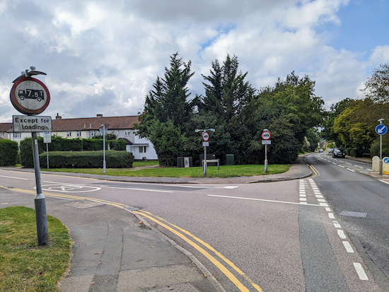 |
| Turn left on Holloways Lane |
Turn left on Holloways Lane then head S for 455m until you reach Bulls Lane (location -
https://w3w.co/focal.type.cubs). Turn right on Bulls Lane, see image below.
 |
| Turn right on Bulls Lane then left on Station Road |
2: After turning right on Bulls Lane head SW for 75m until you reach Station Road (location -
https://w3w.co/darker.grain.loads). Turn left on Station Road then head SSE for 55m until you reach a footpath on the right (location -
https://w3w.co/hurt.landed.transit), see image below.
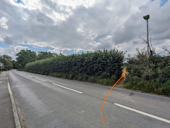 |
| Turn right on North Mymms footpath 8 |
3: Turn right on North Mymms footpath 8 then head SW across an arable field for 360m until you reach the hedgerow (location -
https://w3w.co/speaks.silly.poems).
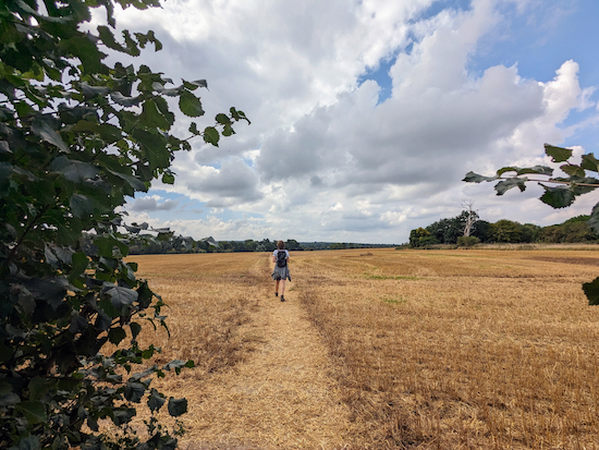 |
| Heading SW across an arable field on North Mymms footpath 8 |
 |
| After reaching the hedgerow keep heading straight |
After reaching the hedgerow keep heading straight, with the hedgerow on the left and the field on the right, for 100m, until the footpath you are on bends left then cuts through the hedgerow (location -
https://w3w.co/polite.even.letter), see image below.
 |
| Turn left, still on footpath 8 |
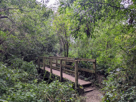
4: Turn left, still on North Mymms footpath 8, then head S for 50m crossing two footbridges until you reach a fork (location -
https://w3w.co/nerve.tennis.error), see images below.
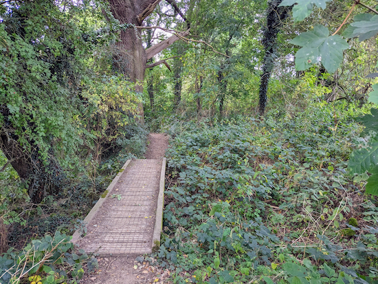 |
| North Mymms footpath 8 crossing the first footbridge |
 |
| North Mymms footpath 8 crossing the second footbridge |
 |
| Turn right at the fork after the second footbridge |
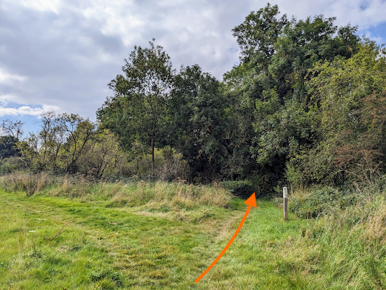
When you reach the fork after the second footbridge turn right then head SW for 65m until you emerge from a wooded area and reach a field (location -
https://w3w.co/ends.rarely.offer). Turn right at the field then head SW, now on North Mymms footpath 32, for 170m, with the hedgerow on the right and the field on the left, until you reach a footpath on the right (location -
https://w3w.co/guitar.forest.brick), see image below.
 |
| Turn right on North Mymms footpath 30 |
5: Turn right on North Mymms footpath 30 then head SW for 45m down to a footbridge (location -
https://w3w.co/modern.weeks.cage), see image below.
 |
| Cross the footbridge still on North Mymms footpath 30 |
Cross the footbridge, still on North Mymms footpath 30, then head SW and uphill for 80m until you reach a field (location -
https://w3w.co/leads.rewarding.rots) where you turn left, see image below.
 |
| Turn left at the field then head SW with the hedgerow on the left |
6: Turn left at the field then head SW, with the hedgerow on the left and field on the right, for 70m until the path bends right (location -
https://w3w.co/scars.sulk.piano). Continue, still on North Mymms footpath 30 but now heading W, for 100m until you reach a junction (location -
https://w3w.co/thigh.trim.doctor), see image below.
 |
| Turn left at the junction on North Mymms footpath 31 |
7: Turn left at the junction on North Mymms footpath 31 then head S then SW for 95m until you climb wooden stairs to reach a footpath (location -
https://w3w.co/nail.focal.stop).
8: Turn left on the footpath, which is also a cycle track, then head S, passing garages on the left. Continue for 115m until you reach the junction with Warrengate Road (location -
https://w3w.co/indeed.slowly.clip).
9: Turn left on Warrengate Road then head SSE. This is a narrow lane without a pedestrian pavement. After 75m you will pass
The Woodman Inn on the left (location -
https://w3w.co/laws.arrow.stick), see image below.
 |
| The Woodman Inn, Water End |
Continue heading SSE along Warrengate Road for 340m until you pass Bradmore Lane on the left (location -
https://w3w.co/acting.notes.orchestra).
10: Continue heading SSE, still on Warrengate Road, for another 200m looking out for a footpath on the left (location -
https://w3w.co/loaf.sharp.scope), see image below.
 |
| Turn left on North Mymms footpath 11 |
11: Turn left on North Mymms footpath 11 then cross a footbridge (location -
https://w3w.co/rare.finest.spent). If you are lucky you might see a kingfisher from the bridge. Continue along North Mymms footpath 11, now heading W, for 200m until you reach a footpath junction (location -
https://w3w.co/admire.poetic.gives), see image below.
 |
| Continue heading W, still on North Mymms footpath 11 |
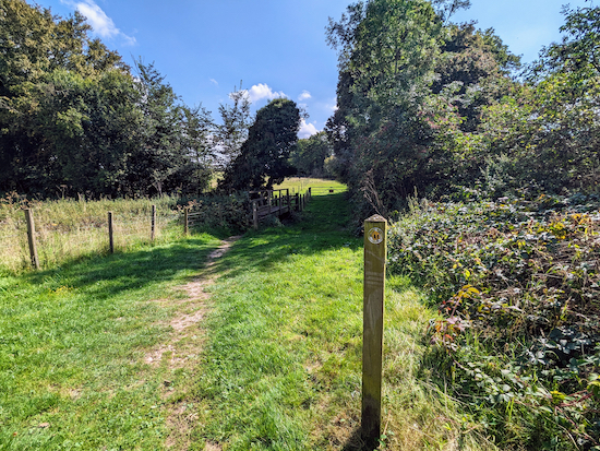
12: Ignore the footpath on the right and continue heading W, still on North Mymms footpath 11, for 315m until you reach a gate (location -
https://w3w.co/straw.yard.mute), see image below.
 |
| Go through the gate then turn right, see image below |
Go through the gate then turn right, still on North Mymms footpath 11, see image below.
 |
| After going through the gate head S to a footbridge |
13: After going through the gate head S to a footbridge. Cross the footbridge then turn left, still on North Mymms footpath 11, then head E, with the hedgerow on the left and field on the right. Continue for 320m until you reach a gate (location -
https://w3w.co/jets.swim.second), see image below.
 |
| Go through the gate then turn left on North Mymms footpath 9 |
14: Go through the gate then turn left on North Mymms footpath 9. Head NE and then N along this shaded path for 600m until you reach Station Road (location -
https://w3w.co/shakes.festivity.will)
 |
| Cross Station Road then turn left |
15: Cross Station Road then turn left and head NNW along the pedestrian pavement for 415m until you pass Potterells Medical Centre on the left (location -
https://w3w.co/brains.slams.impact). This used to be the lodge for
a large country house called Potterells.
16: This stretch of the walk is a bit boring because you will probably have to do it single file and there will probably be traffic. Continue along Station Road for another 385m until you pass St Thomas More Catholic Church on the right then reach a track, also on the right (location -
https://w3w.co/twins.upset.cherry), see image below.
 |
| Turn right then head NE for 65m until you reach a footpath |
17: Turn right then head NE for 65m until you reach a footpath straight ahead (location -
https://w3w.co/spite.linen.crate), see image below.
 |
| Follow the footpath SE for 30m until you reach a fork |
18: Follow North Mymms footpath 34 SE for 30m until you reach a fork (location -
https://w3w.co/amount.leans.boat), see image below.
 |
| Keep left at the fork then head uphill still on North Mymms footpath 34 |
Keep left at the fork and head uphill, still on North Mymms footpath 34, then follow the footpath NE for 350m until you reach Bulls Lane (location -
https://w3w.co/traps.sudden.films).
19: Turn right on Bulls Lane then head E for 100m, passing under a railway bridge then continuing until you reach a footpath on the right (location -
https://w3w.co/guises.transit.emerge) which heads E running parallel to Bulls Lane, see image below.
 |
| Turn right on North Mymms footpath 33 then head E |
20: Turn right on North Mymms footpath 33 then head E for 345m until you reach two footbridges (location -
https://w3w.co/jumpy.chill.asserts), see image below.
 |
| Take the footbridge on the left then turn right on Bulls Lane |
21: Take the footbridge on the left then turn right on Bulls Lane. Head E along Bulls Lane for 345m until you reach Foxes Lane on the left (location -
https://w3w.co/help.limbs.cheeks), see image below.
 |
| Turn left on Foxes Lane then follow it NW |
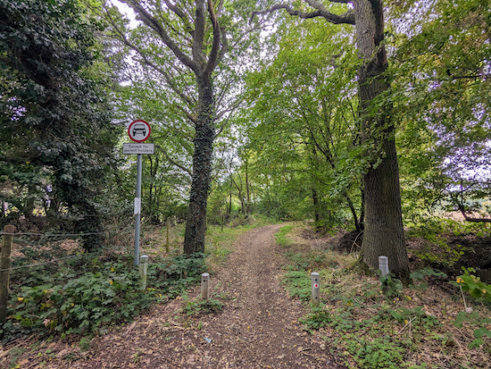
22: Turn left on Foxes Lane, which is also North Mymms BOAT 84 (byway open to all traffic) then follow it NW for 400m until Foxes Lane becomes a track (location -
https://w3w.co/woven.wide.proven), see image below.
 |
| Continue along North Mymms BOAT 84 |
Continue along North Mymms BOAT 84, first NW then N, for 300m until the byway bends left, see image below.
 |
| Continue on North Mymms BOAT 84, now heading W |
23: Continue on North Mymms BOAT 84, now heading W, for 325m until you reach a junction (location -
https://w3w.co/alarm.weeks.lanes), see image below.
 |
| Continue on North Mymms BOAT 84 |
23: Ignore the path on the right and continue on North Mymms BOAT 84 (see direction of orange arrow on the photograph above). You will now be heading NW on North Mymms BOAT 84. Continue for 195m until you reach Dixons Hill Road, Welham Green (location -
https://w3w.co/calms.buddy.sung)
24: Turn left on Dixons Hill Road then head SW for 60m to return to the starting point at Welham Green Station.
Interactive Map


Hi David, did this one today and had a good time. It was good you warned about the sections through the built up areas. They were my least favourite bits but nice to have a nosey at some houses every now and then! The rest was nice and quiet. Good mix of open spaces and woodland. Thanks!
ReplyDeleteHi Emma, yes, some loops involve some built up sections but it's nice to see that you deal with it with positive attitude :-). Glad you enjoyed the rest of the route. It's one close to our home and we walk those paths regularly.
Delete