7.4 miles (12 km) with 102m of total ascent
 |
Photograph taken along the route
Image courtesy of Norman Osland |
This is an excellent walk for those who like wide open uninterrupted views across undulating countryside. For most of the way the route follows well-defined tracks, although there are a few sections where footpaths cross arable fields which might be tough going after ploughing and before the paths are reinstated.
When we tested this walk on May 2, 2023, many fields had just been sprayed with
slurry in preparation for the growing season. We recommend you save this walk for a few weeks until the aroma has died down and rain has washed the fertiliser into the ground.
The route starts and finishes at Baldock Station, so for the first and last 10 minutes you will be walking in built-up areas. We have routed the return through the centre of
Baldock for those who want to see some of the interesting buildings in what is one of the few towns in Britain to have been "continually populated since prehistoric times".
 |
| Church Street, Baldock |
Between points 5 & 12 you will be aware of noise from the A505 Royston Road and the Cambridge to London railway line to the south-east, but this is compensated for by the wonderful sounds of the
skylarks overhead along most of the route.
Click here to hear the sound of the skylark.
Towards the end of the walk you will pass the entrance to the
Ivel Springs Nature Reserve (location -
https://w3w.co/bleat.freed.crazy) where there is an option to take a detour in order to visit the community run preservation project. The path through the reserve rejoins the main route further south.
We recommend taking a snack with you because there are no cafes or pubs along the way other than in Baldock at the start and finish point. There is a bench with southerly views on your left just after point 9 in the directions (location -
https://w3w.co/grownup.chuckling.thatched) if you want a place to sit down for your picnic.
Fly through preview of walk
If you want to check what sort of landscape you will be crossing before you set off on this walk you can view a short 3D video of the route below. It's created using the free version of
Relive.
Directions
 |
Map for Walk 229: Baldock NE Loop
Click here or on the map above for a larger version
Created on Map Hub by Hertfordshire Walker
Elements © Thunderforest © OpenStreetMap contributors
There is an interactive map below these directions |
Those with GPS devices can download
GPX or
KML files for this walk. We've added
What3Words location references for those who use that system. If you print these walks you might want to use the green
PrintFriendly icon at the bottom of these directions to delete elements such as photographs.
1: Exit
Baldock Station (location -
https://w3w.co/future.sprint.famed) then head S for 110m to Station Road (location -
https://w3w.co/wipe.inspector.trials). Turn right on Station Road then head NNW passing under the railway bridge and continuing for 195m until you reach Bygrave Road on the right (location -
https://w3w.co/stage.basket.jaws).
2: Turn right on Bygrave Road then head ENE then E for 345m until you reach a bridleway on the left (location -
https://w3w.co/tins.supply.rank), see image below.
Note: for the last 80m of this stretch there is no pavement, so you will need to step on a narrow grass verge to avoid traffic.
 |
| Head north on Baldock bridleway 34 |
3: Turn left on Baldock bridleway 34 then head N for 300m at which point the bridleway you are on crosses an arable field. At the point where the path bends to the right it crosses the parish boundary and becomes Bygrave bridleway 2 (location -
https://w3w.co/ballots.scans.wedge), see image below.
 |
| Baldock bridleway 34 becomes Bygrave bridleway 2 as it crosses a field |
4: Continue on Bygrave bridleway 2, now heading NNE, for 500m until you reach a junction (location -
https://w3w.co/rich.glows.nametag), see image below.
 |
| Turn right on Bygrave bridleway 1 |
5: Turn right on Bygrave bridleway 1, then head ENE for 1.2km until you reach Ashwell Road (location -
https://w3w.co/argue.sardine.skid).
6: Turn right on Ashwell Road then head SSE for 130m until you reach Wedon Way on the left. (location -
https://w3w.co/marmalade.glassware.clicker), see image below.
 |
| Turn left on Wedon Way |
7: Turn left on Wedon Way then head E then ESE for 410m until you pass the last house on the left where you join a track (location -
https://w3w.co/gulped.revealing.coached), see image below.
 |
| Turn left on Bygrave footpath 4 |
8: Turn left then head NNE on Bygrave footpath 4 for 230m until you reach a footpath on the right (location -
https://w3w.co/stage.nurtures.combining), this is the point where you will find a bench, see image below.
 |
| Turn right on Bygrave footpath 5 |
9: Turn right on Bygrave footpath 5 then head ESE for 315m until you reach a left-hand bend (location -
https://w3w.co/marathons.shuttle.celebrate), see image below.
 |
| Turn left on Bygrave footpath 6 |
10: Turn left on Bygrave footpath 6 then head NNE for 410m until you reach a track leading to Park Wood Lodge (location -
https://w3w.co/panoramic.ages.towels), see image below.
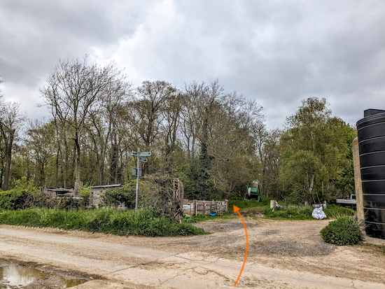 |
| Cross a track then head NNW, still on Bygrave footpath 6 |
11: Cross a track then head NNW, still on Bygrave footpath 6, and continue through Park Wood for 460m until you leave the woodland and reach a junction. (location -
https://w3w.co/seeing.width.that), see image below.
 |
| Turn right on Bygrave footpath 10 |
12: Turn right on Bygrave footpath 10 then head NE for 270m across an arable field until you reach a track (location -
https://w3w.co/boating.paintings.seasonal). Continue on the track, still on Bygrave footpath 10, for another 270m until you reach a footpath on the left which cuts through the crops (location -
https://w3w.co/iterative.sugar.imposes), see image below.
 |
| Turn left then head NW on Bygrave footpath 8 |
13: Turn left then head NW on Bygrave footpath 8 for 380m until you reach the edge of the field and a wooden footbridge over Cat Ditch. Cross the footbridge then turn left at a junction (location -
https://w3w.co/violinist.song.burns).
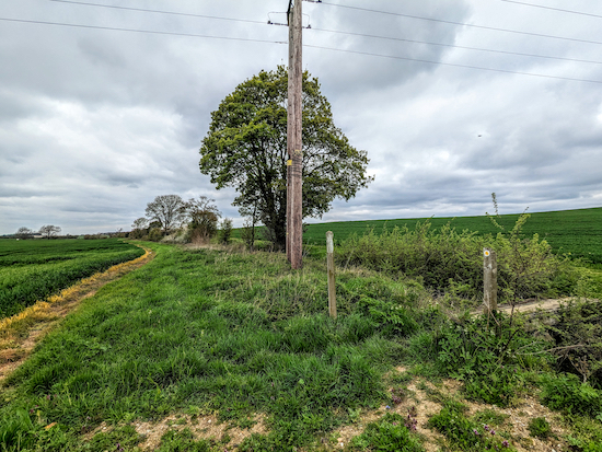 |
| Cross Cat Ditch then turn left on the bridleway |
14: Turn left on a bridleway which is both Bygrave bridleway 13 and Ashwell bridleway 4 then follow it NW for 325m until you cross Ashwell Road (location -
https://w3w.co/conjured.clapper.computer), see image below.
 |
| Cross Ashwell Road and continue on Bygrave bridleway 13 |
15: Cross Ashwell Road and continue heading NW, still on Bygrave bridleway 13, for 490m until the bridleway turns sharp left and heads S alongside a line of trees (location -
https://w3w.co/intensely.nips.wished), see image below.
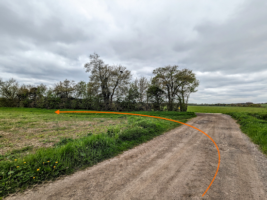 |
| Turn left before the line of trees on Bygrave bridleway 13 |
16: Turn left before the line of trees then follow Bygrave bridleway 13 S then SSW for 1.4km passing Bygrave Plantation on the right (location -
https://w3w.co/pass.yelled.finishers) and continuing until you reach a right-hand bend (location -
https://w3w.co/curiosity.unfounded.replays), see image below.
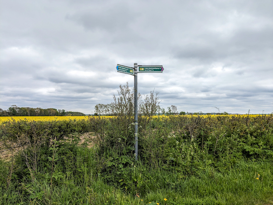 |
| Keep right, now on Bygrave restricted byway 14 |
17: Follow the track as it bends to the right. You are now on Bygrave restricted byway 14 which you follow SW for 2.2km until you reach North Road (location -
https://w3w.co/pizza.ridge.plan).
18: Cross North Road to reach the pedestrian pavement then turn left and head SSE for 160m until you reach a footpath on the right (location -
https://w3w.co/sling.wasp.swan), see image below.
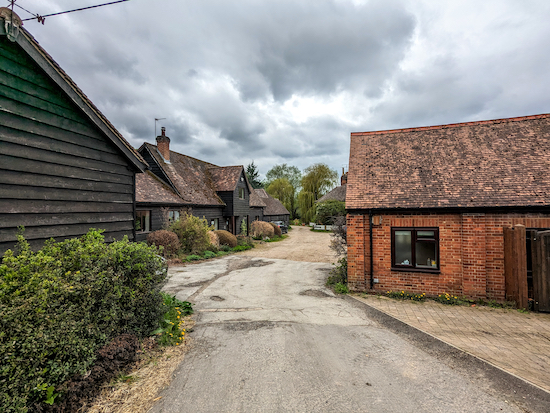 |
| Turn right on Baldock footpath 1 |
19: Turn right on Baldock footpath 1 then head W passing between two cottages, see image below.
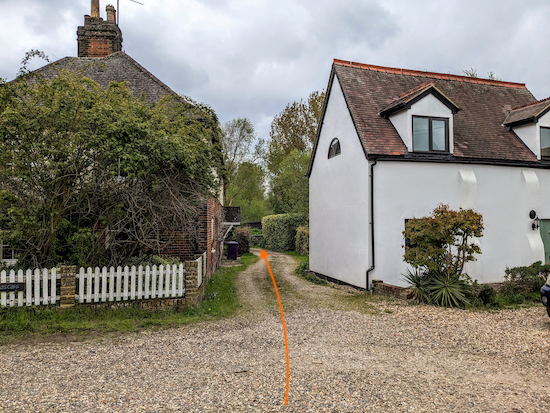 |
| Baldock footpath 1 passes between two cottages |
Continue on Baldock footpath 1 heading SW then S for 220m until you reach a staircase leading to the
Ivel Springs Nature Reserve on your left, see image below.
At this point you could take a detour through the reserve and rejoin the main route later. We have embedded some information and a map for the reserve at the foot of these directions. Click here for information about the reserve.
 |
| Staircase leading to the Ivel Springs Nature Reserve |
20: Continue on Baldock footpath 1 through a gate then turn left and head S for 360m crossing a livestock field where horses graze, and then passing stables on your right. Continue until you reach a footpath on the left, see image below.
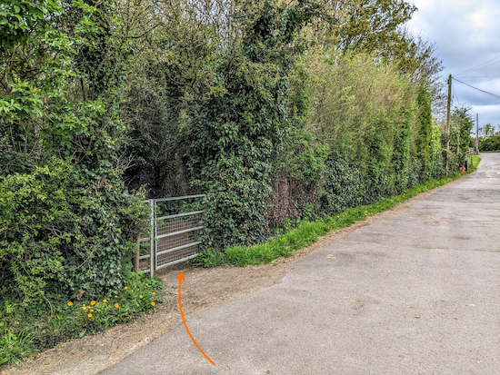 |
| Turn left, still on Baldock footpath 1 |
21: Turn left, still on Baldock footpath 1, then head E then SE for 240m until you reach a pedestrian tunnel under the railway line (location -
https://w3w.co/slate.slips.circle), see image below.
 |
| Head S through the pedestrian tunnel under the railway line |
22: Walk through the tunnel then continue for 85m until you reach a road called Icknield Way (location -
https://w3w.co/ruler.club.take).
* The Orange Tree pub/restaurant (location - https://w3w.co/remain.verge.twin) is 90m to the right when you join Icknield Way.
23: Turn left on Icknield Way then head E for 60m until you reach Church Street on the right (location -
https://w3w.co/player.sleep.human). Turn right on Church Street then head SE for 250m until you reach Sun Street on the left (location -
https://w3w.co/losses.happen.crowds).
24: Turn left on Sun Street then follow it NE for 75m, passing The Victoria (location -
https://w3w.co/aware.jazz.placed) on your left and continuing until you reach Whitehorse Street (location -
https://w3w.co/lime.speaks.cage).
Continue heading NE, now on Whitehorse Street, for 180m until you reach Station Road (location -
https://w3w.co/wiser.copy.jobs).
25: Turn left on Station Road then head NNW for 110m passing The Old White Horse (location -
https://w3w.co/hurry.boots.discrepancy) and The Engine (location -
https://w3w.co/harsh.pizza.oasis) on your left.
When you reach The Engine, cross Station Road then walk along Mallard Court (location -
https://w3w.co/nobody.fills.brings) back to Baldock Station and the end of the walk.
There are several pub, cafes and restaurants in Baldock. Apart from the pubs already mentioned there is The White Hart (location - https://w3w.co/apply.bumpy.level), The White Lion (location - https://w3w.co/defeat.skills.cards), and The Cock (location - https://w3w.co/agents.hoot.edge).
Interactive map
Literature about Ivel Springs Reserve


Lovely route David . Did this one this morning , plenty of mud which I was expecting . All paths clear until point 12 where the field has just been ploughed and at the moment it's impossible to walk across. Easy to walk round , as is the field at 13 which was fenced off and full of sheep today . Super stretch heading south past the airstrip - views fir miles. Mick
ReplyDelete