5.3 miles (8.4km) with 105m of total ascent
 |
| Kimpton bridleway 5 after point 14 |
This walk explores the rolling countryside to the SW of Kimpton, offering wide, open views. You will cross two arable fields which, when we tested this walk in November, had not yet been reinstated after cultivation. The route also includes two lengths of lane walking where there are no pedestrian pavements, but both sections have grass verges where you can step to one side if traffic approaches and both sections were quiet when we tested the route.
The walk starts and finishes outside
The Boot pub/restaurant on Kimpton High Street. Refreshments can also be purchased at Budgens close to point 2 in the walk.
Some of the paths will be muddy after rain, so strong, waterproof boots are recommended, and perhaps a stick because it can be slippy where footpaths and bridleways are muddy.
For dog walkers, we saw one sign along the way asking owners to keep their pets on a lead.
If you have youngsters walking with you who need to let off steam before or after the walk, there are two children's play areas. One is 275m E from the finishing point along High Street and on the right down a track (location -
https://w3w.co/ripe.rope.lift). The second is soon after the start of the walk on the right off bridleway 33 (location -
https://w3w.co/sadly.hello.award).
Fly through preview of walk
If you want to check what sort of landscape this walk covers before setting off you can view a short 3D video of the route below. It's created using the free version of
Relive.
Directions
 |
Route of Walk 222: Kimpton South-West Loop
Click on the map for a larger version
Map created on MapHub - copyright details here
There is an interactive map below the directions |
Those with GPS devices can download
GPX or
KML files for this walk. We've added
What3Words location references for those who use that system. If you print these walks you might want to use the green
PrintFriendly icon at the bottom of these directions to delete elements such as photographs.
Getting there
There are bus stops close to The Boot at the start of the walk which are served by the number 44, 45, 304, and 315 buses. You can check bus times at
Intalink.
There is a car park (location -
https://w3w.co/minus.glee.could), accessed via a track off Hitchin Road. The map below shows the route from the car park to the start/finish point.
 |
The route from the car park to the start point marked in blue
Map created on MapHub - copyright details here |
From the car park off Hitchin Road follow Kimpton
footpath 60 as it heads W, passing the tennis courts on your right and continues for 145m until it reaches Park Lane (location -
https://w3w.co/cooks.august.clips). Turn left on Park Lane then head S for 90m until you reach the junction with Parkfield Crescent (location -
https://w3w.co/gasp.panic.actors). Turn right then head SW, still on Park Lane, for 25m until you reach a junction (location -
https://w3w.co/pies.clocks.shirt). Keep left then head S, still on Park Lane, for 115m until you reach High Street (location -
https://w3w.co/tricky.breath.desks). Turn right on High Street then head W for 45m to reach The Boot on your right (location -
https://w3w.co/occurs.atomic.pops), see image below.
 |
| The Boot, High Street, Kimpton |
1: With your back to the Boot turn right then head W along High Street for 180m until you reach Claggy Road on the right (location -
https://w3w.co/just.pulled.along). Turn right on Claggy Road then head NW for 10m looking out for a
bridleway on the left just before the
Budgens store - which sells hot drinks and snacks (location -
https://w3w.co/wants.love.dive).
2: Turn left on Kimpton bridleway 33 then head W for 565m until you reach a road junction (location -
https://w3w.co/happy.them.folds), see image below.
 |
| Cross Fox Hill Road then take the permissive path |
3: Cross Fox Hill Road on your right then take the permissive path running alongside the N side of Kimpton Road (location -
https://w3w.co/throw.fight.boss), see image below.
 |
| Continue on the permissive path until you reach a footpath on the right |
Continue along this permissive path for 140m until you reach a footpath which turns right (location -
https://w3w.co/vote.encounter.valid), see image below.
 |
| Turn right on Kimpton footpath 37 then head NE |
4: Turn right on Kimpton footpath 37 and follow it NE as it crosses a field and then runs to the right of a line of hedgerow for 570m until it cuts across another field (location -
https://w3w.co/lime.pouch.woes), see image below.
 |
| Kimpton footpath 37 cutting across a field |
Continue on Kimpton footpath 37 until you reach Luton Road at a hamlet called
Ansells End (location -
https://w3w.co/badge.pies.fuzzy).
5: Turn left on Luton Road then head NW for 45m to a junction (location -
https://w3w.co/sketch.toast.store), see image below.
 |
| When you reach the junction keep left |
When you reach the junction keep left then head W then SW along a quiet lane for 645m until you reach Kimpton Road (location -
https://w3w.co/fees.foster.settle). There is no pedestrian pavement along this stretch but there is a grass verge for most of the way offering a place to step aside if you meet traffic.
6: Turn right on Kimpton Road then head WNW for 95m looking for a bridleway on the left (location -
https://w3w.co/line.cups.flank), see image below.
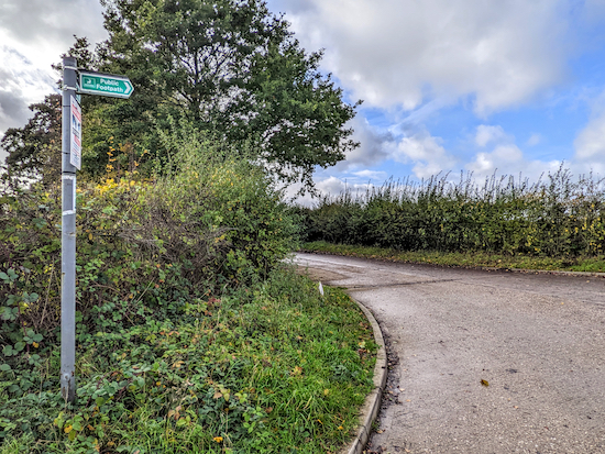 |
| Turn left on Kimpton bridleway 59 |
Turn left on Kimpton bridleway 59 then head S for 260m until the bridleway bends right (location -
https://w3w.co/slim.peanut.club) at Ramridge Farm. Head WSW for 25m until you reach a barn and a bridleway on the left (location -
https://w3w.co/list.become.sport). At this point the bridleway you are on becomes Kimpton bridleway 41 and heads S, see map below of route through farmyard below.
 |
The public right of way through Ramridge Farm
Map created on MapHub - copyright details here |
7: Continue heading S on Kimpton bridleway 41 for 275m until you reach a footpath on the left at the end of a line of hedgerow (location -
https://w3w.co/slams.chins.snap), see image below.
 |
| Turn left on Kimpton footpath 42 |
8: Turn left on Kimpton footpath 42 then head ESE across a field for 115m until you reach a tree and a line of hedgerow on the other side (location -
https://w3w.co/future.eaten.flown), see image below. The path across this field had not been reinstated when we tested this walk in November 2022.
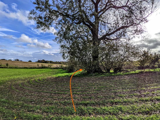 |
| Kimpton footpath 42 turns right after the tree |
Kimpton footpath 42 turns right after the tree then heads SSW for 250m, with the hedgerow on the right and field on the left, until you reach woodland and the footpath you are on crosses a parish boundary and becomes Wheathampstead footpath 98 (location -
https://w3w.co/shakes.usage.grow). Continue now heading S on Wheathampstead footpath 98 for 155m until you reach a footpath T-junction (location -
https://w3w.co/friend.occupy.nation), see image below.
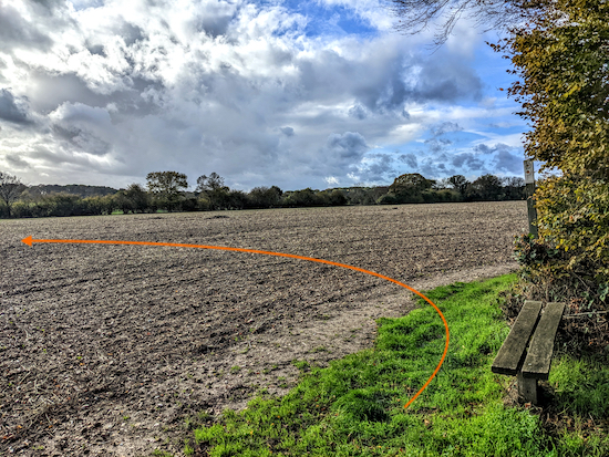 |
| Turn left on Wheathampstead footpath 83 |
9: Turn left on Wheathampstead footpath 83, then head E for 270m where you will cross a parish boundary in the middle of a field (location -
https://w3w.co/faster.note.agenda), see image of route below.
 |
| Continue across the field, now on Kimpton footpath 49 |
Continue across the field, now on Kimpton footpath 49 and heading E for 175m until you reach the hedgerow (location -
https://w3w.co/galaxy.divisions.stream), see image below.
 |
| Kimpton footpath 49 bends right then heads SSE across the field |
At the hedgerow Kimpton footpath 49 bends right then heads SSE for 90m before reaching a road called Kimpton Bottom (location -
https://w3w.co/cheeks.pound.plus), see image below.
 |
| Follow Kimpton bridleway 52 SSE |
10: Cross Kimpton Bottom and take the bridleway on the other side of the road, Kimpton bridleway 52, then head SSE then SSW for 665m until you cross a parish boundary (location -
https://w3w.co/milk.year.atomic), and the bridleway you are on becomes Wheathampstead bridleway 31 which you follow SSW for 285m until you reach Holly Lane (location -
https://w3w.co/slot.clever.gloves).
11: Turn left on Holly Lane then head S for 45m to reach Sauncey Wood Lane (location -
https://w3w.co/tides.puff.scenes). Turn left on Sauncey Wood Lane then head E then SE for 300m until you reach a junction (location -
https://w3w.co/fear.views.ever), see image below.
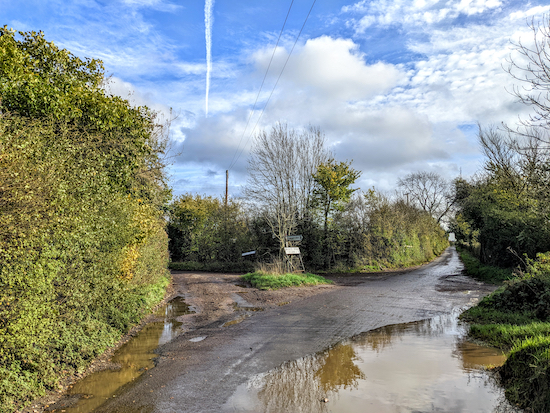 |
| Turn left on Porter's End Lane |
12: Turn left on Porter's End Lane. This next section of lane doesn't have a pedestrian pavement, but there are grass verges where you can step aside if traffic approaches. Follow Porter's End Lane NW for 1.2km until you reach a footpath on the right (location -
https://w3w.co/gangs.mull.eager), see image below.
 |
| Turn right on Kimpton footpath 48 |
13: Turn right on Kimpton footpath 48 then head SE for 370m until the path bends left (location -
https://w3w.co/fine.sleepy.swaps), see image below.
 |
| Kimpton footpath 48 heading to Kimpton Road |
Kimpton footpath 48 now heads ENE for 200m to Kimpton Road (location -
https://w3w.co/motel.advice.drops), see image below.
 |
| Cross Kimpton Road then take Kimpton bridleway 5 |
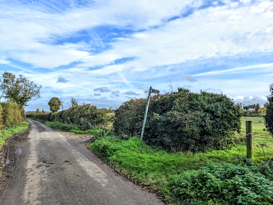
14: Cross Kimpton Road then take the bridleway on the opposite side, Kimpton bridleway 5. The bridleway turns right once through the hedgerow then heads SE for 15m before reaching a hedgerow then bending left (location -
https://w3w.co/skinny.deeply.hatch), see image below.
 |
| Kimpton bridleway 5 bends left then heads NE |
Keep left then head NE on Kimpton bridleway 5, with the hedgerow on the right, for 540m to a junction (location -
https://w3w.co/talent.danger.report), see image below.
 |
| Continue heading NE then N on Kimpton bridleway 5 |
Cross the junction then continue heading NE then N on Kimpton bridleway 5 for 640m back to Kimpton High Street (location -
https://w3w.co/pepper.trace.stable) where you will see the Boot and the start/finish point of the walk across the road on the right (location -
https://w3w.co/crop.local.could).
Interactive map


No way mark at point 9 indicating direction of path 83 across field. The path was ploughed out across field so hard to follow. We did see raven and heard tawny owl in wood though 🙂 steve & ann
ReplyDeleteThanks for the feedback Steve and Ann,
DeleteThere is a post at that point but it is obscured by hedgerow just south of the bench (have a closer look at the image above point 9 and you will spot it). It would be much better if the marker post was placed before the bench. And yes, the path is hard to follow having recently been ploughed (a common problem this time of the year), which is why I added the orange line on the image below showing my wife Ellie walking across the field and the direction walkers should take. It's always difficult describing the route when fields have been cultivated which is why I recommend downloading the free GPX files for those with smartphones.
I hope it didn't spoil your walk. Thanks again for taking the time to report back.
Dave
The walk was great we thoroughly enjoyed it. We saw the way mark post but not the arrow pointing the way. Steve
ReplyDeleteAh, got it. I sometimes find the arrows misleading. I am Interested that you heard a tawny owl. Do you use an appt to identify the call or do you just know? I use BirdNet.
DeleteI know the call. Twit twooo. We just heard the twooo part of the call which is made by the male tawny owl. It was surprising to hear it in the day. Steve.
ReplyDeleteWonderful, I wish I had that skill.
DeleteHi Dave another Brilliant Kimpton Walk . Footpaths , Open Fields , Lanes had everything . Thanks for all the directions . Ok the field umm , got across Ok plus it was dry yippee and a lovely sunny day with slight chill in the wind . Thanks . Ian R .
ReplyDeleteHi Ian, glad you enjoyed it. Thanks for the feedback. What was the problem with the field? Dave
DeleteHi Dave it was point 9 I obviously did not put enough bend on direction and finished up opposite the Blue Cross Centre, not a big problem .
ReplyDelete