5.7 miles (9.2 km) with 128m of total ascent
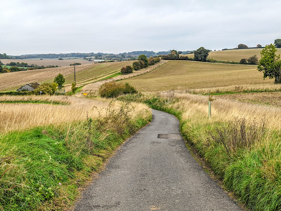 |
| The route between points 14 & 15 |
This is a great walk if you don't mind quite a bit of up and down; the reward is being treated to some wide open views across the rolling north Hertfordshire countryside. The climb along a bridleway from Dane End to Whitehill is one of the steepest in our collection of walks, but the panoramic views when you reach the top are worth it.
The route runs along the edge of a golf course and crosses one fairway. There are some signs along the way asking dog owners to keep their pets on a lead. You will pass livestock fields.
The starting point for the walk is 3.6 miles NE from Watton-at-Stone Station by road. Little Munden Parish Council has kindly given permission for walkers to use their free car park at Dane End.
A couple of paths on this route might be familiar for regular users of our site because we have walked them before but in the opposite direction.
Fly through preview of walk
If you want to check what sort of landscape this walk covers before setting off you can view a short 3D video of the route below. It's created using the free version of
Relive.
Directions
 |
Walk 218: Dane End South-East Loop
Click here or on the map for a larger version
Created on Map Hub by Hertfordshire Walker
Elements © Thunderforest © OpenStreetMap contributors
There is an interactive map below the directions |
Those with GPS devices can download
GPX or
KML files for this walk. We've added
What3Words location references for those who use that system. If you print these walks you might want to use the green
PrintFriendly icon at the bottom of these directions to delete elements such as photographs.
Park in the
Little Munden Parish Council car park at the junction of Whempstead Lane and Munden Road (location -
https://w3w.co/pepper.warm.lasts). I have spoken to the parish council and they say walkers are welcome to park there.
 |
| The Boot, Munden Road, Dane End |
1: From the car park turn left then head ENE for 600m, passing
The Boot on the left (location -
https://w3w.co/flies.suits.swept) and continuing until you reach a
bridleway on the right (location -
https://w3w.co/enter.distorts.spooned), see image below.
If you want to avoid walking along this stretch of road you could take a short footpath on the left of the road which runs parallel. It starts at Windy Rise (location - https://w3w.co/date.tissue.motoring), and ends at Church Lane (location - https://w3w.co/bachelor.stockpile.aims) where you turn right to join the footpath below.
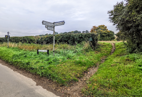 |
| Turn right on Little Munden bridleway 11 |
2: Turn right on Little Munden
bridleway 11 then head SE and uphill. You will cross a footbridge (location -
https://w3w.co/desktop.imported.hothouse), then continue climbing steeply for 620m along a lovely track.
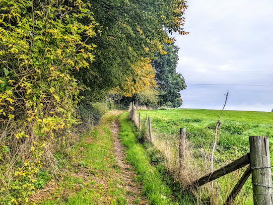 |
| Part of the steady climb uphill on Little Munden bridleway 11 |
It's worth pausing along this stretch in order to look back to enjoy the views as you rise above Dane End.
3: Turn right on a lane called Whitehill then head SE for 50m looking for a
footpath on the right (location -
https://w3w.co/mile.spend.flame), see image below.
 |
| Turn right on Little Munden footpath 15 |
Turn right on the
Whitehill Golf drive, which is also Little Munden footpath 15, then head SSW for 290m until you reach a car park on the right (location -
https://w3w.co/these.alien.before) and a gate slightly to your left, see image below.
 |
| Continue heading SSW on Little Munden footpath 15 |
Little Munden footpath 15 continues, now heading SSE beyond the gate, for 115m until it reaches a footpath junction (location -
https://w3w.co/gallons.drops.city), see image below.
 |
| Turn left on Little Munden footpath 6 then head E |
4: Turn left on Little Munden footpath 6 then head E for 140m, with the golf course on the right and the woodland on the left, until the footpath cuts to the left through woodland (location -
https://w3w.co/shade.every.head), see image below.
 |
| Follow Little Munden footpath 6 into the woodland |
Continue through the woodland, still heading E along the edge of the golf course. After 190m you will leave the woodland and reach a golf green on your right (location -
https://w3w.co/energetic.cross.chins). Continue, still on Little Munden footpath 6 and still heading E, to a gap in the hedgerow (location -
https://w3w.co/this.teach.from) see image below.
 |
| Little Munden footpath 6 crossing the golf course |
Continue heading E, still on Little Munden footpath 6, for 95m until you reach a fairway (location -
https://w3w.co/silver.small.paint) where you need to look to your left to check for golfers. This is the only fairway you will cross on this walk. Continue heading E for 75m until you reach a lane called Whitehill (location -
https://w3w.co/youth.crash.flute), see image below.
 |
| Turn right on Whitehill then left take the footpath on the left |
5: Turn right on Whitehill then head SE for 15m looking for a footpath on the left (location -
https://w3w.co/alone.deal.sage). Turn left, still on Little Munden footpath 6, and head E through woodland for 85m, going through a gate and crossing a footbridge before reaching a field (location -
https://w3w.co/calls.likely.losses).
When you reach the field head ESE, with the hedgerow on the left and field on the right, for 150m until you reach a gate (location -
https://w3w.co/arena.piles.unique). Go through the gate then turn diagonally to your right and head SE for 105m to a junction and a gate (location -
https://w3w.co/sooner.divide.plans), see image below.
 |
| Turn right on Little Munden footpath 25 |
6: Turn right on Little Munden footpath 25 then head SW for 20m to a junction (location -
https://w3w.co/even.shave.soda) at which point the path you are on becomes Little Munden BOAT 25 (
byway open to all traffic), which you follow for 90m heading SSW until you reach Whitehill again (location -
https://w3w.co/cake.repair.dices), see image below.
 |
| Turn right on Whitehill then head NW |
7: Turn right on Whitehill then head NW for 55m until you reach a lane on the left (location -
https://w3w.co/either.fault.crush), see image below.
 |
| Turn left on Rowney Lane then follow it SW |
Turn left on Rowney Lane. There isn't a pedestrian pavement along this stretch of quiet lane, but there is a verge where you can step to one side to avoid traffic. Follow Rowney Lane SW for 970m until you reach a junction (location -
https://w3w.co/stud.chats.songs), see image below.
 |
| Rowney Lane heading WSW towards the footpath on the left |
8: Turn right, still on Rowney Lane, head WSW for 70m until you reach a footpath on the left (location -
https://w3w.co/loans.shield.basket), see image below.
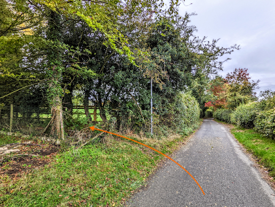 |
| Turn left on Sacombe footpath 2 |
9: Turn left on Sacombe footpath 2 then follow it SSE for 40m then WSW for 305m, passing a Christmas tree farm on the left and continuing until you reach Marshall's Lane (location -
https://w3w.co/list.candle.shapes).
10: Turn right on Marshall's Lane then head WNW for 80m to a junction (location -
https://w3w.co/income.tins.ending). Turn left at the junction then head S for 25m until you reach another junction (location -
https://w3w.co/dollar.ranch.when), see image below.
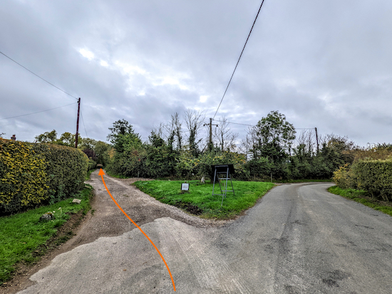 |
| Turn left on Sacombe bridleway 4 |
11: Turn left on Sacombe bridleway 4 then head SSE then SW for 505m until you reach a bridleway junction (location -
https://w3w.co/games.softly.yours), see image below.
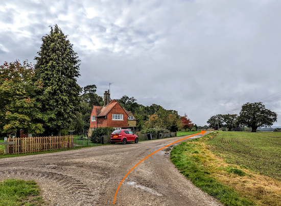 |
| Turn right on Sacombe bridleway 5 |
12: Turn right on Sacombe bridleway 5 then follow it WSW for 510m until you reach a bridleway junction (location -
https://w3w.co/stale.latest.hook), see image below.
 |
| Turn right on Sacombe bridleway 12 |
13: Turn right on Sacombe bridleway 12 then head N for 400m until you reach St Catherine's Church on the right (location -
https://w3w.co/pinks.scales.waving), see image below.
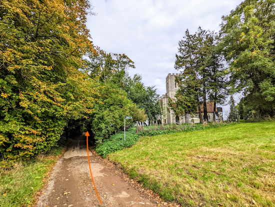 |
| Head N along Sacombe Church Road |
14: Pass the church on the right then continue heading N along Sacombe Church Road for 70m to a bend then head W for 60m to another bend then N for 215m until you reach Sacombe Green Road (location -
https://w3w.co/pints.exchanges.effort), see image below.
 |
| Cross Sacombe Green Road then head N on Sacombe footpath 8 |
15: Cross Sacombe Green Road then head N on Sacombe footpath 8 for 750m at which point the path doglegs left then right as you cross a parish boundary (location -
https://w3w.co/trunk.paid.mount), see image below.
 |
| Continue heading N, now on Little Munden footpath 26 |
16: Continue heading N, now on Little Munden footpath 26, for 350m until the footpath forks to the right (location -
https://w3w.co/stays.salads.slams), see image below.
 |
| Follow Little Munden footpath 26 NE |
17: Follow Little Munden footpath 26 NE for 170m, with the hedgerow on the right and field on the left, until you reach a gap in the hedge where the footpath turns right (location -
https://w3w.co/credit.prep.complains), see image below.
 |
| Turn right as Little Munden footpath 26 goes through a gap |
18: Turn right then follow Little Munden footpath 26 through the gap in the hedgerow, up a set of steps then across a field and continue heading E for 345m until you reach a farmyard (location -
https://w3w.co/treat.reap.device), see map below for the route through the farmyard.
 |
The route through the farmyard
Image courtesy of: SSource: Esri, DigitalGlobe, GeoEye, Earthstar Geographics,
CNES/Airbus DS, USDA, USGS, AEX, Getmapping, Aerogrid, IGN,
IGP, swisstopo, and the GIS User Community |
19: Head E then SE through the farmyard with stables on your right and left for 90m, still on Little Munden footpath 26, then follow the farm track as it bends left (location -
https://w3w.co/wing.backup.credit) then heads NE for 160m to a right turn with a footpath on the left (location -
https://w3w.co/rising.verbs.prefer), see image below.
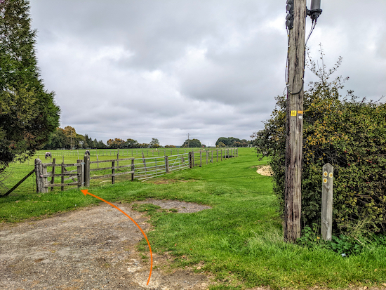 |
Turn left on Little Munden footpath 6
|
20: Turn left on Little Munden footpath 6 then follow it NW then W for 350m until you reach a line of hedgerow (location -
https://w3w.co/chained.audio.level), see image below.
 |
| Little Munden footpath 6 continues to the right of the hedgerow |
21: Little Munden footpath 6 continues to the right of the hedgerow (see orange arrow on the image above) then heads NW for 150m before reaching a gap in the hedgerow on the left (location -
https://w3w.co/deed.blaze.encounter), see image below.
 |
| Follow Little Munden footpath 6 through the gap |
22: Follow Little Munden footpath 6 through the gap then head W and downhill for 470m until you reach Munden Road (location -
https://w3w.co/skip.broken.space).
23: Turn right on Munden Road then head N for 150m back to the car park and the starting point.
Interactive map


Did this walk today and really enjoyed it! Very varied with great views and lots of interesting stuff to look at. Added bonus: a bench with a view - perfect for a lunch stop - in St Catharine’s churchyard, just off the route at points 13/14.
ReplyDeleteMany thanks!
Hi Janet and Nick, glad you enjoyed it. And thanks for sharing the tip about the bench. David
DeleteThank you for sharing another lovely walk. Easy to follow and very enjoyable.
ReplyDeleteExcellent, so glad you enjoyed it. We did too. Thanks for taking the time to share you feedback. David
DeleteAnother excellent, varied walk with clear instructions. It was surprisingly dry underfoot despite the torrential rain we had yesterday. Thank you David.
ReplyDeleteHi Beryl, glad you enjoyed the walk; we did, too. David
DeleteGreat walk, thanks. Herd of fallow deer seen at point 22. Cheers Steve and Ann
DeleteWow, you were lucky. Was it okay underfoot?
DeleteFine with walking boots
ReplyDeleteGlad you had walking boots; I wouldn't advise attempting any of our walks without proper boots. Hope you enjoyed it.
DeleteLovely walk and views. Instructions are very good also the arrows make it easier to follow. Unfortunately we went wrong just after St Catherine Church 14/15. We wasn't sure to keep to the road or go on the pathway. We went on the pathway which wasn't the correct way to do. An arrow on the Instructions would have helped. What a fantastic app. Thank you for lots of enjoying walks
ReplyDeleteGlad you enjoyed the walk despite a minor blip. I will check the instructions and see if I can add an arrow. Thanks for the feedback.
DeleteWalked this today. Great route, thank you!
ReplyDeleteGlad you enjoyed it Chris.
Delete