4.7 miles (7.6 km) with 84m of total ascent
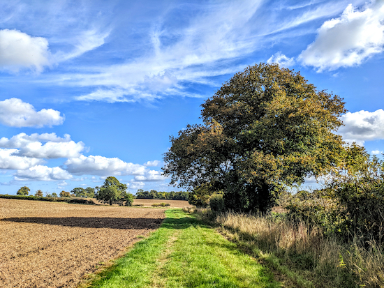 |
| Standon footpath 27 between points 12 & 13 |
This walk explores the open countryside west of
Puckeridge following well-defined rights of way offering great views. You will cross livestock fields, and there are signs along the way asking dog owners to keep their pets on leads. The starting point is from the car park in Puckeridge village which is seven miles NNE from Ware Station by road. The route involves crossing the A10 Puckeridge bypass twice.
Getting there
There are bus stops (location -
https://w3w.co/elbow.shiny.mega) close to the start of the walk which are served by the number 36, 36A, 331, 331, 386, and 831 buses. You can check bus times at
Intalink.
Fly over the route before you set off
If you want to check what sort of landscape this walk covers before setting off you can view a short 3D video of the route below. It's created using the free version of
Relive.
This walk crosses the A10 dual carriageway twice, once on the way out and once on the way back. Each crossing has a grass verge between the carriageways. When we tested this walk there was no problem crossing. However, those walking with small children or dogs, older walkers who might not walk that quickly, or walking groups might want to pick a different walk. You will also cross a livestock field where we saw a 'Bull in field' notice as we exited the field. We didn't see a bull although we did meet some inquisitive young cattle.
Directions
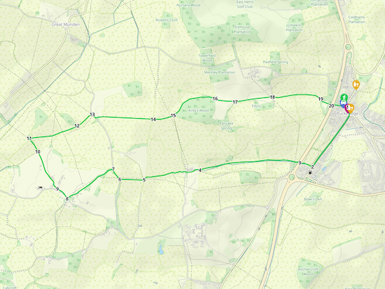 |
Walk 216: Puckeridge West Loop
Click here or on the map for a larger version
Created on Map Hub by Hertfordshire Walker
Elements © Thunderforest © OpenStreetMap contributors
There is an interactive map below the directions |
Those with GPS devices can download
GPX or
KML files for this walk. We've added
What3Words location references for those who use that system. If you print these walks you might want to use the green
PrintFriendly icon at the bottom of these directions to delete elements such as photographs.
 |
| Huntsman Close meeting High Street |
1: Exit the public car park (which was free at time of writing 11 October 2022) off Huntsman Close (location -
https://w3w.co/timed.mammoths.sweated) then turn right and head E for 45m until you reach High Street (location -
https://w3w.co/solar.dripping.modem).
 |
| The Crown and Falcon, High Street, Puckeridge |
Turn right on High Street then head SW for 75m passing
The Crown and Falcon (location -
https://w3w.co/clotting.cured.loft) on your left.
Continue heading SW along High Street for 360m until the road becomes Cambridge Road (location -
https://w3w.co/force.snored.fishnet). Keep heading SW, now on Cambridge Road, for 320m until you reach a footpath on the right (location -
https://w3w.co/recliner.shelters.detonated), see image below.
 |
| Turn right on Standon footpath 26 |
2: Turn right on Standon
footpath 26 then head W for 130m until you reach the A10 Puckeridge bypass (location -
https://w3w.co/remain.latest.heaven).
As you approach the A10 look right to check for traffic on the southbound lanes slowing down before reaching the roundabout on your left. Once you reach the grass verge halfway across look left to check for traffic speeding up on the northbound lanes after leaving the roundabout, then cross towards the footpath on the other side, see image below.
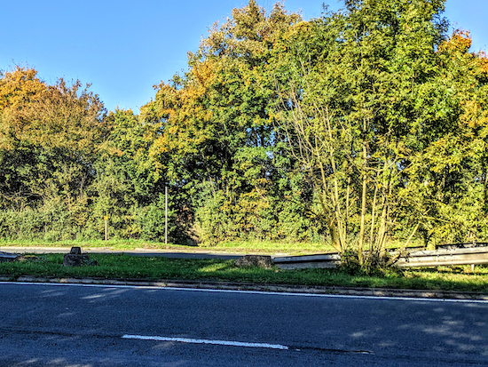 |
| The footpath crossing the A10 via a grass verge between carriageways |
3: Once across the A10 continue heading W on Standon footpath 26. This is a lovely stretch, see image below.
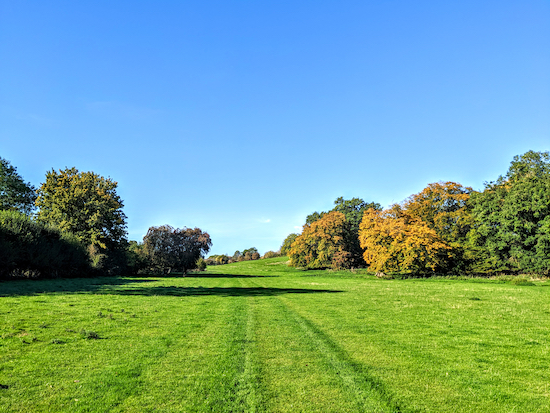 |
| Standon footpath 26 heading W towards Hole Farm |
Continue on Standon footpath 26 for 1km until you reach a gate leading to Hole Farm (location -
https://w3w.co/vast.condensed.scrapping), see image below.
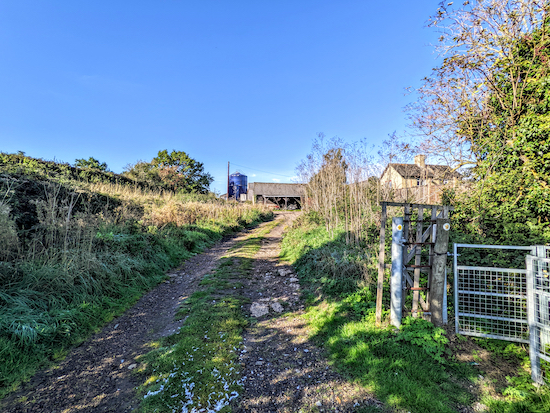 |
| The gate leading to Hole Farm |
4: Go through the gate then continue heading W, still on Standon footpath 26, first through the farmyard and then along the edge of a field with the hedgerow on the right and the field on the left for 550m until the path bends to the left (location -
https://w3w.co/field.voter.fortnight) then heads SSW for 30m until it crosses a parish boundary at a footbridge on the right (location -
https://w3w.co/removable.removable.objecting), see image below.
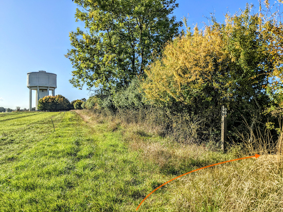 |
| Turn right then head W on Great Munden footpath 45 |
5: Turn right, cross the footbridge, then head W across a field on Great Munden footpath 45, see orange arrow on the image below.
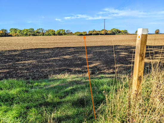 |
| Cross the field following the line of the orange arrow |
Continue across the field for 245m until you reach Stockalls Lane (location -
https://w3w.co/unwound.giggle.rebel).
6: Turn right on Stockalls Lane then head NNW for 120m until you reach a byway on the left (location -
https://w3w.co/stung.riches.safety), see image below.
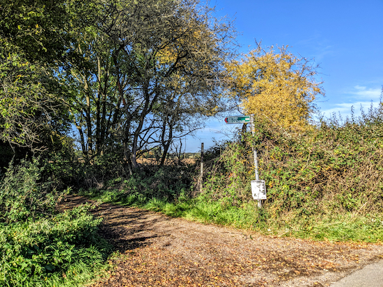 |
| Turn left on Great Munden BOAT 35 |
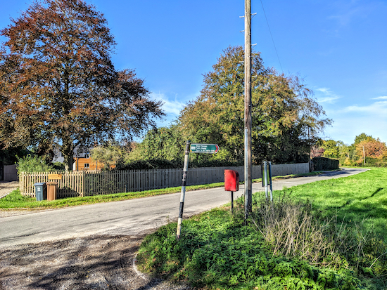
7: Turn left on Great Munden BOAT 35 (
byway open to all traffic) then head SW for 560m until you reach Levens Green (location -
https://w3w.co/excusing.onwards.petty), see image below.
 |
| Turn right on Levens Green then head NW |
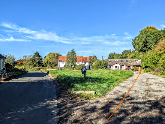
8: Turn right on Levens Green then head NW for 140m until you reach a track on the right (location -
https://w3w.co/celebrate.doghouse.happy), see image below.
 |
| Turn right on a track then head NW |
9: Turn right on a track then head NW for 55m to join a footpath (location -
https://w3w.co/hands.scrubber.coolest), see image below.
 |
| Turn right on Great Munden footpath 34 |
Turn right on Great Munden footpath 34 then head NNW for 390m until you reach a gate (location -
https://w3w.co/joked.edits.kiosk). When we tested this route on Tuesday 11 October 2022 this gate, which is on a public right of way (
ROW) had fallen down and was chained and padlocked to the metal farm gate. We have reported this to Hertfordshire County Council's rights of way (ROW) team
using the online form. We were able to squeeze through a gap between the metal farm gate and the wooden right of way gate, see image below. (
If you walk this route and find this gate has been repaired, please add a comment at the foot of this page and I will edit the directions. Thanks).
 |
| Squeeze through the gap between the gates |
10: Squeeze through the gap between the metal farm gate and the broken right of way gate then continue heading NW, still on Great Munden footpath 34 for 160m with the hedgerow on the right and the field on the left until you reach a footpath on the right (location -
https://w3w.co/offshore.unspoiled.headless), see image below.
 |
| Turn right on Great Munden footpath 29 |
11: Turn right on Great Munden footpath 29 then cut through the hedgerow to reach a field, see image below.
 |
| Head E across the field |
Head E across the next field for 170m until you reach a line of trees (location -
https://w3w.co/walking.scanty.topping), see orange arrow on the image above.
 |
| Continue heading E, still on Great Munden footpath 29 |
Continue heading E, still on Great Munden footpath 29, with a ditch on your right and field on your left, for 340m until you reach a gap in the hedgerow (location -
https://w3w.co/will.physics.winds), see image below.
 |
| Go through the gap, still on Great Munden footpath 29 |
12: Go through the gap, still on Great Munden footpath 29, then head ENE for 190m, with the hedgerow on the right and the field on your left, until you reach Stockalls Lane (location -
https://w3w.co/reckons.item.swaps), see image below.
13: Turn right on Stockalls Lane then head SE for 60m until you reach a footpath on the left (location -
https://w3w.co/herring.vaulting.proven), see image below.
 |
| Turn left on Great Munden footpath 57 |
Turn left on Great Munden footpath 57 then head E for 80m until you reach a field (location -
https://w3w.co/builds.spearing.koala), see image below.
 |
| Head E across the field to the distant hedgerow |
Head E across the field for 510m (see orange arrow on the image above) to a line of hedgerow (location -
https://w3w.co/processor.shoelaces.additives), see image below.
 |
| Head E then ENE, now on Standon footpath 27 |
14: When you reach the hedgerow you will cross a parish boundary. Continue heading E then ENE, now on Standon footpath 27, with the hedgerow on the right and field on the left for 205m until you reach woodland and a junction (location -
https://w3w.co/reverted.alleyway.surcharge), see image below.
 |
| Keep left at the junction then head NE with woodland on the right |
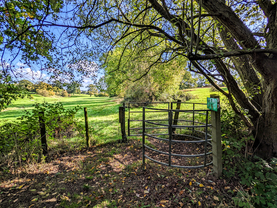
15: Keep left at the junction then head NE then E, still on Standon footpath 27, with the woodland on your right and fields on your left, for 515m until you reach a gate leading to a livestock field (location -
https://w3w.co/conveying.toast.tagging), see image below.
 |
| The gate leading to the livestock fields |
16: You are about to cross the first of several livestock fields. A sign on the post reads:
"Cattle with calves graze these fields at times from April to November. Please try not to get between cows and their calves"
Head E across the first field for 190m to reach a gate (location -
https://w3w.co/talkers.farmer.wheat). At this point curious cattle followed us to the gate, see image below.
 |
| Cattle on Standon footpath 27 |
17: Continue heading E, still on Standon footpath 27, for 390m across another livestock field to another gate (location -
https://w3w.co/held.vivid.yummy).
 |
| Crossing the last livestock field on Standon footpath 27 |
18: After leaving the livestock fields keep heading E for 500m with hedgerow on the right and a field on the left, see image below.
 |
| Continue heading E for 500m with hedgerow on the right |
Continue heading E on Standon footpath 27 until the footpath bends to the right and crosses a footbridge (location -
https://w3w.co/mainframe.frocks.amuses), see image below.
 |
| Cross the footbridge then follow the footpath round to the A10 |
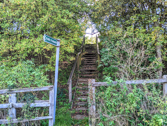
19: Cross the footbridge then follow Standon footpath 27 SE for 110m until you reach steps leading up to the A10 (location -
https://w3w.co/snowmen.examine.helpless), see image below.
 |
| The steps leading to the A10 |
20: When you reach the A10 look to your right for traffic then when you reach the halfway point, look to your left for traffic, see image below.
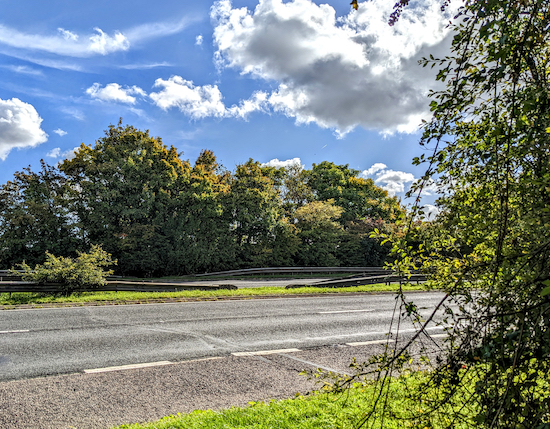 |
| Standon footpath 27 crossing the A10 dual carriageway |
After crossing the A10 continue heading E, still on Standon footpath 27, for 110m until you reach Huntsman Close and the car park on your right where the walk started.
 |
| Huntsman Close car park |
If you want to visit the
White Hart pub/restaurant turn left on High Street then head N for 190m and the pub will be on your right (location -
https://w3w.co/upon.tune.bounding). To visit the
Something Lovely Tea Room or
The Crown & Falcon, turn right on High Street then head S for 75m. For opening times please check the links above for all outlets.
 |
| High Street, Puckeridge |
Interactive map


Hi David walked this route today yep it was wet and heavy but Hey Ho did enjoy it thank you . Your remark about point 10 well it looks the same. I’m a big bloke and used the same gap, can’t see council sorting any time soon ( have sent you an email with pics ). I have sent pics to ROW re large fallen tree foot path 27 close to A10 👍 . IR.
ReplyDeleteThanks Ian, just seen your email and the pics. Thanks for reporting to HCC ROW. They need to sort that gate out.
DeleteHi there - thanks for the fantastic work on this site. I walked this route today and the gate at direction 10 is fixed. I took a photo which I’d be happy to send on.
ReplyDeleteHi,
DeleteThanks for letting me know. It just shows the value of reporting such issues to HCC's rights of way team. If you could send a photo that would be great. I will then update the walk directions.
Could you please use the site's contact form so we can connect - link below...
https://www.hertfordshirewalker.uk/p/contact-us.html
By the way, if you haven't done so already you might want to join our new Facebook group where members can post photos and updates about the walks they are doing. The more the merrier. :-)
https://www.facebook.com/groups/hertfordshirewalker
I filled in the contact form but not sure if it sent - didn’t get a confirmation - let me know if you didn’t receive and I’ll do so again.
DeleteHi, thanks for the message. I have been through the contact form emails and it's hard to know which one is from you because there is no name or topic mentioned in your message above. I know I am up-to-date with replies to all messages, so perhaps you didn't send it? Would you mind trying again, please? Thanks
ReplyDeleteThanks so much for this wonderful site - we did this walk a few weeks ago, instructions were perfect and was a lovely enjoyable (if muddy) walk!
ReplyDeleteSo glad you enjoyed it, despite the mud. If you haven't already done so please consider joining our friendly Facebook group where fellow walkers are sharing photos and tips from their walks.
Deletehttps://www.facebook.com/groups/hertfordshirewalker
FYI the Something Lovely Tea Room closed a while ago. It’s now Puckeridge Local Store
ReplyDeleteThanks for the update
Delete