3.7 miles (6 km) with 27m of total ascent
 |
| The path through Bencroft Wood at the start of the walk |
This is a lovely walk following trails through deep woodland, passing through nature reserves and crossing arable farmland. There are a few sections in the woods where leaves and fallen trees can obscure the route. If you have a smartphone with GPS you will find the free navigation files helpful in such cases. I have added photographs to my description of the route to try to clarify certain turning points in the woodland.
The route crosses one livestock field where horses were grazing when we tested the walk. You will walk past
The Woodman & Olive pub/restaurant at Wormley West End. There is also a short section where a public footpath is in the process of being rerouted. I have provided maps to show the current status of the right of way. The starting point for the walk is three miles W from Broxbourne Station by road.
Fly over the route before you set off
If you want to check what sort of landscape this walk covers before setting off you can view a short 3D video of the route below. It's created using the free version of
Relive.
Directions
 |
Map for Walk 211: Wormley West Loop
Click here or on the map for a larger version
Created on Map Hub by Hertfordshire Walker
Elements © Thunderforest © OpenStreetMap contributors
There is an interactive map below the directions |
Those with GPS devices can download
GPX or
KML files for this walk. We've added
What3Words location references for those who use that system. If you print these walks you might want to use the green
PrintFriendly icon at the bottom of these directions to delete elements such as photographs.
There are two parking choices for this walk, the Bencroft Wood west car park (location -
https://w3w.co/exchanges.bossy.spray) or the Bencroft Wood east car park (location -
https://w3w.co/casual.lines.discrepancy), off White Stubbs Lane.
Both car parks offer easy access to the route although at different points along the way. Our directions below start from the Bencroft Wood east car park. If you use the Bencroft Wood west car park you will join the walk near point 20 then head E.
Bencroft Wood, along with Broxbourne Wood, are managed by
The Woodland Trust.
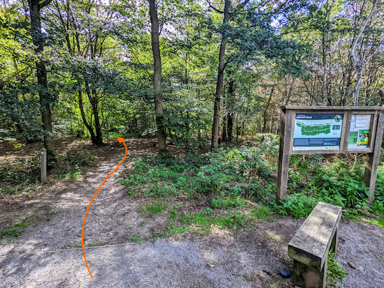 |
| The path S from Bencroft Wood east car park |
1: From the Bencroft Wood east car park take the path to the left of the information board (see image above) then head SE for 135m until you reach a junction (location -
https://w3w.co/coach.reward.plug), see image below.
 |
| The path from the car park meeting Broxbourne Wood NNR trail |
2: Turn left on the Broxbourne Wood NNR (
National Nature Reserve) Trail then head E for 210m until you reach West End Road (location -
https://w3w.co/gentle.ants.rather), see image below.
 |
| Cross West End Road then enter Emanuel Pollards |
3: Cross West End Road then enter Emanuel Pollards and head NE for 140m until you reach a junction (location -
https://w3w.co/closet.stroke.with), see image below.
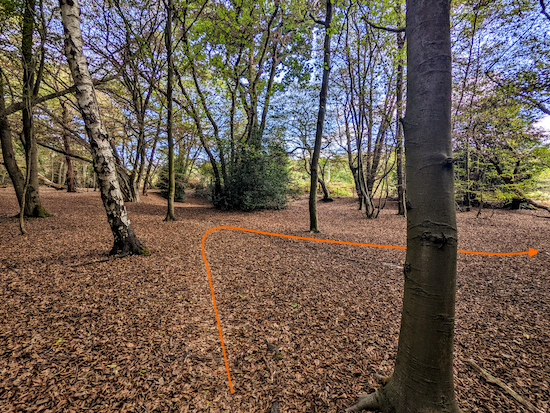 |
| Turn right at the junction on Brickendon Liberty footpath 21 |
4: This bit is tricky to describe because there are no signposts and the path is covered in leaves and fallen branches, but here goes. (If you have a smartphone I suggest you download our free
GPX file for this walk).
At the junction (see image above) turn sharp right then head S on
Brickendon Liberty footpath 21 for 10m then follow the footpath to the left of a dip, see image below.
 |
Follow Brickendon Liberty footpath 21 to the left of the dip
|
Continue winding through the woods in a southerly direction on Brickendon Liberty footpath 21. You will be walking close to the eastern edge of the woodland and should see fields through the trees on your left.
Keep heading S then SSW for 135m until you reach a wooden sign on the right which reads 'The Woodman Public House'. There will be a gate opposite the sign (location -
https://w3w.co/oldest.animal.plots), see image below.
 |
| Turn left then go through the gate and head SSE |
5: Go through the gate then head SSE, still on Brickendon Liberty footpath 21, for 375m until you reach West End Road (location -
https://w3w.co/pots.spicy.hint). The Woodman & Olive pub/restaurant will be opposite when the footpath reaches the road, see image below.
 |
| The Woodman & Olive on West End Road |
6: Turn right on West End Road then head W for 60m, passing The Woodman & Olive pub/restaurant on the left (location -
https://w3w.co/keys.form.harder) then take the footpath on the left immediately after the pub (location -
https://w3w.co/diner.showed.fans), see image below.
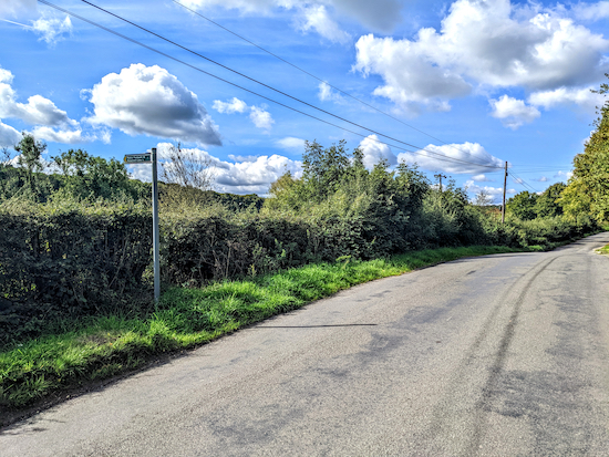 |
| Turn left on Brickendon Liberty footpath 19 |
Turn left on Brickendon Liberty footpath 19 then head SSE through the pub car park to a gate leading to the beer garden. Continue through the beer garden on this
public right of way for 80m until you reach a gate leading to a footbridge over
Wormleybury Brook. The brook is a tributary of the
River Lea (location -
https://w3w.co/ready.leap.blitz), see image below.
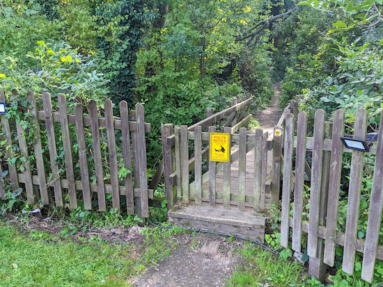 |
| The footbridge over Wormleybury Brook |
Cross the footbridge then head SSE through woodland, still on Brickendon Liberty footpath 19, for 75m until the path splits (location -
https://w3w.co/blank.wanted.tubes), see image below.
 |
| Take the right fork still on Brickendon Liberty footpath 19 |
Keep to the right when the path splits and continue heading SSE still on Brickendon Liberty footpath 19 for 100m until you reach a junction (location -
https://w3w.co/error.highs.scope), see image below.
 |
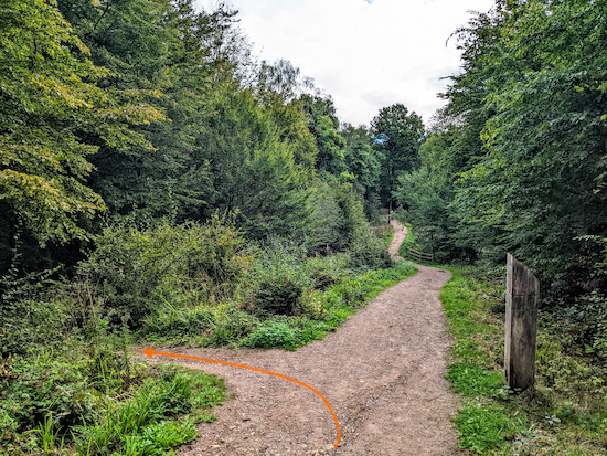
| Turn left on Cheshunt footpath 29 |
7: Again the signage here isn't clear. There is one waymark post, see image above, and some fallen branches. Follow the direction of the orange arrow in the image above by turning left on
Cheshunt footpath 29 then heading ESE for 85m passing a metal fence on the left (location -
https://w3w.co/miss.both.secure), see image below.
 |
| Head ESE past the metal fence |
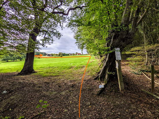
Head ESE past the metal fence until you reach a footpath on the right at the SW edge of the woodland. (location -
https://w3w.co/caves.falls.best), see image below.
 |
| Turn right on Cheshunt footpath 29 |
8: Turn right at the junction, still on Cheshunt footpath 29, then head S with the trees on your right and the field on your left. At this point Cheshunt footpath 29 has been rerouted. Please see the new route set out on the Hertfordshire County Council map below. The old route is the purple solid line, the new route is the black dotted line between points G and A.
 |
| Hertfordshire diversion order for Cheshunt footpath 29 |
Continue heading S on Cheshunt footpath 29 for 140m towards a solitary gate (location -
https://w3w.co/print.hits.order), see image below.
 |
| Turn left at the gate then head E |
9: Turn left at the gate then head E for 95m to another gate (location -
https://w3w.co/crop.branch.yards). Go through the gate then continue straight, following the rerouted Cheshunt footpath 29 as it heads E for 65m then bends to the right and heads SE for 75m until it reaches the hedgerow where you turn right and head S, with the hedgerow on your left and the field on your right, for 65m to reach a gate (location -
https://w3w.co/souk.deed.legend), see image below.
 |
| Follow Cheshunt footpath 29 S to Beaumont Road |
Go through the gate then keep heading S for 60m with the hedgerow on the left and field on the right until you reach a gate leading to Beaumont Road (location -
https://w3w.co/pets.offer.afford).
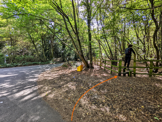
10: Turn left on Beaumont Road then head E for 35m to a road junction where you will see a stile on your right leading into the woodland (location -
https://w3w.co/duke.stud.pretty), see image below.
 |
| Cross the stile on the right just before the road junction |
Cross the stile on the right just before the road junction then enter
Thunderfield Grove which is a
Woodland Trust nature reserve.
Keep right and head SW through Thunderfield Grove for 45m until the path bends to the right (location -
https://w3w.co/coins.useful.visits), see image below.
 |
| Keep right then head W for 175m |
11: Keep right then head W for 175m until you reach a junction (location -
https://w3w.co/dwell.gears.hoot), see image below.
 |
| Follow the path as it bends left at the junction |
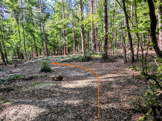
12: Follow the path as it bends left at the junction then heads SW for 60m to another junction (location -
https://w3w.co/oven.blitz.lines), see image below.
 |
| Turn right at the junction then head W |
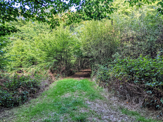
13: Turn right then head W for 380m to a junction just before a pylon (location -
https://w3w.co/fire.flood.track), see image below.
 |
| Turn right on Cheshunt footpath 32 |
14: Turn right on Cheshunt footpath 32 then head NNW for 200m until you reach Beaumont Road (location -
https://w3w.co/plays.stress.super).
15: Turn left on Beaumont Road then head W for 500m until the road becomes a track. This is Cheshunt UCR 1 (
unmetalled, unclassed, county road) (location -
https://w3w.co/finishing.boom.feeds).
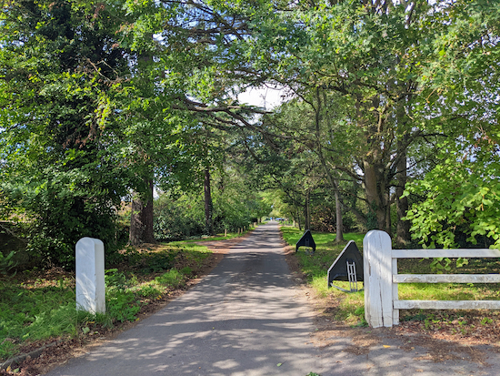 |
| Beaumont Road 250m before it becomes Cheshunt UCR 1 |
16: Continue heading W, now on Cheshunt UCR 1, for 770m until you reach a junction (location -
https://w3w.co/fits.until.bucked), see image below.
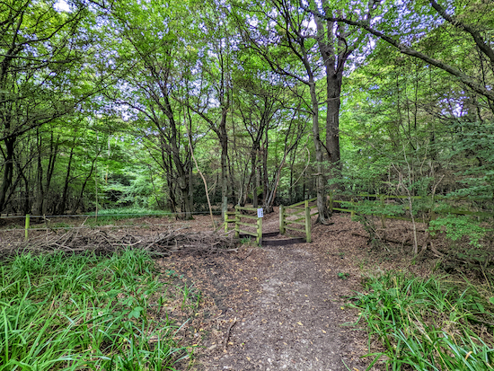 |
| Turn right on Cheshunt footpath 76 |
17: Turn right on Cheshunt footpath 76 then head N 340m until you reach a coal post on the left, (location -
https://w3w.co/shack.listed.humans), see image below.
 |
| The coal post alongside Cheshunt footpath 76 |
The coal post is one of 250 erected following the introduction of the
Coal Duties Act of 1851. I wrote
a feature on Hertfordshire's coal posts if anyone is interested in the topic.
18: After the coal post the footpath crosses the parish boundary and becomes Brickendon Liberty footpath 29 (location -
https://w3w.co/rides.names.farms).
 |
| Brickendon Liberty footpath 29 heading E |
Follow Brickendon Liberty footpath 29 E for 300m until the footpath bends left (location -
https://w3w.co/league.fails.nurse) then heads N for 360m to a footbridge (location -
https://w3w.co/slap.pouch.tribes), see image below.
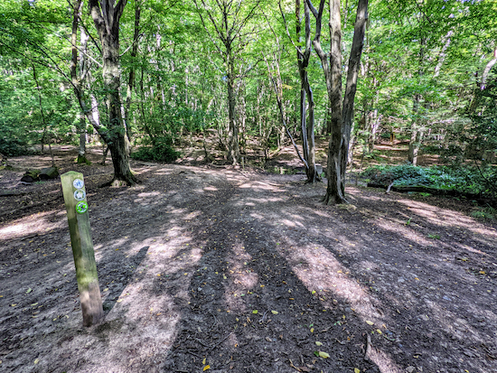 |
| Brickendon Liberty footpath 29 approaching the footbridge |
19: Cross the footbridge then continue heading N still on Brickendon Liberty footpath 29 for 200m until you reach a junction (location -
https://w3w.co/mirror.stops.intent), see image below.
 |
| Turn right at the junction then follow a permissive path |
20: Turn right at the junction then follow a permissive path E for 490m until you reach the junction with Brickendon Liberty footpath 17 (location -
https://w3w.co/drive.rods.purple), see image below.
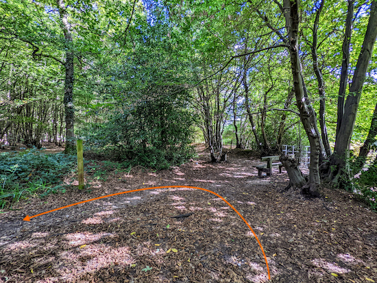 |
| Turn left on Brickendon Liberty footpath 17 |
21: Turn left on Brickendon Liberty footpath 17 then head NW for 110m until you reach a junction with the Broxbourne Wood NNR Trail (location -
https://w3w.co/weeks.wipes.deed), see image below.
 |
| Turn right on Broxbourne Wood NNR Trail then head E |
22: Turn right on Broxbourne Wood NNR Trail then head E for 75m until you reach a path on the left (location -
https://w3w.co/wallet.audit.sooner), see image below.
 |
| Turn left then follow the track back to the car park |
23: Turn left then follow this track NE for 130m back to the car park.
Interactive map
We have three more walks in this area. They are:


We enjoyed this lovely walk today, it is now fully signposted so very easy to follow.
ReplyDeleteBrilliant, so glad you enjoyed it Anne, thanks for the feedback.
DeleteReally enjoyed this walk today. Ideal length for two children (10 & 7). Good directions. Thank you.
ReplyDeleteWonderful. So glad you enjoyed it. Thanks for the feedback. :-)
DeleteWe really enjoyed this walk..The part where it's re-routed where the solitary gate is now has a new fence running either side of the gate. Still well signposted. 10/10 for this walk.
ReplyDeleteExcellent, so glad you enjoyed it. And thanks for sharing the update. David
DeleteThis site is protected by reCAPTCHA and the Google privacy policy and Terms of Service apply.
ReplyDeleteHi Olsen, are you saying you are unable to access Hertfordshire Walker?
Delete