4.7 miles (7.6 km) with 89m of total ascent
 |
| The footpath between points 21 & 22 |
This walk starts and finishes at a small car park close to
Gustard Wood Common then heads S to
Wheathampstead where we detour along the restored platform of the former
Wheathampstead station before heading E along the
River Lea then N through woodland and across open fields. The route passes
The Cross Keys pub at Gustard Wood near the end.
In the 17th century those walking the paths you will explore would have been on the lookout for the notorious highwaywoman '
The Wicked Lady', who was said to have
"terrorised" people living in the local area.
There are 40 images in the following directions. If you like to print our directions to take with you on the walk you can delete any unwanted elements (such as photographs) by using the free PrintFriendly tool.
Click here to find out how.
Regular users of this site will notice that some of the footpaths, bridleways and byways on this walk feature in other walks. We have combined them with public rights of way that we have not walked previously to create a new loop.
Check the route before you set off
If you want to check what sort of landscape this walk covers before setting off you can view a short 3D video of the route below. It's created using the free version of
Relive.
Directions
 |
Map for Walk 209: Gustard Wood South Loop
Click on the map for a larger version
Created on Map Hub by Hertfordshire Walker
Elements © Thunderforest © OpenStreetMap contributors
There is an interactive map below the directions |
Those with GPS devices can download
GPX or
KML files for this walk. We've added
What3Words location references for those who use that system. If you print these walks you might want to use the green
PrintFriendly icon at the bottom of these directions to delete elements such as photographs.
1: From the small car park off Lamer Lane (location -
https://w3w.co/crown.oddly.change) head SE into the woodland, see image below.
 |
| Head SE from the southern end of the car park |
Continue heading SE for 95m until you reach a junction (location -
https://w3w.co/print.crib.given) where you turn right on Wheathampstead
bridleway 101.
 |
| Wheathampstead bridleway 101 |
Turn right on Wheathampstead bridleway 101 then head S for 260m until you reach Lamer Lane (location -
https://w3w.co/obey.dine.ships). Cross Lamer Lane then turn left and head SSE on the W side of the road for 90m until you reach a lane on the right (location -
https://w3w.co/thing.decks.proper) which is also Wheathampstead bridleway 2, see image below.
 |
| Turn right off Lamer Lane on Wheathampstead bridleway 102 |
2: Turn right off Lamer Lane on Wheathampstead bridleway 102 then head W across Gustard Wood Common and through the grounds of the
Mid Herts Golf Club.
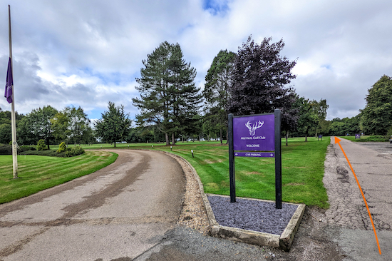 |
| Wheathampstead bridleway 102 heading W across the golf course |
The public right of way, Wheathampstead bridleway 102, crosses several fairways. Please look to your right and left to check whether any golfers are hitting golf balls in your direction. There are signs asking dog owners to keep their pets on a lead.
After 560m you will reach a junction outside a farm (location -
https://w3w.co/bunk.menu.wiser), see image below.
 |
| Turn left on Wheathampstead bridleway 58 |
3: Turn left on Wheathampstead bridleway 58 then head S for 115m until the bridleway turns right at the end of a barn then heads W for 40m to a junction (location -
https://w3w.co/fluid.combining.spared), see image below.
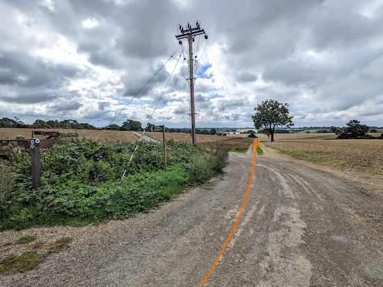 |
| Head S at the junction, still on Wheathampstead bridleway 58 |
4: Head S at the junction, still on Wheathampstead bridleway 58, for 260m until you reach a
footpath on the left immediately before some bushes (location -
https://w3w.co/talked.battle.bravo), see image below.
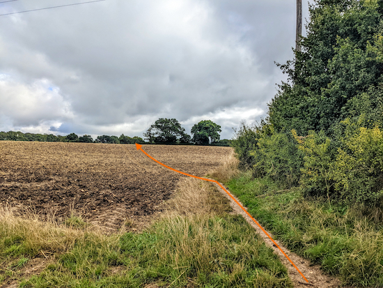 |
| Turn left on Wheathampstead footpath 90 then head NE |
5: Turn left on Wheathampstead footpath 90 then head NE for 170m to a farm track (location -
https://w3w.co/nature.artist.places). When we tested this walk on 10 September 2022 the field had recently been ploughed. I have added an orange arrow to the image above to show the right of way.
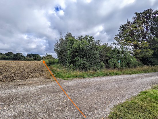 |
| Cross the farm track heading NE on Wheathampstead footpath 90 |
6: Cross the farm track then continue heading NE, still on Wheathampstead footpath 90, with the hedgerow on the right and the field on the left, for 155m until you reach the Mid Herts Golf Club again (location -
https://w3w.co/firmly.dime.tribes). Continue for 30m until you reach a footpath on the right (location -
https://w3w.co/talked.cube.alert), see image below.
 |
| Turn right on Wheathampstead footpath 57 |
7: Turn right on Wheathampstead footpath 57 then follow it SSE for 470m, with the hedgerow on the left and the golf course and fields on the right, until you reach a gate where the footpath leaves the golf course (location -
https://w3w.co/window.fears.heave), see image below.
 |
| Continue heading SSE on Wheathampstead footpath 57 |
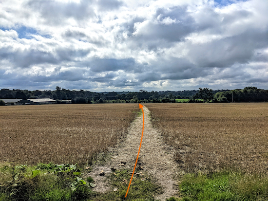
8: Go through the gate then cross a farm track before continuing to head SSE across a field still on Wheathampstead footpath 57, see image below.
 |
| Cross the field on Wheathampstead footpath 57 |
Continue across the field for 220m until you reach the hedgerow and a metal gate (location -
https://w3w.co/comic.calms.active). I have added an orange arrow to the image above in case the field is ploughed and the right of way is hard to see.
Go through the gate then continue, still heading SSE and still on Wheathampstead footpath 57, for 320m keeping to the right of a large tree (location -
https://w3w.co/dart.daring.discouraged) and continuing until you reach Lamer Lane (location -
https://w3w.co/dragon.wings.oven), see image below.
 |
| Turn right on Lamer Lane then head S along the pedestrian pavement |
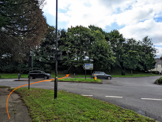
9: Turn right on Lamer Lane then head SW and S along the pedestrian pavement for 200m to the roundabout where the B651 meets the B653 (location -
https://w3w.co/water.handy.bond), see image below.
 |
| Cross the B653 to reach the steps to the former station |
10: Cross Lamer Lane from the W (right) side to the E (left) side (location -
https://w3w.co/faster.wipes.prep) then head E (left) at the roundabout on the B653 for 10m until you reach a crossing on the right (location -
https://w3w.co/horns.worry.punks), see orange arrow on the image above.
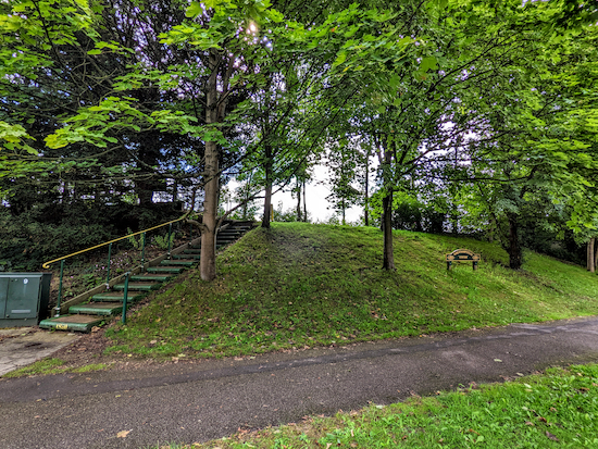
Cross the B653 to reach the steps (location -
https://w3w.co/tummy.melt.scope) on the S side of the road which lead to the former Wheathampstead Station (location -
https://w3w.co/both.invite.churn), see image below.
 |
| The steps to the former Wheathampstead Station |
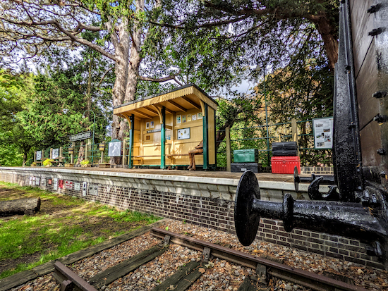
The following pictures are of the former station.
You can delete any unwanted images using the free PrintFriendly tool.
 |
| Carving of George Bernard Shaw at the station |
 |
| The Wheathampstead Heritage Trail sign |
 |
| Former Wheathampstead Station platform and rolling stock |
 |
| Former Wheathampstead Station platform |
 |
| Rolling stock at the former Wheathampstead Station |
Click on any of the following information board images to see the photographs in full size.
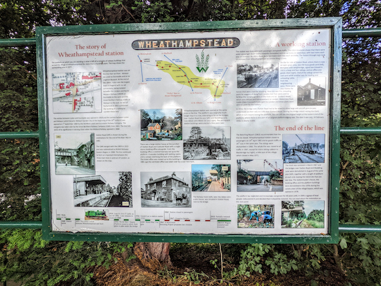 |
| The story of Wheathampstead Station |
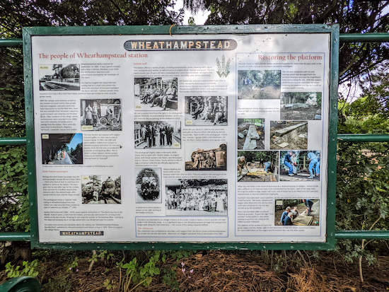 |
| The people of Wheathampstead Station |
 |
| The laying of the track |
 |
| The story of the waggon |
11: Exit Wheathampstead Station via the stairs at the eastern end of the platform then turn right on Wheathampstead bridleway 17 (location -
https://w3w.co/analogy.field.trace), see image below.
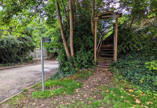 |
| Wheathampstead Station exit and Wheathampstead bridleway 17 |
12: Follow Wheathampstead bridleway 17 head S for 120m until you reach a footpath junction (location -
https://w3w.co/gift.light.being), see image below.
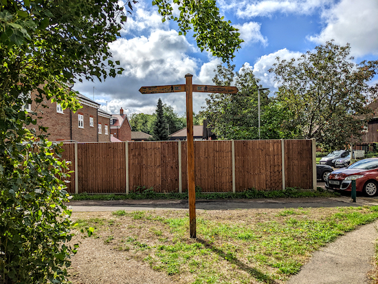 |
| Turn left on Wheathampstead bridleway 12 |
* If you need refreshments you could take a detour at this point by turning right on Wheathampstead bridleway 12 then follow it W for 100m to Station Road then turn left and head into the village where you will find cafes and pubs, including Loafing Bakery, The Bull, The Reading Rooms, The Swan, and Brewhouse Coffee.
If you don't take the detour turn left at the junction then head W on Wheathampstead bridleway 12 for 120m to the point where the path forks (location -
https://w3w.co/grit.fishery.deck), see image below.
 |
| Turn right at the fork on a permissive path |
13: Turn right at the fork on a permissive path which heads SE for 80m to a bridge over the River Lea (location -
https://w3w.co/gifted.vest.grow), see image below.
 |
| Don't cross the bridge but instead keep left and head NE |
14: Don't cross the bridge but instead keep left and head NE along the permissive path with the River Lea on the right for 210m until you rejoin Wheathampstead bridleway 12 (location -
https://w3w.co/rainy.regime.claims), see image below.
 |
| Turn right on Wheathampstead bridleway 12 |
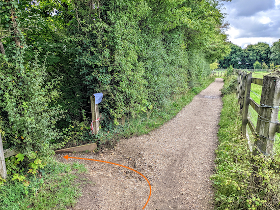
15: Turn right on Wheathampstead bridleway 12 then head SE for 330m then SSE for 90m to a staircase on the left accessible via a gap in the hedgerow (location -
https://w3w.co/steep.bells.store), see image below.
 |
| Go down the steps to reach Wheathampstead BOAT 4 |
16: Go down the steps to reach Wheathampstead BOAT 4 (
byway open to all traffic) (location -
https://w3w.co/patch.woke.help). Turn left on Wheathampstead BOAT 4 then go through an underpass and head NNE for 195m until you reach a footpath on the left (location -
https://w3w.co/struck.crate.evenly), see image below.
 |
| Turn left on Wheathampstead footpath 63 |
17: Turn left on Wheathampstead footpath 63 then head NW for 90m until the path drops down to cross
Ayot Greenway (location -
https://w3w.co/news.minus.tilt), see image below. The Ayot Greenway is the former branch line between Welwyn Garden City and Luton which passed through Wheathampstead Station.
 |
| Cross Ayot Greenway to continue on Wheathampstead footpath 63 |
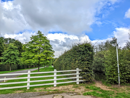
18: Cross Ayot Greenway then climb the bank to continue on Wheathampstead footpath 63 heading NNW for 400m to Codicote Road (location -
https://w3w.co/goat.shaped.lawn).
 |
| Cross Codicote Road then take Wheathampstead footpath 39 |
19: Cross Codicote Road then take Wheathampstead footpath 39 N for 460m to a junction (location -
https://w3w.co/assure.woods.cafe), see image below.
 |
| Turn left at the junction on Wheathampstead footpath 38 |
20: Turn left at the junction on Wheathampstead footpath 38 then head NW for 300m to a junction (location -
https://w3w.co/about.bigger.radar), see image below.
 |
| Turn right at the junction then left on Wheathampstead footpath 38 |
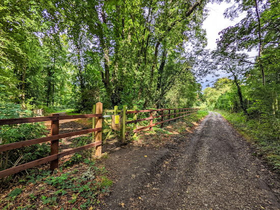
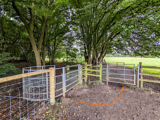
21: Wheathampstead footpath 38 now crosses Wheathampstead footpath 41 by turning right then heading N for 20m before turning left at a gate then entering woodland (location -
https://w3w.co/turns.dust.estate), see image below.
 |
| Turn left on a continuation of Wheathampstead footpath 38 |
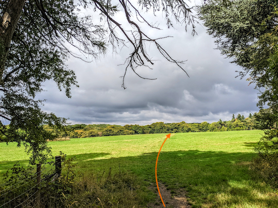
Follow Wheathampstead footpath 38 NW for 170m until you reach an open field (location -
https://w3w.co/life.grapes.gain), see image below.
 |
| Head NW across the field for 350m until you reach a lane |
22: Head NW across the field for 350m until you reach a lane (location -
https://w3w.co/launch.either.dent), see image below.
 |
| Follow Wheathampstead footpath 85 N for 820m |
23: Cross the lane then follow Wheathampstead footpath 85 N for 820m until you leave the woodland at a gate and reach a footpath junction (location -
https://w3w.co/that.basin.bond), see image below. This stretch of woodland is carpeted in bluebells in the spring.
 |
| After leaving the woodland at a gate turn left to another gate |
24: After leaving the woodland at the gate turn left then go though a second gate now on Wheathampstead footpath 36, which is also Kimpton footpath 12 at this point. Head SW then WSW for 350m first across a field and then alongside a wall until you reach Ballslough Hill (location -
https://w3w.co/save.half.quick).
25: Turn left on Ballslough Hill then pass The Cross Keys on your right (location -
https://w3w.co/adults.preoccupied.tilt), see image below.
 |
| The Cross Keys |
Continue heading SWE on Ballslough Hill for 60m looking out for a bridleway on the left (location -
https://w3w.co/select.always.prove), see image below.
 |
| Turn left on Wheathampstead bridleway 101 |
26: Turn left on Wheathampstead bridleway 101 then head SSE for 170m until you reach a track (location -
https://w3w.co/served.transmitted.study). Soon after crossing the track you will come to a path on the right (location -
https://w3w.co/vocal.laser.photos), see image below.
 |
| Turn right on the path and follow it back to the car park |
27: Turn right on the path and follow it S for 170m back to the car park (location -
https://w3w.co/folds.record.spout).
Walkers have recommended three cafes in Wheathampstead,
Loafing (location -
https://w3w.co/ready.sweat.wooden),
Marley's (location -
https://w3w.co/driven.sheet.cheeks), and
Brewhouse Coffee (location -
https://w3w.co/unions.trace.fats)
If you enjoyed this walk please consider joining our
Hertfordshire Walker members-only Facebook Group where you can share photos and comments on your walking experiences.
Interactive map


Hi Dave, Is there a problem with this GPX file as I can't upload it?
ReplyDeleteHi Beryl, thanks for the feedback. Sorry to hear you are having problems. Are you using the OS app? I have tested the GPX file several times, when mapping and publishing the walk and just now on my desktop and phone. The file works fine for me on the OS online site, on Komoot, on Routes, GPX Viewer and Relive. However I see it won't load in the OS app on my phone, although it works fine in the free Komoot app. This happens from time to time with the OS app. I have written to the OS and explained the issue, and they have admitted it's a known problem and are looking into it. I will raise it again with them. In the meantime, please download the free Komoot and use that if I walk won't download in your OS app. I will post a note on the site when the OS rectifies the issue. I wrote a note about the problem in this site's 'Tips' page.
Deletehttps://www.hertfordshirewalker.uk/p/tips.html#OSA
Dave
One more suggestion for you, Beryl. Save the GPX file for the walk on your desktop. Open the OS page on your desktop device. You will see it opens fine. Save the walk on the desktop device. Go to your mobile device. Find the walk. Open it there. You will find it works.
DeleteDave
Hi Dave, I use the free outdooractive app. Having tried it again this morning I have successfully downloaded it. I think it must have been my laptop playing up yesterday. Sorry to have bothered you and thank you for being so helpful.
ReplyDeleteHi Beryl, no problem. It is good you raised it and has encouraged me to check it out again. Enjoy the walk. Dave
DeleteHi Dave Love Gustard Wood one of my favourites . Today lay-by starting point very busy. So I parked in the public car park behind ‘The Bull’ in Wheathampstead and joined the walk at point 14, worked well as did all the up gradient walking at beginning of walk Thank you again. .IR.
ReplyDeleteGood idea joining the walk at point 14. Thanks for sharing that tip. Dave
DeleteDid this walk , this morning David . Blessed by the sunshine . Really enjoyed it with a lovely mixture of open fields and then some woodland walking , not forgetting dodging the golf balls at Mid Herts . Bit muddy through the woods before the field at point 22 otherwise really good underfoot . Cheers Mick
ReplyDeleteGlad you enjoyed it Mick, thanks for the feedback. It was a good morning for walking. We were also out revisiting an old favourite close to where you were. It just started to get muddy where the sun was shining on the ground towards the end.
DeleteWhat a lovely varied walk which we did this morning. Parts of Gustard Wood were carpeted with snowdrops. Thank you again for providing these walks.
ReplyDeleteWonderful, thanks Beryl. Glad you enjoyed it. A lovely walk. Dave
DeleteHello
ReplyDeleteAnother great walk, very clearly described, except, I think it’s head NW at point 20 rather than NE. It’s kinda a Y junction there so heading NE would take you right and the wrong way along that path.
Great spot, thanks so much. You are right, it's NW not NE. I have edited it. I hope you didn't get lost. And thanks so much for taking the time to point it out. Really appreciated. David
DeleteSuper walk which we did today. Started at East Lane car park (free) & enjoyed halfway lunch at Cross Keys Pub.
ReplyDeleteSo glad you enjoyed the walk and that lunch at the Cross Keys was good. Thanks for the feedback. David
DeleteAnother lovely walk - a really good variety of fields and woods and the interest of the beautifully restored Wheathampstead station. We really appreciate all the wonderful walks you have uploaded.
ReplyDeleteThanks for the feedback Susie. So glad you enjoyed the walk.
Delete