4.4 miles (7 km) with 71m of total ascent
 |
| Holy Trinity church Throcking towards the end of the walk |
We really enjoyed this walk over the rolling countryside north-east of Cottered. It starts and finishes at
The Bull on Baldock Road, Cottered, and passes the hamlet of Throcking where it's worth taking time to wander round the churchyard of Holy Trinity church, which has sections dating back to the 13th century.
The route crosses many arable fields which, after the crops have been harvested and the fields ploughed, can be difficult to walk. When we did this walk on 9 September 2022 our boots became clogged with mud.
If you don't want to battle with the mud it might be worth bookmarking this walk and doing it in dry weather when the paths have been reinstated after ploughing.
And because several fields have recently been ploughed it's difficult to work out the direction of the paths, so I have added orange arrows to many of the images below to show the direction of the right of way.
We crossed one livestock field and spotted a couple of signs asking walkers to keep their dogs on a lead.
Getting there
There are bus stops close to the start of the walk which are served by the number 37 bus. You can check bus times at
Intalink.
Fly through preview
If you want to check the walk before you go try the flythrough below, created on
the free Relive app.
 |
| Boots weighed down with mud |
If you have a smartphone consider downloading our free GPS navigation files (links to the files below the map) which enable you to follow the correct route on a free app such as
Komoot.
Directions
 |
Map for Walk 208: Cottered North-East Loop
Click here or on the map for a larger version
Created on Map Hub by Hertfordshire Walker
Elements © Thunderforest © OpenStreetMap contributors
There is an interactive map below the directions |
Those with GPS devices can download
GPX or
KML files for this walk. We've added
What3Words location references for those who use that system. If you print these walks you might want to use the green
PrintFriendly icon at the bottom of these directions to delete elements such as photographs.
 |
| The Bull, Cottered at the start of the walk |
1: As you face
The Bull in
Cottered (location -
https://w3w.co/fellow.milky.named) head NE on Bull Lane (to the right of the pub as you look at it) for 60m until the lane becomes a track (location -
https://w3w.co/vaccines.dried.oaks). Continue, now on Cottered
restricted byway 1, for 370m until you a gap in the hedgerow leading to a field (location -
https://w3w.co/bombard.ballpoint.custom), see image below.
 |
| Cottered restricted byway 1 at point 2 |
2: Cottered restricted byway 1 now crosses an arable field. Because the right of way is not clear I have added an orange arrow on the image below to show the direction.
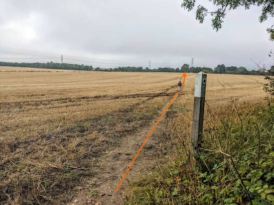 |
| Cottered restricted byway 1 heading NE across a field |
Cottered restricted byway 1 continues heading NE for 500m before reaching a junction (location -
https://w3w.co/producing.scariest.migrants), see image below.
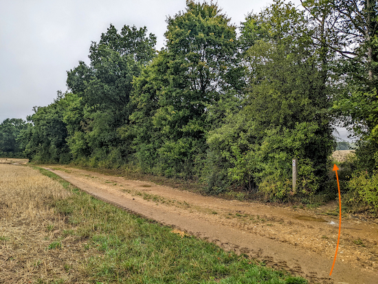 |
| Go through the gap in the hedge still on Cottered restricted byway 1 |
3: Take the path through the gap in the hedge and cross a footbridge, still Cottered restricted byway 1. Once through the gap turn left then head N with the hedgerow on the left and field on the right for 160m until the byway bends to the right (location -
https://w3w.co/skimmers.guessing.decorate), see image below.
 |
| Head N with the hedgerow on the left and field on the right |
4: Follow Cottered restricted byway 1 round the field to the right then head NE for 210m to a junction (location -
https://w3w.co/snares.scatter.requiring), see image below.
 |
| Turn left at the junction then cross a footbridge |
5: Cross a footbridge then continue heading NE, now on Cottered
bridleway 1, for 310m until you cross a farm lane (location -
https://w3w.co/island.responses.blesses), see image below.
 |
| Cross the farm lane then head NE, still on Cottered bridleway 1 |
6: Cross the farm lane then continue heading NE, still on Cottered bridleway 1, crossing a livestock field for 110m until you reach a gate (location -
https://w3w.co/bloomers.cost.violinist), see image below.
 |
| Go through the gate then head NE across a field |
Go through the gate then head NE across the next field for 130m heading to the right of a patch of woodland in the middle of the field (location -
https://w3w.co/socket.tangent.already), see image above.
* When we tested this walk on 9 September 2022 the field had recently been ploughed. The right of way wasn't clear and our boots became heavy with mud. See direction of orange arrow on image above showing the right of way.
When you reach the patch of woodland in the middle of the field continue heading NE for 310m, still on Cottered bridleway 1, until you reach the edge of Great Wood (location -
https://w3w.co/swooned.bill.doormat), see image below.
 |
| Cottered bridleway 1 approaching the edge of Great Wood |
7: When you reach the edge of the woodland turn right on
Sandon footpath 42 then head ENE for 440m across the next field, see image below.
 |
| Sandon footpath 42 heading ENE |
The second section of this field after the brow of the hill (location -
https://w3w.co/chase.movie.improvise) was particularly difficult having been recently ploughed, see image below.
 |
| Head to the right of the woodland on Sandon footpath 42 |
When you reach Park Wood you come to a junction (location -
https://w3w.co/covertly.evoke.kingpin) , see image below.
 |
| Head NE at the junction on Sandon footpath 28 |
8: Head NE at the junction on Sandon footpath 28 with the woodland on the left and field on the right for 110m until the footpath turns right and crosses a field (location -
https://w3w.co/sonic.paces.vest), see image below.
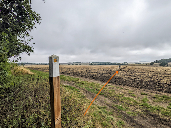 |
| Keep heading ENE, still on Sandon footpath 28 |
9: Head ENE on Sandon footpath 28 for 240m to a junction in the middle of the field (location -
https://w3w.co/articulated.sushi.attention). Unfortunately this junction had also been ploughed and there wasn't a marker post, so Ellie had to model as one, see image below.
 |
| Ellie acting as a marker post for the junction mentioned below |
10: Turn right at the junction on Sandon footpath 30 then head S for 90m to a footbridge (location -
https://w3w.co/museum.players.flop), see image below.
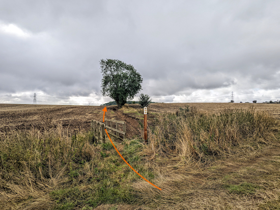 |
| Cross the footbridge then keep heading S on Sandon footpath 30 |
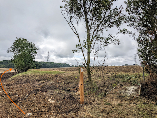
Cross the footbridge then head SSE with a ditch on your right and a field on your left for 160m until you reach a footbridge on the right (location -
https://w3w.co/regret.bridge.knees), see image below.
 |
| Sandon footpath 30 does not cross the footbridge |
11: Do not cross the bridge. Instead keep heading SSE, still on Sandon footpath 30, with the ditch on the right, see orange arrow on the image above.
* When we tested this walk in September 2022 irrigation work on the ditch had recently been completed and the path was unclear and hard to walk. However, if you keep the ditch on the right you will eventually reach a solid track.
Continue heading SSE, still on Sandon footpath 30, for 200m until you reach a footpath on the left (location -
https://w3w.co/bland.shifters.lessening), see image below.
 |
| Keep heading SSE, still on Sandon footpath 30 |
Ignore this path on the left and continue heading SSE, still on Sandon footpath 30, with the hedgerow on the right and field on the left, for 330m until you reach a stretch of woodland on your right and a footbridge in the corner of the field (location -
https://w3w.co/systems.backswing.officials), see image below.
 |
| Cross the footbridge then turn right on Cottered footpath 42 |
12: Cross the footbridge, turn right on Cottered footpath 42, then head SW for 40m looking for a footpath on the left (location -
https://w3w.co/longingly.expectant.feelers). When we did this walk the path crossed a maize field. It was a testing stretch uphill and claggy underfoot, see image below.
 |
| Head S on Cottered footpath 42 until you reach Throcking Road |
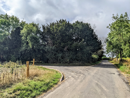
Head S on Cottered footpath 42 for 610m until you reach Throcking Road in
Throcking (location -
https://w3w.co/hence.conductor.wings), see image below.
 |
| Turn right on Throcking Road then take the lane on the left |
13: Turn right on Throcking Road then head SW for 45m until you reach a lane on the left (location -
https://w3w.co/fidget.daffodils.steeped), see image above.
Turn left on the lane then head SSE for 65m until you reach
Holy Trinity church on the right (location -
https://w3w.co/harshest.castle.fled), see image below. According to a local website:
"The church has structure from two distinct eras, the oldest is the western tower which has its origins in the 13th century albeit added to in the 17th. The remainder of the church dates from the Perpendicular period of late 14th or early 15th centuries".
 |
| Holy Trinity church Throcking |
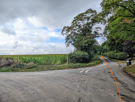
Continue heading S on the lane for 230m until the lane bends to the right to reach a junction (location -
https://w3w.co/coconut.sniff.enhances), see image below.
 |
| Keep right at the junction ignoring the lane on the left |
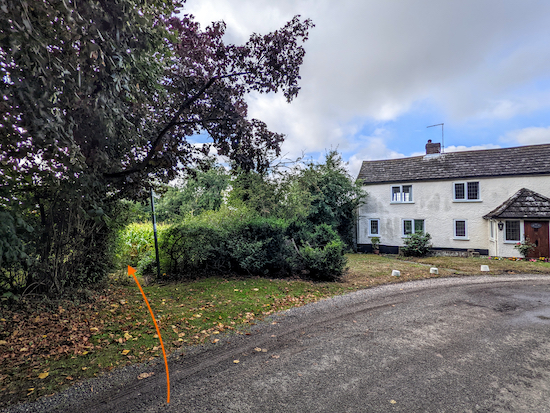
Keep right at the junction then head WSW for 210m until the lane reaches a footpath on the left just before a cottage (location -
https://w3w.co/acquaint.meanest.disband), see image below.
 |
| Take the footpath on the left just before a cottage |
14: Take the footpath on the left just before the cottage then head W on Cottered footpath 31 for 550m until you reach a junction (location -
https://w3w.co/udder.applauded.winded), see image below.
 |
| At the junction take the left fork after the tree |
15: At the junction take the left fork after the tree then head SW for 210m across a fenced-off livestock field to reach the hedgerow and another arable field (location -
https://w3w.co/intestine.risen.troubled), see image below. There are signs along this stretch asking dog owners to keep their pets on a lead.
 |
| Head SW across the next field until you reach the hedgerow |
16: Head SW across the next field for 370m until you reach the hedgerow (location -
https://w3w.co/deeply.strikers.sailing), see image below.
* When we walked this route the field had just been harvested and the right of way wasn't clear, so I have marked it with an orange arrow on the image above.
 |
| Cross a footbridge then head W with the hedgerow on the right |
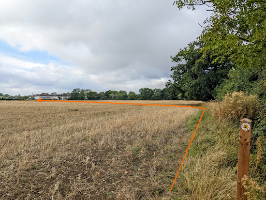
17: When you reach the hedgerow, cross a footbridge then head W, still on Cottered footpath 31, with the hedgerow on the right and field on the left for 150m until you reach a marker post then an oak tree on the right at which point Cottered footpath 31 bends left to cross the field (location -
https://w3w.co/balloons.graceful.incorrect), see image below.
 |
| When you reach the oak tree on the right cross the field to the left |
When you reach the oak tree on the right turn left then cross the field heading SW for 210m aiming to the left of the cottages in the distance and continuing until you reach the A507 Baldock Road (location -
https://w3w.co/proves.parading.udder), see image below.
 |
| Cross Baldock Road then take the footpath beside the houses |
18: Cross Baldock Road then take Cottered footpath 30 and head SW behind houses for 350m until you reach a lane (location -
https://w3w.co/hillside.reception.trickles).
19: Cross the lane then take the footpath on the opposite side (location -
https://w3w.co/sublime.striving.financial), see image below.
 |
| Cottered footpath 7 |
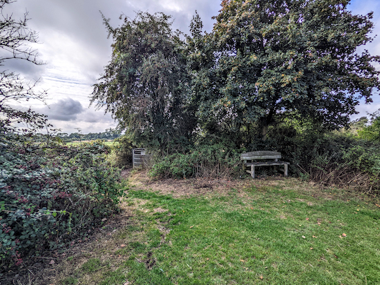
Head SW on Cottered footpath 7 with playing fields on the right and hedgerow on the left for 210m to a junction just beyond a play area (location -
https://w3w.co/scoping.monopoly.employers), see image below.
 |
| Turn right at the junction on Cottered footpath 10 |
20: Turn right at the junction on Cottered footpath 10 then follow it N for 200m to the A507 (location -
https://w3w.co/commenced.forgotten.react). Turn left on the A507 then head W for 45m back to The Bull and the starting point (location -
https://w3w.co/trades.tungsten.butlers).
Interactive map


Hi David wow this walk is different first walk I’ve done of yours which was totally fields No Woods or Tracks and ten out of ten for you doing it after ploughing 👏🏻👏🏻 all fields were dry today . Entrance to the field next to The Bull totally flooded so used the pubs garden to access and thank you for Orange arrows and Ellie’s elegant hand signals most helpful. Thanks .
ReplyDeleteIan R.
Well done surviving that one, Ian. A real challenge. So many fields and so much mud. Respect. :-). David
DeleteWe did this walk last week (late May) and after point 14 we entered a field of (I think) Rapeseed to find no path forward at all. I think the farmer must have planted over the paths. We had to rejoin the road and complete the walk on tarmac. Other than that, it was a very nice walk indeed, some gentle rolling hills, woods and peaceful too. I note the free parking in the middle of Cottered.
ReplyDeleteSo sorry to hear you were unable to complete the walk because of a blocked public right of way. Farmers are legally bound to reinstate all public rights of way within 14 days. Would you be able to report it to Hertfordshire County Council so they can speak to the farmer and get the right of way reinstated? Below is a link to the online form. https://www.hertfordshire.gov.uk/services/highways-roads-and-pavements/report-a-problem/report-a-highway-fault/public-rights-of-way/public-rights-of-way.aspx
DeleteCan confirm that between points 14 and 15 the crop is very much still there and therefore the path isn't. Managed to navigate our way along the tractor tracks turning left, then right and right again at the top of the field to get to point 15, but it wasn't easy. Also there is no path marked between 16 and 17(but the field is fallow), and at 17 the farmer has planted a sweetcorn crop over the path so you need to skirt around the field. In no way does this reflect badly on Hertfordshire Walker, nor does it take away from what is a really good walk, you just need to be prepared for a short detour.
ReplyDeleteThanks for the detailed update on the blocked public rights of way. Would you be able to report the incidents directly to Hertfordshire County Council. They have an online form that is easy to fill in. Thanks
Deletehttps://www.hertfordshire.gov.uk/services/highways-roads-and-pavements/report-a-problem/report-a-highway-fault/public-rights-of-way/public-rights-of-way.aspx
Have reported.
Delete