4.8 miles (7.7 km) with 95m of total ascent
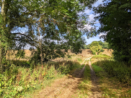 |
| The route between points 11 & 12 |
This walk explores the rolling hills between Walkern and Ardeley along well defined footpaths, bridleways, and byways. There are two pubs and two cafe's in Walkern at the start and finish point, and a pub and cafe in Ardeley close to the halfway point.
The route crosses a livestock field and there are a number of signs along the way urging dog owners to keep their pets on a lead.
Getting there
There are bus stops in Walkern served by the number 38 bus. You can check bus times at
Intalink.
Fly through preview of walk
If you want to check what sort of landscape you will be crossing before you set off on this walk you can view a short 3D video of the route below. It's created using the free version of
Relive.
Directions
 |
Map for Walk 207: Walkern East Loop
Click on the map for a larger version
Created on Map Hub by Hertfordshire Walker
Elements © Thunderforest © OpenStreetMap contributors
There is an interactive map below the directions |
Those with GPS devices can download
GPX or
KML files for this walk. We've added
What3Words location references for those who use that system. If you print these walks you might want to use the green
PrintFriendly icon at the bottom of these directions to delete elements such as photographs.
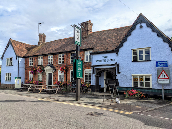 |
| The White Lion, Walkern |
1: With your back to
The White Lion on High Street Walkern (location -
https://w3w.co/snowstorm.suitcase.editor) turn left then head S continuing until you reach a garage on your left (location -
https://w3w.co/cropping.fuses.trusts).
2: Turn left immediately after the garage on Walkern
footpath 12 then head E for 75m, SSE for 55m, then cross the River Beane on a bridge on your left (location -
https://w3w.co/warms.slug.conforms), see image below.
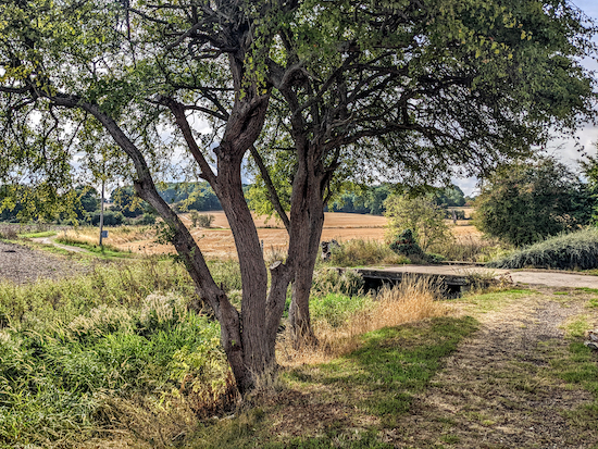 |
| Cross the bridge then head SE on Walkern footpath 12 |
Cross the bridge then head SE, still on Walkern footpath 12, for 144m, ignoring a path on the left and continuing until you reach a junction (location -
https://w3w.co/scales.stated.daytime), see image below.
 |
| Turn left at the junction on Walkern footpath 13 |
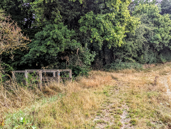
3: Turn left at the junction on Walkern footpath 13 then head ENE for 275m, with the hedgerow and ditch on your left and a field on your right until you reach woodland and a wooden footbridge on the left (location -
https://w3w.co/schematic.sandbags.blizzard), see image below.
 |
| Cross the footbridge then head NNE, still on Walkern footpath 13 |
4: Cross the footbridge then head NNE, still on Walkern footpath 13, for 75m with the woodland on the right and field on the left until the path bends right at the top of the woodland (location -
https://w3w.co/usage.handyman.chuckle).
Walkern footpath 13 then heads ESE with the woodland on the right and field on left for 260m until it reaches a junction (location -
https://w3w.co/troll.jets.clerics), see image below.
 |
| Cross the next field to reach woodland on the other side |
5: Keep heading straight and ESE at the junction crossing the next field, still on Walkern footpath 13, to reach woodland on the far side (location -
https://w3w.co/nitrate.warnings.nags), see image below.
 |
| Enter the woodland on Walkern footpath 13 |
6: Enter the woodland via wooden steps then continue through the woodland for 70m emerging at a field (location -
https://w3w.co/format.slicing.rolled), see image below.
 |
| Cross the field on Walkern footpath 13 heading for the lone tree |
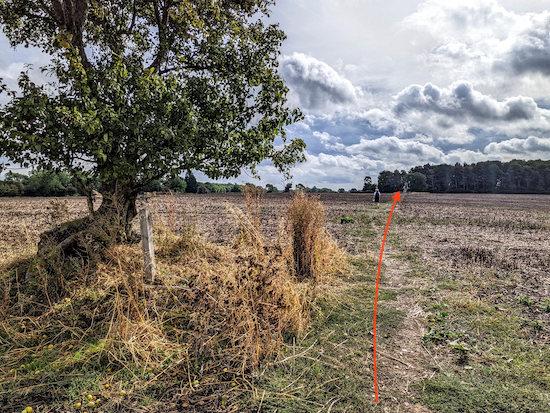
Cross the field on Walkern footpath 13 heading SE for 140m aiming for the right of a lone tree in the middle of the field (location -
https://w3w.co/soulful.hobbit.slugs).
* When we tested this walk on 5 September 2022 the field had just been ploughed so we relied on our satellite navigation to find the right route (demonstrated by Ellie on the images above and below).
 |
| Head SE across a field towards a dead oak |
7: When you reach the tree continue heading SE across a field for 240m towards a dead oak tree (location -
https://w3w.co/cakes.organic.prospered), see image below.
 |
| Continue past the dead oak for 35m until you reach a track |
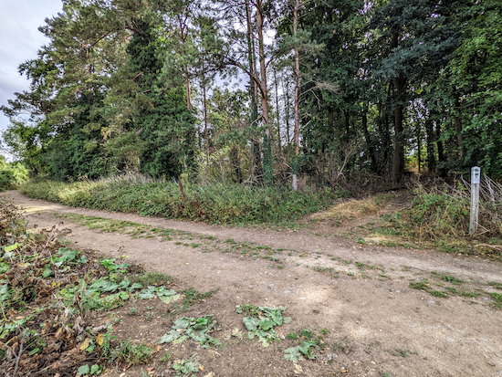
Keep to the right of the dead oak then continue for 35m until you reach a track in front of woodland (location -
https://w3w.co/houseboat.panics.removals), see image below.
 |
| Turn left on Walkern bridleway 36 |
8: Turn left on Walkern
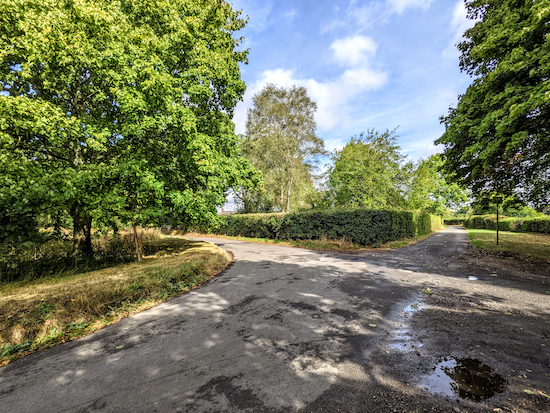
bridleway 36 then head NE for 60m until you reach a lane (location -
https://w3w.co/surgical.ushering.stylist). Turn left on the lane then head NE for 210m to a crossroads at Bassus Green (location -
https://w3w.co/charm.essential.gravest), see image below.
 |
| Turn left at the crossroads then head NW |
9: Turn left at the crossroads then head NW for 280m. As you walk this lane take a look at the cute cottage on the right (location -
https://w3w.co/bystander.scanty.paddle), see image below.
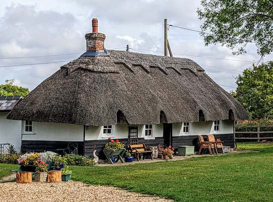 |
| Cottage at Bassus Green |
10: Continue along the lane until you reach a byway on the right (location -
https://w3w.co/scrap.bandstand.trickles), see image below.
 |
| Turn right on Walkern BOAT 29 then head NE |
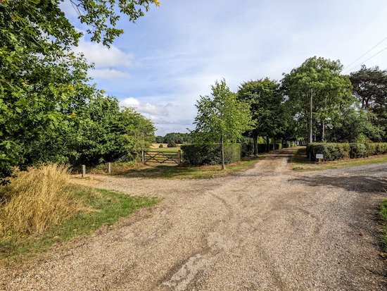
Turn right on Walkern BOAT 29 (
byway open to all traffic) then head NE for 280m to a junction (location -
https://w3w.co/workshops.breakaway.discussed), see image below.
 |
| Turn left on Walkern UCR 3 then head N |
11: Turn left on Walkern UCR 3 (
unclassified unmetalled county road) then head N for 440m to a junction (location -
https://w3w.co/composes.pram.wasp), see images below.
 |
| Turn right on the junction, still on Walkern UCR 3 |
 |
| Head E, still on Walkern UCR 3 for 120m to a junction |
12: Turn right on the junction, still on Walkern UCR 3, then head E for 120m to junction (location -
https://w3w.co/texted.century.surpassed), see image below.
 |
| At the junction head ESE, now on Ardeley bridleway 9 |
At the junction ignore the turn on the left and turn slightly to your right, now on Ardeley bridleway 9. This is a particularly attractive bridleway which passes an information board for
Church Farm Ardeley on the left (location -
https://w3w.co/races.carriage.joked), see image below. According to its website Church Farm is:
"... a not-for-profit farming, food, care and education farm. Our aim is to enhance the countryside, provide people with special needs the opportunity to learn and grow, conserve wildlife and farm ecologically. "
 |
| The information board for Church Farm - click here for larger version |
 |
| Ardeley bridleway 9 |
Continue heading E on Ardeley bridleway 9 for 740m to a junction (location -
https://w3w.co/draining.lofts.fuzz), see image below.
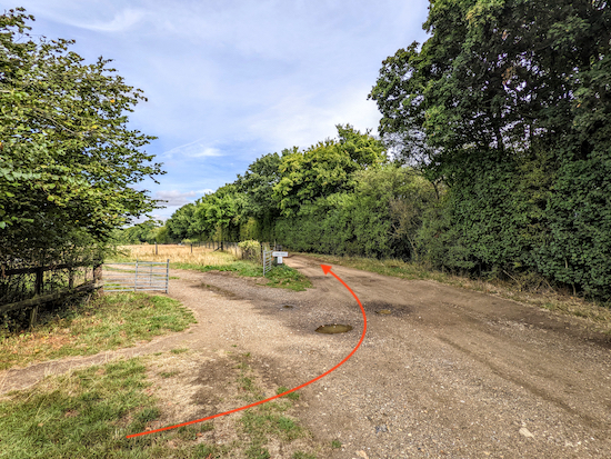 |
| Turn left at the junction then head N on Ardeley BOAT 4 |
13: Turn left at the junction then head N on Ardeley BOAT 4 (byway open to all traffic) for 590m until the path splits (location -
https://w3w.co/cabbages.salmon.clearcut), see image below.
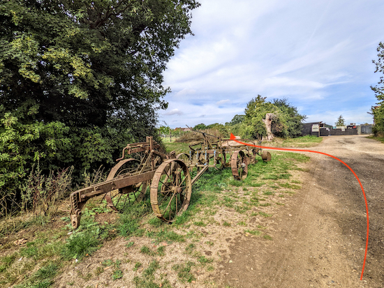 |
| Follow Ardeley BOAT 4 as it bends left |
Continue on Ardeley BOAT 4, as it bends left, now heading NW for 170m until it meets School Lane (location -
https://w3w.co/freshen.lays.yachting). Head N on School Lane for 160m until you reach a T-junction (location -
https://w3w.co/observer.noun.goods).
* When you reach Ardeley you have the option of turning right to visit The Jolly Waggoner (location - https://w3w.co/variety.dugouts.lamppost) or the Church Farm Shop & Cafe (location - https://w3w.co/tasks.ahead.polka). Both are 100m to the right when you reach the lane (location - https://w3w.co/hologram.guard.conducted). The pub was closed when we walked this route so we had a really good coffee and bacon roll at Church Farm.
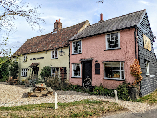 |
| The Jolly Waggoner, Ardeley |
 |
| Church Farm shop and cafe, Ardeley |
14: If you don't take the detour to the pub or the cafe, turn left then head W along the lane passing a terrace of thatched cottages on the right (location -
https://w3w.co/masterpiece.beast.crashing), see image below.
 |
| Terraced thatched cottages in Ardeley |
Continue heading W for 340m to junction (location -
https://w3w.co/basher.bandaged.constants), see image below.
 |
| Take Ardeley bridleway 38 then head W |
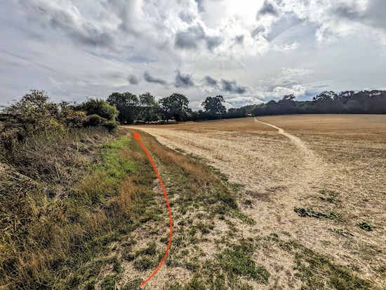
15: When you reach the junction take the track on the bend, Ardeley bridleway 38, see orange arrow on the image above. Keep heading W and straight ahead diagonally across a field, see image below.
 |
| Cross the field heading WNW (in the direction of the orange arrow) |
Cross the field heading WNW (see direction of orange arrow on the image above) to reach a gate (location -
https://w3w.co/claim.doses.restored), see image below.
 |
| Go through the gate then continue heading W on Ardeley bridleway 38 |
Go through the gate then continue heading W on Ardeley bridleway 38 with the hedgerow on the left and field on the right for 650m to a junction (location -
https://w3w.co/hampers.disposing.gobbles), see image below.
 |
| Turn left at the junction then head S on Walkern restricted byway 16 |
16: Turn left at the junction then head S on Walkern restricted byway 16 for 510m, with the hedgerow on the left and field on the right, until you reach a footpath on the right (location -
https://w3w.co/princely.batches.frames), see image below.
 |
| Turn right at the junction on Walkern footpath 15 |
17: Turn right at the junction on Walkern footpath 15 then head SW for 240m until the path bends left as it passes the churchyard of the
church of St Mary The Virgin (location -
https://w3w.co/rips.soothing.barbarian), see image below.
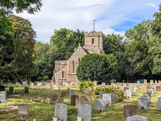 |
| The church of St Mary the Virgin, Ardeley |
The path now bends left for 35m to reach a lane called Church End (location -
https://w3w.co/makeovers.darker.almost).
18: Turn right on Church End then head W for 110m until you reach a footbridge crossing the River Beane (location -
https://w3w.co/sprinkle.intruders.bounded), see image below.
 |
| The footbridge over the River Beane at Church End |
Immediately after crossing the footbridge turn left on Walkern footpath 35 (location -
https://w3w.co/giants.guideline.named). Immediately after the turn there is an information board with a potted history of Walkern.
Click here or on the image below for a larger version.
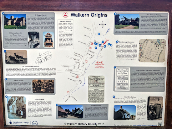 |
| The information board on the left after crossing the River Beane |
Head S on Walkern footpath 35 for 80m until you reach a junction on the right (location -
https://w3w.co/dive.agency.putty), see image below.
 |
| Turn right on Walkern footpath 18 then WSW to High Street |
19: Turn right on Walkern footpath 18 then head WSW for 280m across a field until you reach High Street, Walkern. Turn left on High Street then head S for 30m to the starting point outside The White Lion.
* There are a number of options for refreshments in Walkern including The White Lion (location - https://w3w.co/though.shaky.geese), The Brewery Tearoom (location - https://w3w.co/grandest.situation.solar), and The Yew Tree pub (location - https://w3w.co/tint.hurricane.spoiled) which was seeking new tenants when we last updated this walk.
Interactive map


Is there anywhere to park?
ReplyDeleteWe found a place on High Street, but it's tight. There are places but I never recommend parking places having fallen foul of some residents in another village who took exception to me suggesting people park in their road (despite there being no restrictions). So I don't mention parking (also because restrictions might be introduced after the walk is published). But, to answer your question, there are places to park.
DeleteDavid
Did this walk this morning and enjoyed it very much. It was very muddy just before Bassus Green after the heavy rain we have had, but still doable at the moment.
DeleteHi Beryl, thanks for the update. David
DeleteHi Dave lots to look at on route very enjoyable Thank You. At point 13 you mentioned about ploughed field . Us Walkers have now flattened it down so no direction problems. IR.
ReplyDeleteThanks Ian, I can always rely on you to reinstate a path over a ploughed field. :-)
DeleteThoroughly enjoyed this walk. We parked at St Mary's Church then walked to the start point. Fabulous rolling countryside views. Some nice welcome shady parts too. A nice cold lemonade and lime at The White Lion at the end.
ReplyDeleteGlad you enjoyed it. It's always nice when people modify routes. Thanks for the feedback.
DeleteAbsolutely love the web, the only thing what is missing is post codes. For people to try it out for the first time is a bit hard to navigate. I’m going to take the advise from above and park at the church car park. Thanks again for a great web for lovely walks
ReplyDeleteHi, thanks for the feedback. We don't use postcodes because they cover too wide an area to be accurate in terms of finding a particular path or turning point. Instead we use What3Words references which are far more accurate and focus on an exact 3m square area. If you haven't already done so please join our friendly Hertfordshire Walker Facebook group where people are sharing tips and photographs from their walks. David
Deletehttps://www.facebook.com/groups/hertfordshirewalker
Just completed this walk and really enjoyed it - although Walkern is familiar to us, we have discovered new countryside and some fabulous views across rolling countryside. Directions and accompanying pictures were very easy to follow.
ReplyDeleteJust a minor point: the text mentions that there are two pubs in Walkern, but currently it's only the White Lion that's open; the Yew Tree has been closed for nearly two years now and it still looked very shut today.
This is a wonderful website for walkers and we're looking forward to trying some of the many other walks listed.
Hi Paul, glad you enjoyed the walk. And thanks for the feedback and the update on the Yew Tree. I will check it out and update the directions. if you haven't already done so please consider joining our friendly Facebook group where fellow walkers are sharing their walking experiences and photos. David :-)
Deletehttps://www.facebook.com/groups/hertfordshirewalker
Hi Paul, it looks like the McMullen Brewery is advertising for new tenants for The Yew Tree. I have emailed the brewery to check this is still active. Thanks for letting me know.
Deletehttps://www.mcmullens.co.uk/tenancy-pub/the-yew-tree/
David
Hi Paul, McMullen Brewery tells me they are still looking for a new tenant for the Yew Tree.
ReplyDelete