4 miles (6.5 km) with 72m of total ascent
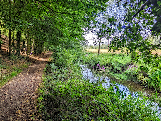 |
| Stapleford footpath 3 running alongside the River Beane |
We really enjoyed mapping and testing this walk because of the variety of countryside in such a short distance. This walk starts in the car park of the
Waterford Heath Nature Reserve, then heads north-east to Chapmore End. The route then loops back over arable land with great views then returns along the banks of the River Beane before crossing the northern section of Waterford Heath.
The starting point is a car park off Vicarage Lane which is two miles N of Hertford North station by road. At the time we tested this walk in early September 2022 the car park was free of charge.
There are several signs along the way asking dog owners to keep their pets on a lead. At one point the route crosses a livestock field where sheep were grazing when we walked the route.
Directions
 |
Map for 206: Waterford Heath North-East Loop
(click here or on the map for larger version)
Created on Map Hub by Hertfordshire Walker
Elements © Thunderforest © OpenStreetMap contributors
There is an interactive map below these directions |
Those with GPS devices can download
GPX or
KML files for this walk. We've added
What3Words location references for those who use that system. If you print these walks you might want to use the green
PrintFriendly icon at the bottom of these directions to delete elements such as photographs.
1: From the Waterford Heath car park on Vicarage Lane (location -
https://w3w.co/stow.belts.coast) head to the eastern corner of the car park to the right of the entrance. Take a footpath that heads E behind a new housing estate (location -
https://w3w.co/nature.tigers.combining), see image below.
 |
| Take the footpath that heads E out of the car park |
Head E then NE on this footpath for 140m at which point the path bends to the left (location -
https://w3w.co/vows.loving.couches) then heads N for 105m to two sections of fence on the right marking the way out of Waterford Heath to Sacombe Road (location -
https://w3w.co/hush.vines.famous), see image below.
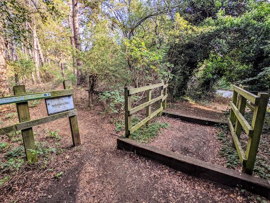 |
| Turn right to reach Sacombe Road |
2: Cross Sacombe Road then take Hertford
footpath 6 (location -
https://w3w.co/boot.united.quest), see image below.
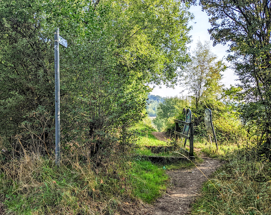 |
| Cross Sacombe Road then take Hertford footpath 6 |
Follow Hertford footpath 6 NE for 160m to a junction (location -
https://w3w.co/port.loudly.flash). This is a lovely stretch of countryside, see image below.
 |
| Hertford footpath 6 |
When you reach the junction keep heading NE, now on Hertford
restricted byway 8, for 155m to a junction (location -
https://w3w.co/tins.sums.truck), see image below.
 |
| Ignore the footpath on the right and keep heading NE and uphill |
3: Ignore the footpath on the right and keep heading NE and uphill, now on Bengeo Rural
bridleway 12, for 380m to a junction (location -
https://w3w.co/beam.spend.score), see image below.
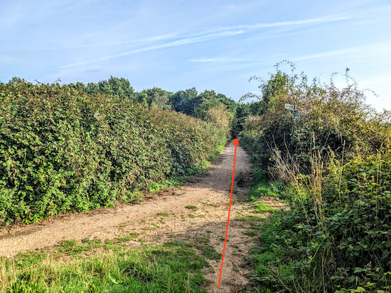 |
| Continue heading NE at the junction |
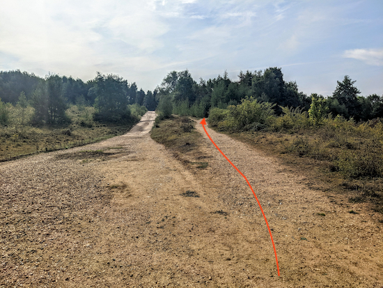
4: Continue heading NE at the junction (see direction of the orange arrow) for 135m until the byway bends right (location -
https://w3w.co/payer.drop.violin) then heads ENE for 360m to a junction of paths (location -
https://w3w.co/wisdom.prep.darker).
5: Continue heading NE on Bengeo Rural BOAT 22 (
byway open to all traffic) for 230m until you reach a lane leading to Chapmore End (location -
https://w3w.co/honey.rear.pipes).
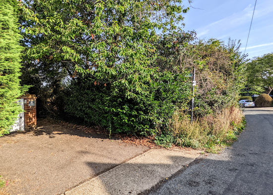
6: Head NE along the lane for 270m until you reach a footpath on the left (location -
https://w3w.co/dice.from.person) just before
The Woodman (location -
https://w3w.co/third.scale.models) see images below. The Woodman has a cafe called
The Conservatory.
 |
| Turn left on Bengeo rural footpath 9 just before The Woodman |
 |
| The Woodman at Chapmore End |
7: Turn left on Bengeo rural footpath 9 then head NW for 580m until you reach woodland on the left (location -
https://w3w.co/brand.lower.moon), see image below.
 |
| Turn right at the woodland on Bengeo Rural footpath 8 |
8: Turn right when you reach the woodland (and just before a bench) on Bengeo Rural footpath 8, then head N for 110m to a lane (location -
https://w3w.co/insist.strike.spit).
9: Turn left on the lane then head W for 230m until you reach a junction with a footpath on the opposite side of the road (location -
https://w3w.co/trials.sport.quit).
10: Cross the road and take this footpath. This short footpath is interesting because in the space of 270m it crosses three Hertfordshire parishes. It starts as Bengeo Rural footpath 15 then after 40m becomes Stapleford footpath 11, then for the final 40m is Sacombe footpath 19, see image below.
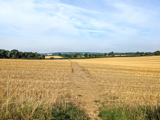 |
| The footpath that crosses three parishes in 270m |
11: When you reach the other side of the field (location -
https://w3w.co/fight.fired.above), turn right on Sacombe footpath 15. Don't be put off by a sign which reads 'Private road to Southend Farm Authorised access only', the lane is a public right of way and you are entitled to walk it.
Head N on Sacombe footpath 15 for 300m until you reach a footpath on the left (location -
https://w3w.co/causes.origin.shorts), see image below.
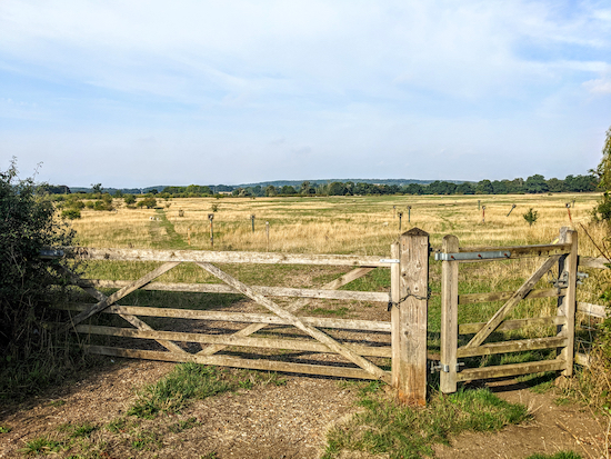 |
| Turn left on Sacombe footpath 17 then head SW |
12: Turn left on Sacombe footpath 17 then head SW for 410m until you reach Church Lane (location -
https://w3w.co/bunk.lifts.goats). This footpath has been rerouted, so if you have an Ordnance Survey app or are using an Ordnance Survey map you will notice that the starting point for Sacombe footpath 17 is in a different place.
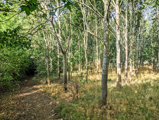
13: Turn right on Church Lane then take a permissive path on the right which avoids having to walk on the road around a narrow bend, see images below.
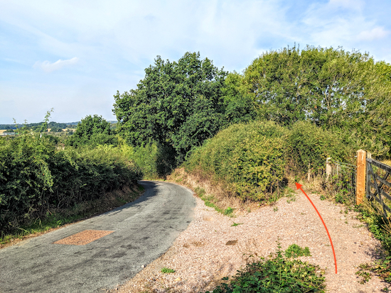 |
| The permissive path runs parallel to Church Lane |
 |
| The permissive path running parallel to Church Lane |
Head W along the permissive path for 110m before it rejoins Church Lane beyond the bend. Continue heading W along Church Lane for 240m until you reach a footpath on the left (location -
https://w3w.co/regard.shots.caged), see images below.
 |
| Turn left on Stapleford footpath 3 |
 |
Turn right on Stapleford footpath 3 before you reach the church
|
14: Turn left on Stapleford footpath 3 then turn right before you reach the church, see footpath on the image above. Follow Stapleford footpath 3 SE alongside the River Beane for 1km to a junction (location -
https://w3w.co/crass.frosted.play), see image below. There are a couple of benches along this pretty footpath for those who take a packed lunch, or just want to give their legs a rest.
 |
| Head SSW at the junction still on Stapleford footpath 3 |
15: When you reach the junction turn right then head SSW for 150m, still on Stapleford footpath 3, until you reach a lane (location -
https://w3w.co/candle.ladder.wooden). Continue heading SSW along the lane for 215m until you reach Bush Mills Lane (location -
https://w3w.co/items.rubble.regard)
16: Turn left on Bush Mills Lane then head SSE for 50m until you reach a footpath on the right (location -
https://w3w.co/cooks.nurse.purely), see image below.
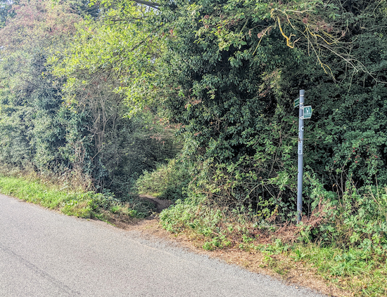 |
| Turn right on Stapleford footpath 2 |
17: Turn right on Stapleford footpath 2 then head S for 130m until you reach a junction on the left (location -
https://w3w.co/smoke.hurt.fades), see image below.
 |
| Turn left at the junction then climb the steps to Waterford Heath |
18: Turn left at the junction then climb the steps heading E for 70m until you reach a gate leading to Waterford Heath (location -
https://w3w.co/belly.festivity.yappy), see image below.
 |
| From the gate head S for 90m until you reach the old quarry road |
19: From the gate head S for 90m until you reach the old quarry road (location -
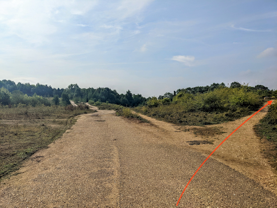
https://w3w.co/others.warns.cargo). Head S along this paved road for 125m until you reach a path going off to the right (location -
https://w3w.co/pilots.hangs.seats), see image below.
 |
| Turn right then head SW for 50m to visit the art work |
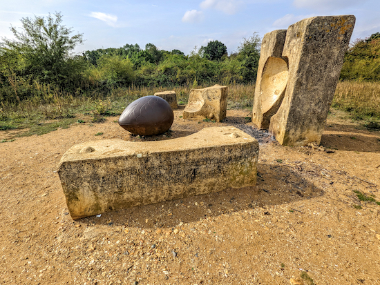
20: Turn right then head SW and uphill (see orange arrow on image above) for 50m to visit a piece of artwork by the sculptor Andrew McKeown titled '
Breaking The Mould'. According to the artist's website:
"Breaking the Mould takes the form of a giant seed, which has emerged, from an industrial mould. The mould is old and has been broken. The sculpture represents new life and growth emerging from industrial decline. The six piece cast stone and iron sculpture was installed as a 'Marker' for each of the 21 Changing Places regeneration sites across England and Wales."
 |
| 'Breaking The Mould' by Andrew McKeown |
 |
| 'Breaking The Mould' by Andrew McKeown |
After visiting the sculpture head SE and downhill for 70m to a junction (location -
https://w3w.co/dads.flag.sage).
 |
| Keep right at the junction then head S then SE back to the car park |
21: Keep right at the junction (see image above) then head S then SE for 230m back to the car park.
This walk is dedicated to Buster, a lovely Staffordshire Bull Terrier, who belonged to our friends Jenny and Andrew. They told us Buster used to love running up and down the hollows on the site of the old quarry between points 2 & 4 on this walk.
 |
| Buster - b: 20 April 2000 d: 16 November 2014 |
We have two other walks from the Waterford Heath car park. They are:
Driving to the car park
We recommend you approach the car park on Vicarage Lane from the east and not the west.
If you approach from the west the lane is narrow with few passing places and there is a sharp bend over the railway bridge where we got trapped in a traffic jam caused by an articulated truck getting stuck. It took half an hour to clear.
A local resident told us it is far better to approach the car park via Bulls Mill Lane, Sacombe Road, then Vicarage Lane. They were right. We rerouted that way. I have created a map (below) to show the recommended route to the car park in green and the narrower route in red. Click on the map for a larger version.
 |
Recommended route to car park in green
Created on Map Hub by Hertfordshire Walker
Elements © Thunderforest © OpenStreetMap contributors |
Click here to return to the start of the directions for the walk.
Warning - mini rant coming up: When we walked one of the footpaths along this route we had to get out of the way of cyclists coming towards us and from behind. I mentioned to them that it was a public footpath and was told "No it's not".
Although it's great to see people enjoying the countryside, cyclists are not allowed on public footpaths. The rules are clear when it comes to riding a bicycle on a public footpath:
"You do not have the right to use a bicycle, or even to wheel a bicycle along them. This is not a criminal offence, but a trespass against the landowner."
I doubt many cyclists read this site, but, if you are a cyclist who insists on cycling on footpaths please at least dismount when approaching walkers and don't go so fast as to put those walking in danger, especially along narrow footpaths and on bends.
Some walkers may not be able to move out of the way that easily, particularly if the footpaths are narrow.
Thanks.
There were several 'No Cycling' signs along this route which suggest cycling on public footpaths might be a bit of a problem in this area, so please take care.
 |
| Several paths had 'No Cycling' notices |
Interactive map


Lovely walk with views and and wooded trails. Realised I knew where I was when I reached the Church at Stapleford having walked in the opposite direction on a previous walk. Just one thought carry a stick at beginning and end trails as resent rain has given all the Nettles a second wind . Thank You.
ReplyDelete.IR.
David, my WGC U3A walking group did this walk Thurs 30 March and really enjoyed it. Thanks. Everyone wanted to know what the small posts with fans on top at the entrance to the sheep field on Southend Farm are (pic 12 on your description). Do you know?
ReplyDeleteHi, I seem to remember some correspondence about this in the past, but I can't find what was written. Something about air vents after the quarries were filled in, but I am not sure. Sorry. David
DeleteOK Thanks anyway David.
DeleteLovely easy circular walk. Starts at car park at top of the hill with a view. Sun was shining, lots of birds and butterflies. Very little mud. Downloading the interactive map onto mobile genius. Thank you Rebekah
ReplyDeleteHi Rebekah, so glad you enjoyed it. It is a lovely walk. We often revisit it. David
DeleteHeard of this place through a dog walker last week so decided to investigate! As i'm tech-stupid, i couldn't download a map so wasn't sure whether we were at the Heath or in the quarry...( We entered behind the car park). Walked around until we found the egg sculpture & further on we thought we'd found the picnic area, so we sat at the table & ate our lunch..we were actually at the bottom of someone's garden!! ( Barn conversions i think ). We walked & came out onto the main road, found a bridlepath & entered a massive place, possibly the heath? with Molewood? At the end of the walk we found ourselves across the road of the car park.So wherever we were, it was a beautiful place with stunning scenery, but next time i'l go with someone who knows the route!
ReplyDeleteWow, quite an adventure. Did you not follow our directions at all? If you are not very technical you could always print the directions and delete any images or other elements you don't want to save paper and ink. This link will explain how it's done. David https://www.hertfordshirewalker.uk/p/tips.html#printing
DeleteI’m a runner, walker and cyclist - agree with comments about respecting others using shared paths and trails. This is a great resource. Thank you
ReplyDeleteThanks for that feedback. If you haven't already done so please consider joining our friendly Facebook group where walkers (and some runners) are sharing their experiences and photos of the Hertfordshire countryside.
Deletehttps://www.facebook.com/groups/hertfordshirewalker
Did this walk today and loved the variety of the countryside - arable fields, woods, riverside path wild flower meadows and country lanes. It was very humid so the wooded paths were our favourite! We are thinking of repeating the walk when it is a bit cooler. For info the Woodman is only.open during the day from Thursday to Sunday so we missed a half way refreshment stop.
ReplyDeleteHi Susie, glad to hear you enjoyed the walk. It is a nice route. Sorry The Woodman was closed when you got there. I add links to all pubs and cafes mentioned on the routes so it's worth checking opening hours if you do decide to repeating the walk in cooler weather. Thanks for the feedback.
DeleteFantastic walk and we really enjoyed the mix of terrain. The paths between points 2 and 4 are a bit overgrown at the moment. Passable but in danger of being quite nettley if you're in shorts!
ReplyDeleteThanks for the tip about the nettles, a problem this time of the year. I hope you didn't get stung.
DeleteIs there any animals on this route?
ReplyDeleteHi, the route follows footpaths where you might meet dogs, and bridleways where you might come across horses. Also, as you will know by reading the directions the route crosses some livestock fields where you might meet sheep or cattle.
Delete