5.4 miles (8.8 km) with 84m of total ascent
 |
| Stile and gate between points 4 & 5 |
This walk offers wide open views across the rolling countryside north of Walkern. The route crosses some livestock fields and, at one point, a field of horse jumps. It also crosses a number of arable fields. The starting point is 4.5 miles ENE from Stevenage station by road.
Fly through preview of walk
If you want to check what sort of landscape you will be crossing before you set off on this walk you can view a short 3D video of the route below. It's created using the free version of
Relive.
Directions
 |
Map for Walk 195: Walkern North Loop
Click on the map for a larger version
Created on Map Hub by Hertfordshire Walker
Elements © Thunderforest © OpenStreetMap contributors
There is an interactive map below the directions |
Those with GPS devices can download
GPX or
KML files for this walk. We've added
What3Words location references for those who use that system. If you print these walks you might want to use the green
PrintFriendly icon at the bottom of these directions to delete elements such as photographs.
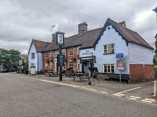 |
| The White Lion, High Street, Walkern |
1: With your back to
The White Lion on High Street Walkern (location -
https://w3w.co/snowstorm.suitcase.editor) turn right then head NNE for 30m until you reach a footpath on the right just beyond the pub car park (location -
https://w3w.co/bouncing.comment.wager). Take this path, Walkern footpath 18, then head ENE for 280m to a junction (location -
https://w3w.co/dive.agency.putty), see image below.
 |
| Turn left at the junction on Walkern footpath 35 |
Turn left at the junction on Walkern footpath 35 then head N for 70m to a lane called Church End (location -
https://w3w.co/impulsive.salsa.encourage).
2: Turn right on Church End, cross a footbridge over the River Beane, then head E for 120m until you reach a footpath on the left just beyond the church (location -
https://w3w.co/allies.waxing.opts), see images below.
 |
| The footbridge over the River Beane |
 |
| Walkern parish church on Church End |
 |
| Take the footpath on the left just beyond the churchyard |
Turn left on the footpath just beyond the churchyard then head NNE with the churchyard on your left for 40m until the path splits (location -
https://w3w.co/gates.unwanted.diverting), see image below.
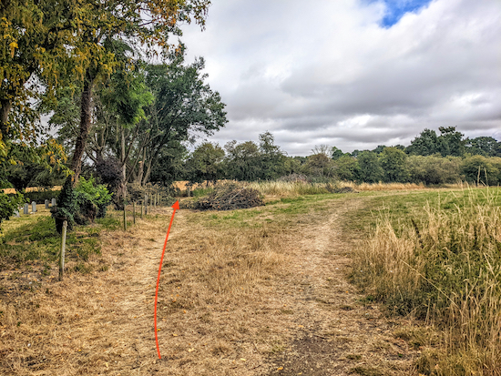 |
| Take the left fork, Walkern footpath 17, see orange arrow |
Take the left fork, Walkern footpath 17, then head NNE, with the churchyard on your left (see orange arrow on the image above). Continue for 55m until you reach a footbridge leading to a field (location -
https://w3w.co/heightens.invested.according), see image below.
 |
| Cross the footbridge then cross the field |
Cross the footbridge then continue across the field for 210m until you reach a hedgerow (location -
https://w3w.co/relieves.ladder.widgets) where you go through a gate then continue to head N, see image below.
 |
| Go through the gate then head N with the hedgerow on the right |
Continue heading N for 250m, still on Walkern footpath 17, until the path appears to fork (location -
https://w3w.co/torches.clever.aboard), see image below.
 |
| Keep to the left with the River Beane on your left |
Here you keep to the left, still on Walkern footpath 17, (see orange arrow on image above) and follow the path closest to the River Beane then continue heading N for 130m until the footpath goes through the hedgerow (location -
https://w3w.co/resorting.vegans.drones), see image below.
 |
| The point where Walkern footpath 17 becomes Ardeley footpath 42 |
At this point you will cross a parish boundary and the path you are on becomes Ardeley footpath 42, which you follow N for 910m with the hedgerow on the left and the field on the right until you reach a lane (location -
https://w3w.co/obligated.guard.husky), see image below.
 |
| Cross the lane then take Ardeley footpath 41 and head N |
3: Cross the lane then continue heading N, now on Ardeley footpath 41, for 280m ignoring footpaths on the right and left, until you reach a gate (location -
https://w3w.co/revamped.given.displays), see image below.
 |
| Continue through the gate on Ardeley footpath 41 |
Go through the gate then head NW, still on Ardeley footpath 41, for 100m until you reach the B1037 in Cromer (location -
https://w3w.co/masking.ranked.dorms), see image below.
 |
| Cross the the B1037 then take Ardeley footpath 40 |
4: Cross the B1037 then take Ardeley footpath 40 and head NW for 30m to a gate and a footpath junction (location -
https://w3w.co/blatantly.enrolling.bulldozer). Take the right fork, still Ardeley footpath 40, then head NW for 60m to a gate (location -
https://w3w.co/trombone.conquest.rated), see image below.
* The next two fields are set out as a cross country course for horse riding and is in use from the beginning of May until the end of October each year. The rights of way are not closed while an event is on, however signs are put on the gates asking walkers to take care and be aware that horses can be travelling at high speed. If horses bother you we have a detour to avoid these fields. Instead of turning right at the fork on Ardeley footpath 40, keep left on Ardeley footpath 44 then head NW for 550m until you reach a lane where you turn right then head N for 340m to rejoin the route at point 6.
 |
| Head NW on Ardeley footpath 40 to a gate |
If you don't take the detour you will now cross a field decked out with horse jumps for 240m to a junction (location -
https://w3w.co/ruffle.curl.animates), see image below.
 |
| Follow Ardeley footpath 40 across the field to a footbridge |
Follow Ardeley footpath 40 NW across a second field for 210m to a footbridge over the River Beane (location -
https://w3w.co/grace.join.inspected), see image below.
 |
| Cross the Rive Beane on Clothall footpath 22 |
5: Cross the Rive Beane, now on Clothall footpath 22, which you follow WNW for 220m to a lane (location -
https://w3w.co/rocky.remodels.sketching). Turn right on the lane then head N for 110m until you reach a byway on the left (location -
https://w3w.co/distilled.blocks.stumpy), see image below.
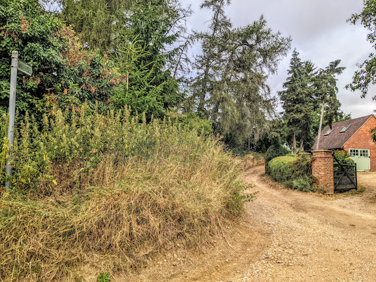 |
| Turn left on Clothall restricted byway 21 |
6: Turn left on Clothall
restricted byway 21 then head NW for 270m to a junction (location -
https://w3w.co/marmalade.manuals.equality), see image below.
 |
| Keep heading NW with the hedgerow on the right and field on the left |
Ignore the turn on the left and instead keep heading NW, still on Clothall restricted byway 21, with the hedgerow on the right and field on the left for 130m until you reach another junction (location -
https://w3w.co/slowness.secretly.things), see image below.
 |
| Turn left, still on Clothall restricted byway 21, then head WNW |
Turn left at the junction still on Clothall restricted byway 21 (see image above), then head WNW for 430m until you reach a gap in the hedgerow leading to a junction (location -
https://w3w.co/wriggled.romantics.bends).
7: Turn left on Weston BOAT 39 (
byway open to all traffic) then head S for 250m until you reach a junction (location -
https://w3w.co/juggled.acids.dusters), see image below.
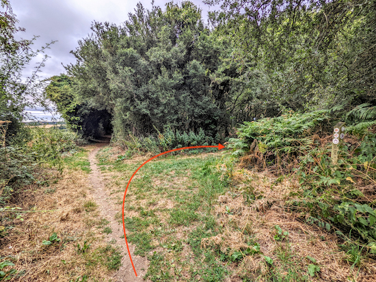 |
| Turn right at the junction on Weston bridleway 36 |
8: Turn right at the junction on Weston bridleway 36 then head W for 100m until you reach a fork (location -
https://w3w.co/luxury.revised.ditching), see image below.
 |
| Keep left at the fork then head WSW, now on Weston footpath 15 |
Keep left at the fork and head WSW, now on Weston footpath 15 for 1.2k until you reach a junction (location -
https://w3w.co/gladiators.fewest.expansion).
9: Keep left at the junction, now on Weston footpath 16, then head SW for 120m until you reach Dane End Lane (location -
https://w3w.co/charm.firm.reliving).
* If you want to visit The Rising Sun pub, turn right when you reach Dane End Lane then head N for 100m where you will find the pub on your right.
If you don't take the detour to the pub, turn left on Dane End Lane then head S for 130m to a bend and a footpath on the right (location -
https://w3w.co/sport.tastes.client), see image below.
 |
| Turn right on Weston footpath 32 |
10: Turn right on Weston footpath 32 then head SSE for 370m until you reach a footbridge leading to a field (location -
https://w3w.co/deflated.wrong.large), see image below.
 |
| Cross the field, still on Weston footpath 32 |
Cross the field then cut through the hedgerow and head SE with a farm on your left, still on Weston footpath 32, for 300m to a junction (location -
https://w3w.co/masterpiece.drew.noticing), see image below.
 |
| Turn right, then left, then right again still on Weston footpath 32 |
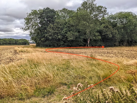
11: Turn right for 10m, then left for 30m, then right again (see orange arrow in image above), then head SSE, with Howell's Wood on your left and still on Weston footpath 32
for 320m until you pass the woodland. At this point the path you are on crosses the parish boundary (location -
https://w3w.co/callers.browsers.tasters) and becomes Walkern footpath 26, see image below.
 |
| Walkern footpath 26 heading SSE across the fields |
Follow Walkern footpath 26 down some steps then SSE across rolling fields for 1.1km to a track called Dovehouse Lane (location -
https://w3w.co/dwarf.amps.tonic), see image below.
 |
| Turn left on Dovehouse Lane then head SE back to the start point |
12: Turn left on the track called Dovehouse Lane then head SE for 540m until you reach High Street, Walkern (location -
https://w3w.co/hires.aviators.growth), turn right on High Street then head S for 80m back to the starting point.
* There are a number of options for refreshments in Walkern including The White Lion (location - https://w3w.co/though.shaky.geese), The Brewery Tearoom (location - https://w3w.co/grandest.situation.solar), and The Yew Tree pub (location - https://w3w.co/tint.hurricane.spoiled) which was seeking new tenants when we last updated this walk.
Interactive map


Hi Dave another lovely walk with shaded areas Thank you . Just for your information three sections of pathways have been ploughed over and very hard to walk on. Have sent you an email of these ,
ReplyDeleteThanks for the update Ian. I have received the images. I will post a note on Facebook to alert other walkers. I presume it's okay to use your images to warn others? Ploughed paths is a problem at this time of year as farmers turn over their fields after the harvest. Hopefully the paths will be reinstated soon. Dave
DeleteHi Ian,
DeleteI have posted a message on the Hertfordshire Walker Facebook page. Thanks for sharing the information.
https://www.facebook.com/hertfordshirewalker/posts/pfbid02vqsEJNWwrzkrFi7SbKtVDwLMjJrrzmGRbrotKhKrHRXzYQ5YLdddgeNFLAj2QBuVl
Dave
Yep no problem use pics
ReplyDeleteDid this walk today in a mixture of sunshine and showers. Parked in a layby near Point 3 and started from there. Lovely open walk with good views. Great bench to sit on donated by Fairclough Farm on the way where we sat and enjoyed the sunshine. Stopped at the Rising Sun for a baguette and a drink in their huge garden. A bit tricky walking across some of the ploughed fields but enjoyed the peace and quiet and the open countryside.
ReplyDeleteYes, ploughed fields (and paths) is a bit of a problem at this time of the year. I hope it didn't spoil your day. We haven't tried The Rising Sun; I hope I was good. Dave
DeleteHi Christine Johnson here. Did this walk yesterday & despite Storm Kathleen's best efforts to blow us over, an enjoyable walk. Saw very few people, lots of very open areas. Couple of mud baths still in place but fields were mostly dry. Also used the bench near Fairclough Farm bench for lunch. We did a couple of unplanned 'detours' - ended up next to The Rising Sun Pub rather than 100M down the road ( some kind of homing devise I suspect!) And due to our underestimating distances we took a track we thought was Dove House Lane at point 12 ending up a bit further along High Street but just walked back to start/ end from there so no problem. Be careful not to be 'seduced' by the very nicely painted waymarker in farm yard after the gate in Point 3 which points you to go 90' to that of the less obvious waymarker 41 in instructions.
ReplyDeleteHi Christine, thanks for all that feedback on the walk and the tips shared which I am sure will be helpful for others following the route. I loved the bit about your "homing device" taking you on a detour to The Rising Sun - I have the same inbuilt functionality. :-)
ReplyDelete