3.9 miles (6.3 km) with 103m of total ascent
 |
| The permissive bridleway between points 7 & 8 |
This walk includes sections of two walks in our collection. The route starts and finishes in the village of Lemsford and passes close to three pubs. The walk crosses a golf course so please take care when walking over the fairways. The starting point is 1.8 miles WSW from Welwyn Garden City station by road.
Getting there
There are bus stops close to the start of the walk (location -
https://w3w.co/herbs.venue.extend), which are served by the number 366 bus. Alternatively, you could start the walk at point 3 where there are bus stops close to The Crooked Chimney (location -
https://w3w.co/figure.hats.union) served by the numbers 366 and 610. You can check bus times at
Intalink.
Fly through preview of walk
If you want to check what sort of landscape you will be crossing before you set off on this walk you can view a short 3D video of the route below. It's created using the free version of
Relive.
There were two pubs in Lemsford,
The Sun Inn and the Long Arm and Short Arm, but the latter closed in March 2023 because of "
spiralling costs". There is also
The Crooked Chimney at point 3. We didn't meet any livestock on this walk but there are signs asking dog owners to keep their pets on a lead between points 4 and 6.
Directions
 |
Map for Walk 193: Lemsford West Loop
Click on the map for a larger version
Created on Map Hub by Hertfordshire Walker
Elements © Thunderforest © OpenStreetMap contributors
There is an interactive map below the directions |
Those with GPS devices can download
GPX or
KML files for this walk. We've added
What3Words location references for those who use that system. If you print these walks you might want to use the green
PrintFriendly icon at the bottom of these directions to delete elements such as photographs.
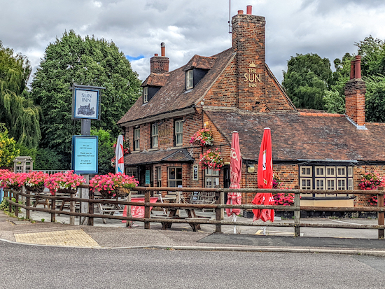 |
| The Sun Inn at the start of the walk |
1: With your back to the River Lea, and facing
The Sun Inn, turn right then head SW for 70m, with the river on your right and the road on your left, until you reach a bridge on the right (location -
https://w3w.co/shades.snap.swung), see image below.
 |
| Walkers are allowed to use the bridge to access footpaths |
A sign on the bridge reads "This private footbridge can be used by pedestrians to gain access to public footpaths. It is not a public right of way". Cross the bridge over the River Lea then head NW on Hatfield
footpath 57 for 60m to a junction (location -
https://w3w.co/backed.cycle.funded), see image below.
 |
| Turn left on Hatfield footpath 65 |
Turn left on Hatfield footpath 65, then head NW. After 50m you start to cross a golf course. Continue heading NW for 320m (looking out for golfers) to a point where the path splits (location -
https://w3w.co/limbs.spider.wiring), see image below.
 |
| Keep left at the fork, still on Hatfield footpath 65 |
Take the left fork then head NW for 110m, still on Hatfield footpath 65. You are still crossing a golf course so look out for golfers. Continue until you reach a track (location -
https://w3w.co/level.index.fool) and, beyond the track, a junction (location -
https://w3w.co/hiding.voice.loses) just before a stone bridge, see image below.
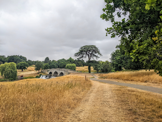 |
| Cross the track, then turn left on Hatfield footpath 59 and cross the bridge |
2: Turn left on Hatfield footpath 59 then cross the bridge. Once over the bridge head WSW and uphill, see the direction of the orange arrow on the image below. Again look out for golfers.
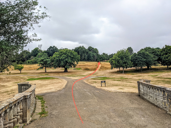 |
| Continue on Hatfield footpath 59 (see orange arrow) |
Continue on Hatfield footpath 59 for 580m until you reach Marford Road, the B653 (location -
https://w3w.co/tonic.drums.hidden). On your left will be
The Crooked Chimney (location -
https://w3w.co/plant.wounds.spicy).
 |
| Cross Marford Road then head W along Cromer Hyde Lane |
3: Cross Marford Road then head W along Cromer Hyde Lane for 910m until you reach a junction of footpaths and tracks (location -
https://w3w.co/porch.nurse.manliness), see image below.
 |
| Turn right on Hatfield footpath 54 |
4: Turn right on Hatfield footpath 54 then follow it NW for 100m until you reach a gate leading to a livestock field (location -
https://w3w.co/powers.parks.files), see image below. When we did this walk we didn't see any livestock.
 |
| Cross the field aiming for the right of the stables |
Cross the field aiming to the right of the stables (see orange arrow on image above). Continue heading in a northwesterly direction, still on Hatfield footpath 54, for 520m until you reach a junction beyond a gap in the hedgerow (location -
https://w3w.co/prefer.clots.dusty), see image with orange arrow below.
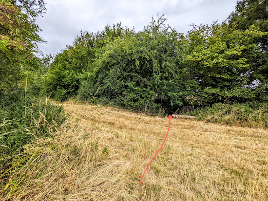 |
| Hatfield footpath 54 cuts through the hedgerow to reach a junction |
5: At the junction turn left on Wheathampstead BOAT 3 (
byway open to all traffic) for 30m until you reach a footpath on the right (location -
https://w3w.co/trip.total.nails), see image below.
 |
| Turn right on Wheathampstead footpath 76 |
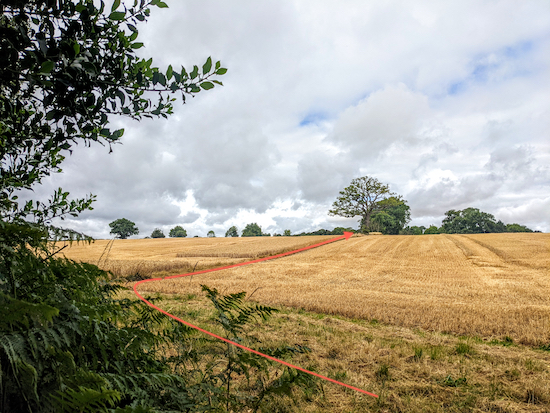
Turn right on Wheathampstead footpath 76 then continue heading NW for 100m with fields on either side of the path until you reach a line of trees (location -
https://w3w.co/caves.ground.flops), see image of route between the fields to the line of trees below.
 |
| Follow Wheathampstead footpath 76 to Coleman Green Lane |
Keep left at the line of trees (see image below) and continue heading NW for 210m until you reach Coleman Green Lane, a former Roman road (location -
https://w3w.co/solar.wiring.arts).
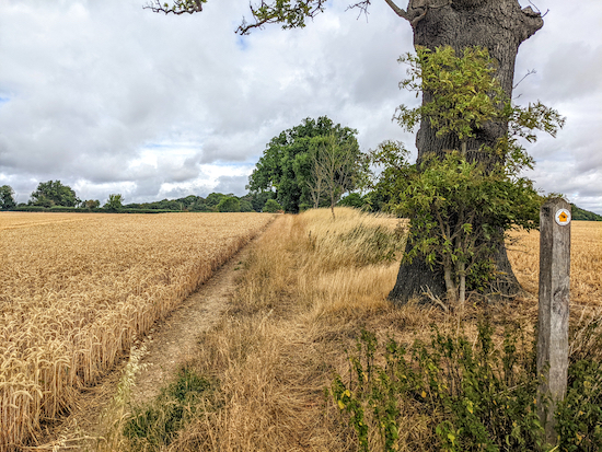 |
| Keep to the left of a line of trees on Wheathampstead footpath 76 |
6: Turn right on Coleman Green Lane then head NE for 400m until you reach Marford Road (location -
https://w3w.co/sound.cake.fund).
* This section of Coleman Green Lane is narrow and there is no pavement for pedestrians. We didn't meet any traffic when we tested this walk.
7: Cross Marford Road then turn right and head E for 70m until you reach Waterend Lane on the left (location -
https://w3w.co/juror.volunteered.salon).
 |
| Take the permissive bridleway alongside Waterend Lane |
Turn left at the top of Waterend Lane then take the permissive bridleway immediately on your right (location -
https://w3w.co/wash.improving.device), see image below.
 |
| Take the permissive bridleway at the top of Waterend Lane |
Follow this permissive bridleway NE for 475m until it rejoins Waterend Lane at a ford and a footbridge (location -
https://w3w.co/shaky.pigs.tender).
8: Turn right on Waterend Lane, cross the footbridge (or the ford) then take the footpath immediately on the right (location -
https://w3w.co/think.bound.wheels), see image below.
 |
| Take the footpath immediately on the right after the bridge |
Follow this path, Wheathampstead footpath 13 as it weaves SE alongside the River Lea on your right for 580m until you reach a junction (location -
https://w3w.co/agreed.sunset.horses), see image below.
 |
| After the junction climb a steep hill through woodland |
9: Ignore the right turn at the junction and continue heading SE and uphill, still on Wheathampstead footpath 13, for 30m until you cross the parish boundary and the path you are on becomes Hatfield footpath 57.
Continue for 220m until the path leaves woodland then crosses a golf course (location -
https://w3w.co/loser.paints.mild).
I have added some orange arrows on the map below to indicate which way to look for golfers hitting balls across the public right of way, however the direction of flight might change, so look both ways to be sure.
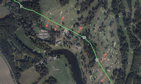 |
Keep looking right and left when crossing the fairways
Satellite image sources: Esri, DigitalGlobe, GeoEye, Earthstar Geographics,
CNES/Airbus DS, USDA, USGS, AEX, Getmapping, Aerogrid, IGN,
IGP, swisstopo, and the GIS User Community |
Continue heading SE, still on Hatfield footpath 57, for 510m until you reach a track (location -
https://w3w.co/freed.shade.quest), see image below.
 |
| Cross the track then head SSE, still on Hatfield footpath 57 |
10: Turn right to cross the track (see the line of the orange arrow on the image above) then head SSE, still on Hatfield footpath 57, for 270m until you reach a junction (location -
https://w3w.co/scarcely.rocky.film), see image below.
 |
| Continue on Hatfield footpath 57 crossing a fairway |
11: Continue on Hatfield footpath 57 for 350m crossing a fairway (again please check for golfers and flying golf balls) and heading to the right of some tall trees, see image below.
 |
| Cross a fairway and head to the right of some tall trees |
11: Continue heading SSE, still on Hatfield footpath 57 for 90m until the path splits (location -
https://w3w.co/value.occupy.living), see image below.
 |
| Take the left fork then follow Hatfield footpath 57 back to the start |
Take the left fork then follow the path, still Hatfield footpath 57, SE for 115m until you reach the junction you passed at point 2 in the walk. Follow Hatfield footpath 57 SE for another 75m back to the starting point.
Interactive map


Really enjoyed this walk yesterday (10th September) with my wife and 8 month old (in a back carrier). We downloaded the GPS route and also found the instructions and photos on this page extremely useful - thank you!
ReplyDeleteThe grounds around Brocket Hall were picturesque and there were also lovely views on the more rural sections.
We didn't encounter any livestock at the part of the walk that they are mentioned either thankfully.
For anyone that is planning to drive - we parked at The Sun Inn who have a good size car park and were fine with us doing the walk before stopping there for lunch. Lots of seating both indoor and outdoor, friendly staff and the food was great.
Thanks Simon, good to know The Sun Inn is okay about parking if people are eating after the walk. Glad you enjoyed it.
DeleteHi another nice walk . Thank You . I took up Simons advice and Parked inThe Suns car park , staff were really good about it. I did make a detour at point 6 turned left for a pint at The John Bunyan 🤣😂. At point 7 I would suggest walking down Waterend Lane as Bridal Path is very overgrown and unless you wearing waterproof trousers your going to get wet. .IR.
ReplyDeleteHi Ian, thanks for those tips. Very helpful. David
DeleteProbably the best walking instructions I’ve ever used, thank you
ReplyDeleteWow, thanks for the feedback. So glad the instruction helped, and I hope you enjoyed the walk --- and many more to come. Thanks for taking the time to write. David
Delete