5.8 miles (9.4km) with 83m of total ascent
 |
| The view towards Gilston Park |
This route includes a couple of paths that feature in
Walk 105: Hunsdon East Loop but followed in reverse, offering different views. The walk circles the
Hunsdon Airfield, used by the RAF between 1941 and 1945 under the name of RAF Hunsdon. The route heads SE to visit the village of Eastwick at the halfway point.
Getting there
There are bus stops close to The Crown pub in Hunsdon (location -
https://w3w.co/matter.pushy.insist), which are served by the number 35 and 35c buses. You can check bus times at
Intalink.
Fly through preview of walk
If you want to check what sort of landscape you will be crossing before you set off on this walk you can view a short 3D video of the route below. It's created using the free version of
Relive.
Directions
 |
Walk 177: Hunsdon South East Loop
Click here or on the map for larger version
Created on Map Hub by Hertfordshire Walker
Elements © Thunderforest © OpenStreetMap contributors
There is an interactive map below the directions |
Those with GPS devices can download
GPX or
KML files for this walk. We've added
What3Words location references for those who use that navigation system. If you print these walks you might want to use the green
PrintFriendly icon at the bottom of these directions to delete elements you don't need.
Many of the paths on this walk cross fields which, when we mapped and tested the route in May 2022 were clearly defined but which might not be as obvious after the fields are ploughed. So we suggest that those who have smartphones download the
GPX or
KML files for the walk, then download either the free
Komoot app or the free GPX Viewer app on
Android or
Apple. You can then open the files in one of those viewers. They will then act in a same way that a sat nav does in a car and will make sure are going the right way.
Below is a satellite image of the section, at the start of the walk, where the public rights of ways go over arable land.
 |
Satellite image of points 3 to 6 across arable land
Source: Esri, DigitalGlobe, GeoEye, Earthstar Geographics,
CNES/Airbus DS, USDA, USGS, AEX, Getmapping, Aerogrid,
IGN, IGP, swisstopo, and the GIS User Community |
There is also a 130m section of footpath at point 12 where, in early May, nettles were starting to encroach the right of way, so we suggests wearing long trousers or that you pick up a stick to push the nettles aside.
1: With your back to The Crown (location -
https://w3w.co/herbs.update.having) turn right then head NE for 30m until you reach Drury Lane on the right (location -
https://w3w.co/bats.judge.energy). Turn right on Drury Lane then head NE for 200m until you reach the end of the lane and a
footpath just to the right of a road sign which reads Amiens Close (location -
https://w3w.co/lasted.bank.volume), see image below.
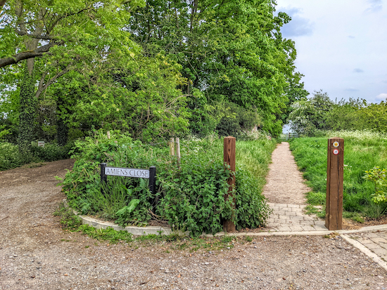 |
| Take the path on the right then head ESE for 50m to a metal gate |
2: Take this path, Hunsdon footpath 10, then head ESE for 50m to a metal gate.
 |
| The WWII pillbox to the left of Hunsdon footpath 10 |
As you walk this stretch look out for the
WWII pillbox on your left (location -
https://w3w.co/dive.ahead.pilots).
 |
| The metal gate just beyond the WWII pillbox |
After passing the pillbox continue through the gate then head straight and ESE for 65m until you reach a track (location -
https://w3w.co/just.safe.dress).
 |
| Cross the track then head SE on Hunsdon footpath 10 |
3: Cross the track then continue, still on Hunsdon footpath 10, but now heading SE for 330m until you reach a footpath junction at a marker post (location -
https://w3w.co/grab.slice.winks).
 |
| Keep to the left, still on Hunsdon footpath 10, now heading ESE |
4: Keep to the left at the junction, still on Hunsdon footpath 10, but now heading ESE for 310m until you reach a track (location -
https://w3w.co/sheep.fluid.look).
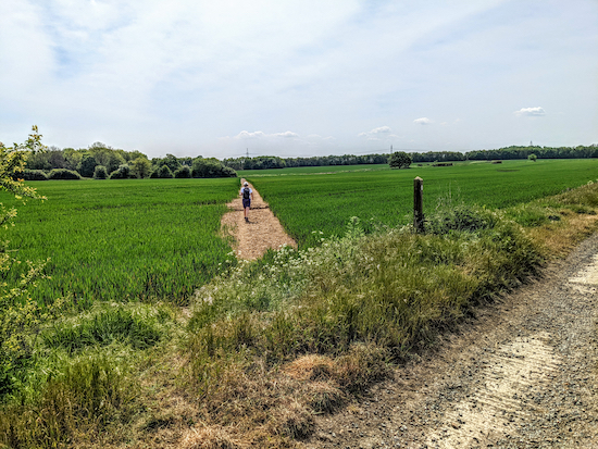 |
| Hunsdon footpath 11 bends to the left then heads SSE |
5: Cross the track then head SSW on Hunsdon footpath 11 for 200m to a junction (location -
https://w3w.co/rocks.moons.rock). Hunsdon footpath 11 bends to the left then heads SSE for 65m until it reaches a track (location -
https://w3w.co/copy.valve.relax).
 |
| Hunsdon footpath 11 heading SE towards Tuck's Spring |
6: Cross the track then head SE on Hunsdon footpath 11 until, after 60m, you reach woodland on the left called Tuck's Spring (location -
https://w3w.co/hopes.scarf.local) at which point the path you are on becomes Eastwick & Gilston footpath 7.
 |
| Eastwick & Gilston footpath 7 heading through the gap mentioned below |
Continue heading SE alongside the woodland for 100m until the footpath bends to the left (location -
https://w3w.co/liner.dark.town) and goes through a gap (see image above). Eastwick & Gilston footpath 7 then bends right (location -
https://w3w.co/haven.post.doing) then heads S for 170m across a field before reaching woodland (location -
https://w3w.co/chops.pits.dock).
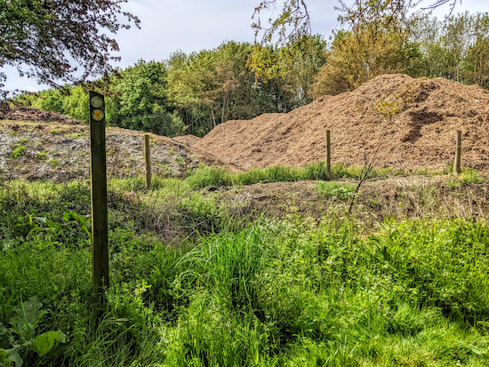 |
| Turn right on the permissive path, see point 7 below |
7: Continue heading S through the woodland, still on Eastwick & Gilston footpath 7, for 30m until the path bends to the right (location -
https://w3w.co/burn.finest.sizes). At this point, Eastwick & Gilston footpath 7 would have continued heading S though a farm, but that way is now blocked. Instead, a permissive path has been created that turns right and heads W for 45m before bending left and heading S for 160m to reach a track.
 |
| Turn right, now on Eastwick & Gilston footpath 8, and head W |
8: Cross a stile, turn right, now on Eastwick & Gilston footpath 8, and head W for 200m looking for a track on the left (location -
https://w3w.co/format.stage.joined).
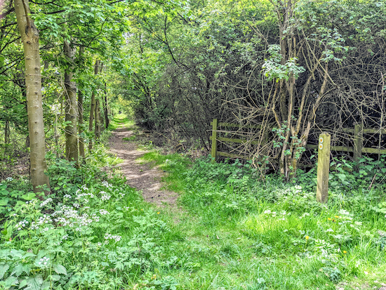 |
| Eastwick & Gilston footpath 9 heading S |
9: Take this track, Eastwick & Gilston footpath 9, then head S for 610m until you go through a gap in the hedge (location -
https://w3w.co/shares.arch.editor).
 |
| The route in red avoids trampling the crop |
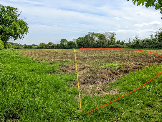
10: At this point, Eastwick & Gilston footpath 9 goes diagonally across a field (see yellow arrow on photograph above), but the farmer had recently sown seed and the path had not been reinstated, so, rather than trample the plants, we went round the edge of the field (see red arrow on photograph above) where we met the path on the other side of the field (location -
https://w3w.co/jungle.mining.flame).
 |
| Go through a gap in the hedge then head then SSE |
11: Go through a gap in the hedge then head SSE, still on Eastwick & Gilston footpath 9, for 850m until you reach Eastwick Hall Lane in the village of Eastwick (location -
https://w3w.co/menu.wake.leaps).
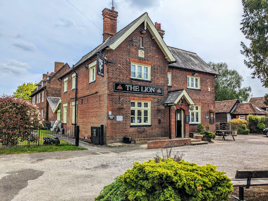 |
| The Lion in Eastwick "open all day every day" |
At this point you could visit
The Lion for refreshments (location -
https://w3w.co/lines.points.hero). A sign on the wall reads
"open all day every day".
 |
| Take Eastwick & Gilston footpath 16 then head NE |
12: Turn left on Eastwick Hall Lane then head N for 150m looking out for a footpath on the right (location -
https://w3w.co/total.rescue.spring). Take this path, Eastwick & Gilston footpath 16 then head NE for 130m through woodland. When we tested this route in early May 2022 this section was becoming overgrown with nettles, so we recommend you wear long trousers or pick up a stick in order to push the nettles back.
 |
| Head NE and uphill across a field on Eastwick & Gilston footpath 16 |
Once through that section you head NE and uphill across a field for 610m to a junction (location -
https://w3w.co/perky.fend.grass).
 |
| Gilston Park as seen from Eastwick & Gilston footpath 20 |
13: Turn left at the junction on Eastwick & Gilston footpath 20 then follow it NNE then NE for 960m to a junction (location -
https://w3w.co/backup.organ.logo), passing
Gilston Park, a
Grade II listed building, on the right.
One website we researched states that there are
plans to build 10,000 homes on the site. Another mentioned
8,500 homes "set out in six villages", so probably best to make the most of this lovely countryside before it's too late.
 |
| At the junction turn left on Eastwick & Gilston footpath 28 |
14: At the junction turn left on Eastwick & Gilston footpath 28 then head N for 210m until you reach a lane (location -
https://w3w.co/launch.dish.noble).
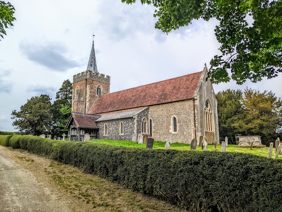 |
| St Mary's Church, Gilston, a Grade II listed building |
15: Turn left on the lane then head NW for 160m passing St Mary's Church,
a Grade II listed building dating back to the 13th century, on the right (location -
https://w3w.co/loaf.taking.dices) and then taking the first track on the right immediately after the church (location -
https://w3w.co/among.critic.speak).
This is Eastwick & Gilston
restricted byway 24 which heads then head N for 920m at which point the track becomes High Wych restricted byway 38 and continues heading N for another 100m to reach a junction (location -
https://w3w.co/random.task.dozed).
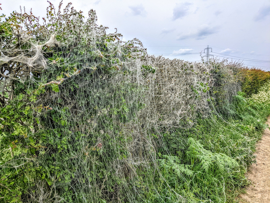 |
| The caterpillar cobwebs alongside restricted byway 24 |
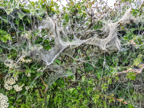 |
| The caterpillar cobwebs alongside restricted byway 24 |
As we walked this stretch in May we noticed cobwebs draped over the hedgerow (location -
https://w3w.co/pots.bake.thing). We shared the image on the
Hertfordshire Walker Facebook page to try to find out more about them. Some suggested they were caused by '
tent caterpillars' and could be
ermine moths.
 |
| Turn left on High Wych footpath 22 keeping left of the pylon |
16: Turn left at the junction on High Wych footpath 22 then head W for 430m at which point (location -
https://w3w.co/limit.staple.forget) the footpath you are on becomes Eastwick & Gilston footpath 1.
 |
| Keep heading straight and W, now on Eastwick & Gilston footpath 4 |
Continue, now heading WSW for 320m, to a junction (location -
https://w3w.co/places.jumps.names), see image above. Keep heading straight and W, now on Eastwick & Gilston footpath 4, for 240m until you reach
Hunston Airfield (location -
https://w3w.co/socket.short.shady). According to the village website:
"Sorties from the RAF Hunsdon provided a major contribution to the night time defence of Britain and, once the threat of attack to London had diminished, the primary role turned from defence to attack. The De Havilland Mosquito became the mainstay of its fighter bomber role and contributed to many significant attacks during the later stages of the war."
 |
| Hunsdon Airfield |
17: Continue heading W on Eastwick & Gilston footpath 4 with the woodland on your right and a line of green metal buildings on your left until you emerge alongside the airfield car park (location -
https://w3w.co/option.fallen.pure).
 |
| WWII pillbox on the edge of Hunsdon Airfield |
Pass the car park on your left then head NW, now on Hunsdon footpath 17, with the woodland on your right, continuing for 170m until you reach a junction on the edge of the woodland (location -
https://w3w.co/slices.once.shorts). Behind the hedgerow and in the woodland at this point are the remains of another WWII pillbox (location -
https://w3w.co/much.known.trash), see image above and the red marker on satellite image below.
 |
Head W after point 18 for 90m then SW
Source: Esri, DigitalGlobe, GeoEye, Earthstar Geographics,
CNES/Airbus DS, USDA, USGS, AEX, Getmapping, Aerogrid,
IGN, IGP, swisstopo, and the GIS User Community |
18: Go straight across the junction and continue heading W still on Hunsdon footpath 17, for 90m until the footpath bends left (location -
https://w3w.co/retail.tender.went), see satellite image above.
Keep left at the junction then head SW for 610m before reaching Drury Lane close to point 2 in the directions. Head SW along Drury Lane for 200m back to the village of Hunsdon and the starting point.
There are two pubs in Hunsdon.
The Crown (location -
https://w3w.co/images.pump.lance) and
The Fox & Hounds (location -
https://w3w.co/shift.fire.ashes). There is also a village store (location -
https://w3w.co/career.memory.trees)
Interactive map


Did this walk today in the beautiful sunshine. Quite a few of the paths were quite overgrown (my husband always wears shorts and had to find a few dock leaves to soothe the nettle stings on his legs!) The stile along footpath 8 was so overgrown and hardly visible so we had to climb up the bank to the left instead. Had a drink in the peaceful pub garden at the Lion which made a welcome half way sit down. We've never seen those caterpillar cobwebs before and wondered what they were til we read your comments. We didnt see anyone (apart from the barlady at the pub) on the entire walk. Dont know where everyone was but it was such a peaceful walk and we'd do it again but take your advice to use a stick to push back the nettles. Thanks again for all these free walks.
ReplyDeleteYes, the nettles seem far bigger and more aggressive this year. Sorry to hear your husband got stung. I hope it didn't spoil his day.
DeleteHi Dave and Ellie walked Route 177 today the point you mentioned at 12 is fine a 6 foot wide path has been cut through it 👍 at point 7 the track is so over grown it was easier to walk on river bed as it dried up . Long slog pass church to point 16 but the sun was out . At t the airfield chatted to chap who was about to fly . Then Two Red Kites came over and played for five mins . So all good thanks again. IR.
ReplyDeleteHi Ian, thanks for the feedback. It's great when walkers like you share updates for the benefit of everyone. Thanks for doing this. I am afraid that this is the time of the year when paths do become overgrown, but good to know that some get cleared, and that people like you report back. Have you used the HCC ROW link to report the other overgrown section? Thanks, Dave (and Ellie)
DeleteHi Dave no I haven’t yet but will do .
ReplyDeleteThis walk is for wheat lovers. It is field upon field upon field of wheat stretching as far as the eye can see in every direction. To be really honest, I think this walk in the winter would be very flat and dull. Like others, we found several parts of the walk almost impenetrable with nettles and brambles. Our lunch at the Fox&Hounds was superb (and pricey). I think Mr Brewer does an absolutely fabulous job but this walk is not as good as most :-)
ReplyDeleteHester
Thanks for the feedback, Hester. Sorry you didn't enjoy the walk as much as others you have tried. David
DeleteI came prepared with long trousers and a pruning saw. Cut down many oak and blackthorn branches and whacked away many nettles and brambles. Still some parts were impenetrable and I had to take detours. The best part of the walk were the rare birds that I saw; Grey Partridge, Yellow Wagtail and Hobby.
ReplyDeleteHi Mark, well done spotting a Hobby. Sad about the overgrown paths. A real problem this time of the year. We are on a walk now and having to deal with brambles and nettles. All part of the challenge. :-)
DeleteUpdate 16/08/2024. The permissive path from point 7 is difficult to negotiate as it is a mass of brambles and nettles. Also, the Lion pub in Eastwick is closed, potentially being redeveloped by McMullens but with no timings.
ReplyDeleteThanks for the feedback and the information on The Lion. It seems McMullen Brewer is looking for tenants for a number of pubs, that one includes.
Deletehttps://www.mcmullens.co.uk/tenancy-pub/the-lion/