4.9 miles (7.8km) with 80m of total ascent
.jpg) |
| The byway between points 18 and 19 |
This is a lovely quiet walk well away from the noise of major roads. It's ideal for those who want to get away from it all and enjoy listening to birdsong and the wind in the trees. The walk starts in the
village of Sandon then passes
Blagrove Common, a site of
special scientific interest which is managed by the
Herts and Middlesex Wildlife Trust. Unusually for our walks this route doesn't pass a pub, but we have added the nearest on the map along with details at the foot of these directions.
This route was modified after Gerry Gross, a member of our
Hertfordshire Walker Facebook group, reported that parts of the walk were waterlogged and various gates had been changed along the way. We are always grateful to followers of Hertfordshire Walker who contact us when routes have been diverted or changed. We revisited the walk on 20 January 2023 and have since made significant changes to the route, particularly the start. If you have walked this route before you might want to try it again.
Fly through preview of walk
If you want to check what sort of landscape you will be crossing before you set off on this walk you can view a short 3D video of the route below. It's created using the free version of
Relive.
Directions
 |
Map for Walk 171: Sandon East Loop
Click the map for larger version
Created on Map Hub by Hertfordshire Walker
Elements © Thunderforest © OpenStreetMap contributors
There is an interactive map below these directions |
Those with GPS devices can download
GPX or
KML files for this walk. We've added
What3Words location references for those who use that system. If you print these walks you might want to use the green
PrintFriendly icon at the bottom of these directions to delete elements such as photographs.
 |
| Church of All Saints Sandon at the start and finish of the walk |
1: With your back to the
Church of All Saints in Sandon (location -
https://w3w.co/abstracts.dull.harp), turn left then head S along Deadman's Hill for 45m to a junction (location -
https://w3w.co/toasters.sulky.intervals), see image below.
 |
| Keep left at the junction then head SSE |
2: Keep left at the junction then head SSE along a road for 55m until you reach a
footpath on the right (location -
https://w3w.co/quest.equal.scatters), see image below.
 |
| Turn right on Sandon footpath 9 |
3: Turn right on Sandon footpath 9 then head S ignoring a permissive bridleway on the left. Continue heading S on Sandon footpath 9 for 80m until you pass a gate (location -
https://w3w.co/salads.shorthand.motivations), see image below.
 |
| Continue on Sandon footpath 9 |
4: Continue on Sandon footpath 9 and still heading S for 155m until you reach another gate and a footbridge (location -
https://w3w.co/straying.evaporate.crucially), see image below.
 |
| Go through the gate then cross a footbridge |
5: Go through the gate then cross a footbridge. Once over the footbridge go through a gate leading to the
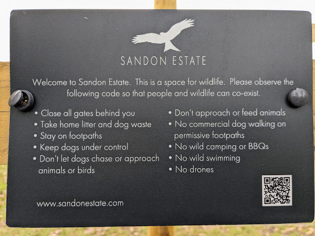
Sandon Estate. The estate has made 1,000 acres available to create "a wilder space for nature". The following text, which is taken from the estate's website, describes the purpose of the project.
"Working with Natural England, The Environment Agency and the Forestry Commission to make a space for nature. Creating a more natural landscape of wood pasture where a mixture of scrub, woodland and pasture will flourish. Managing grazing and browsing pressure to create a kaleidoscope of habitats – ideal homes for birds, bees, butterflies and insects."
 |
| The sign on the entrance to the Sandon estate |
Once through the gate turn left then head SE on Sandon footpath 7 for 500m, with the fence on your left and field on your right, ignoring paths on your left until Sandon footpath 7 bends right (location -
https://w3w.co/drain.laminated.udder).
Continue, now heading WSW, for 55m until Sandon footpath 7 turns left at a gate (location -
https://w3w.co/ledge.daisy.merely), see image below.
 |
| The gate where Sandon footpath 7 enters and crosses Blagrove Common |
6: At this point you leave Sandon footpath 7 which turns left then crosses
Blagrove Common via a footbridge. You continue heading WSW with the fence on the left but now on Sandon footpath 10.
The common is managed by The Herts and Middlesex Wildlife Trust, which describes it as "one of the finest areas of marshy grassland in Hertfordshire where orchids abound". Our original route used to cross the common, but the area is boggy most of the year so the new route skirts the common. When we have walked that way in the past we have come across some lovely flora, including Marsh Marigold, pictured below.
 |
| Marsh Marigold on Blagrove Common |
Having ignored the path into Blagrove Commons, continue heading WSW, now on Sandon footpath 10. Continue with the fence on the left and field on the right for 140m until you reach a junction (location -
https://w3w.co/torn.dusts.cabbies), see image below.
 |
| Continue heading WSW, now on Sandon footpath 11A |
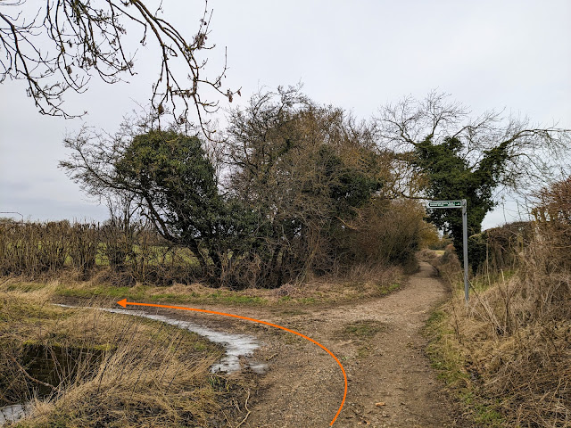
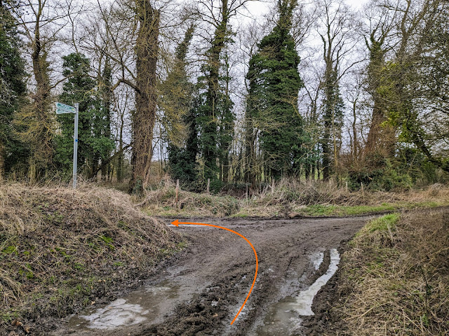
7: At this point you will see another entrance to Blagrove Common on the left. Ignore it and continue heading WSW, now on Sandon footpath 11A, for 10m until the path bends left with the fence (see orange arrow on the image above). Follow Sandon footpath 11A left as it heads S for 35m to another gate (location -
https://w3w.co/hence.power.digesting), see image below.
.jpeg) |
| Continue heading S on Sandon footpath 11A |
Go through the gate then pass another entrance to Blagrove Common on the left. Continue heading S and slightly uphill, still on Sandon footpath 11A, see image below.
.jpeg) |
| Continue heading S, still on Sandon footpath 11A |
Continue heading S on Sandon footpath 11A for 290m until you reach at Beckfield Lane (location -
https://w3w.co/sparkle.schooling.defender), see image below.
 |
| Turn left on Beckfield Lane then head ENE |
8: Turn left on Beckfield Lane then head ENE for 420m ignoring the first footpath on the left (which is Sandon footpath 7 and which also leads to Blagrove Common) and continuing to the second footpath on the left just beyond a thatched cottage (location -
https://w3w.co/character.diverts.thunder), see image below.
 |
| Turn left after the thatched cottage on Sandon footpath 8A |
9: Turn left after the thatched cottage on Sandon footpath 8A. Head NW for 65m with cottages on your left, see image below.
 |
| Continue past the cottages until you reach a gate |
Continue past the cottages until you reach a gate which leads (you guessed it) into Blagrove Common (location -
https://w3w.co/commoners.think.flat), see image below.
 |
| Go through the gate then cross an elevated walkway |
Go through the gate then walk W for 10m along an elevated walkway to another gate (location -
https://w3w.co/admits.matchbox.reclaimed), see image below.
 |
| Go through the gate then head NW on Sandon footpath 8A |
Go through the gate then head NW on Sandon footpath 8A for 25m heading for a marker post (see orange arrow on the photograph above).
If this section is too boggy you can avoid the worst by walk along higher ground to the marker post in order to avoid the wet patches.
 |
| Take the right fork then follow Sandon footpath 32 |
Once you reach the marker post take the right fork then follow Sandon footpath 32 NW, with the hedgerow on the right and the common on the left, for 60m until you reach a gate on the right leading to a footbridge (location -
https://w3w.co/variation.blacked.received), see image below.
 |
| Turn right through the gate on Sandon footpath 32 |
10: Turn right through the gate, cross the footbridge, then head NE on Sandon footpath 32, passing Tichney Wood on the left and continuing for 220m until you reach a gate leading to a field (location -
https://w3w.co/shut.seaside.charities), see image below.
 |
| Cross an arable field on Sandon footpath 17 |
11: Once through the gate head NE across an arable field on Sandon footpath 17 for 170m until you reach a lane (location -
https://w3w.co/gripes.vitals.plankton).
12: Turn left on the lane then head N for 120m until you reach a junction (location -
https://w3w.co/sprains.feel.painters), see image below.
 |
| Turn right at the junction |
13: Turn right at the junction then head ESE for 140m ignoring a track on the left and continuing until you reach a right-hand bend and a byway on the left (location -
https://w3w.co/lyricist.dressy.straw), see image below.
 |
| Turn left on Sandon BOAT 45 |
14: Turn left on Sandon BOAT 45 (
byway open to all traffic) then head N then NNE along a lovely track for 830m until you reach a junction (location -
https://w3w.co/disengage.questions.disposing) see image below.
 |
| Turn right on Therfield BOAT 41 |
15: Turn right at the junction, now on Therfield BOAT 41, then head ENE. After 510m you will pass
Hawkins Wood on the right. According to
Herts and Middlesex Wildlife Trust Hawkins Wood is "an ancient woodland which provides good opportunities to see bluebells in the spring". The nature reserve was closed at the time we did the walk because of
Ash dieback disease.
 |
| The entrance to Hawkins Wood |
Continue for 490m until you reach a T-junction (location -
https://w3w.co/recently.sticky.overpaid), see image below.
 |
| Turn left at the T-junction on Therfield BOAT 36 |
16: Turn left at the T-junction on Therfield BOAT 36 then head NNW for 730m until you reach a byway on the left (location -
https://w3w.co/rust.posed.prowling), see image below.
 |
| Turn left on Kelshall UCR1 |
17: Turn left on Kelshall UCR1 (
unclassified unmetalled county road) then head WSW for 115m then NW for 315m until you reach a junction (location -
https://w3w.co/inflates.round.soldiers), see image below.
 |
| Turn left on Kelshall UCR2 |
18: Turn left at the junction then follow Kelshall UCR2 SW.
This section can be muddy after rain. After 645m Kelshall UCR2 becomes Kelshall BOAT 18 then continues heading SW then W for 450m until it reaches a lane (location -
https://w3w.co/married.wired.abacus), see image below.
 |
| Turn left on the lane then head S |
19: Turn left on the lane then head S for 515m until you reach a right-hand bend (location -
https://w3w.co/arrival.waistcoat.casino), see image below.
 |
| Follow the lane round to the right |
20: Follow the lane round to the right then head SW for 200m looking out for a footpath on the left (location -
https://w3w.co/spinning.feast.bolsters), see image below.
 |
| Turn left on Sandon footpath 36 |
21: Turn left on Sandon footpath 36 then follow it SW for 350m back to Sandon Church (location -
https://w3w.co/windows.pumps.strikers). Follow the footpath through the churchyard and back to the starting point.
 |
| Church of All Saints, Sandon |
Unusually for our walks this route doesn't pass a pub. The nearest to the start and finish point is
The Fox & Duck in Therfield.
Interactive map
.jpg)


.jpeg)
.jpeg)


Thank You
ReplyDeleteA very enjoyable Sat morning
Still abit boggy around 4 but managable
Great way for me to get back outside again
Kevan
Glad you enjoyed it. Yes, it's a bit boggy there. The detour does avoid the worst part. Thanks for the feedback.
DeleteDavid
Hi could you please tell me how do I join?
ReplyDeleteHi, no need to join, in fact there is nothing to join. Just download the walks either to print off or to follow on a smartphone. They are all free to enjoy. You don't need a paid-for app and you don't need a subscription. We have kept it simple. Let me know if you need any help.
DeleteDavid
Hi Dave and Ellie another great walk open fields , wooded paths and lanes great to have some shade on a sunny day like today . The bogey part at point now all dried out ( grass very long but you can see the far side of field) . At point 7 Farmer has reinstated footpath 👏🏻👏🏻👏🏻, and the Ford at point 11 Totally dried up but guess to be expected this time of year. Thanks again . IR.
ReplyDelete