5.7 miles (9.2 km) with 80m of total ascent
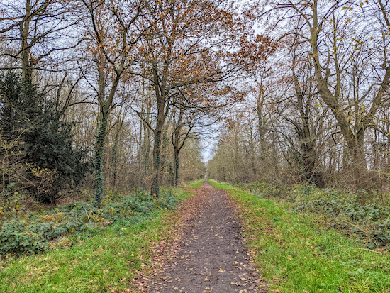 |
| The path along Morgan's Walk between points 10 & 11 |
This walk starts and finishes at
The Goat pub/restaurant in the village of Hertford Heath, where we had an excellent meal and pint at the end of our walk. The route then loops past the
Fox Holes Farm shop before edging round the southern outskirts of Hertford then heading south passing three
Herts & Middlesex Trust Wildlife Trust nature reserves. It then returns to Hertford Heath passing
The College Arms, where we also had a lovely meal and pint
on a previous walk. There is a third pub in Hertford Heath,
The Silver Fox, which we haven't tried.
We tested this walk on 14 December 2021 and parts, particularly the section between points 12 & 13, were waterlogged. The field was sodden and there were deep puddles at two gates (see image below at point 12). So if you want to do this walk we suggest you take wellies or wait until the dry weather.
Getting there
There are bus stops on London Road close to the junction with Church Hill (location -
https://w3w.co/juror.votes.zebra). The stops are 250m SW of the start of the walk. They are served by the numbers 341 and 641. You can check bus times at
Intalink.
Fly through preview of walk
If you want to check what sort of landscape you will be crossing before you set off on this walk you can view a short 3D video of the route below. It's created using the free version of
Relive.
Directions
 |
Map for Walk 167: Hertford Heath West Loop
Click on the map for a larger version
Created on Map Hub by Hertfordshire Walker
Elements © Thunderforest © OpenStreetMap contributors
There is an interactive map below these directions |
Those with GPS devices can download
GPX or
KML files for this walk. We've added
What3Words location references for those who use that system. If you print these walks you might want to use the green
PrintFriendly icon at the bottom of these directions to delete elements such as photographs.
 |
| The Goat at the start/finish point |
1: With your back to The Goat pub/restaurant in Hertford Heath (location -
https://w3w.co/steep.dishes.liner) turn right then head W down Vicarage Causeway for 260m until you reach London Road (location -
https://w3w.co/gossip.amount.bands).
 |
| Hertford Heath footpath 6 after point 2 |
2: Turn right on London Road then head NW for 20m looking out for a footpath on the right. Take this footpath, Hertford Heath footpath 6, (which was muddy when we tested this walk in December 2021) then head NNW for 440m, with the hedgerow on the right and the field on the left and continue until you reach a track (location -
https://w3w.co/doctor.woven.cliff), see image below.
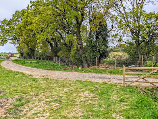 |
| When the footpath reaches a track, turn left on Hertford footpath 44 |
3: When you reach the track, turn left on Hertford footpath 44 then head NW for 270m, with the trees on your right and the field on your left. You will pass a garden nursery on the left (location -
https://w3w.co/school.truth.keep) and some parked trucks and farm buildings before reaching Fox Holes Farm, where you will find several craft shops and the Fox Holes Farm shop on the right (location -
https://w3w.co/burn.adjust.crass).
4: Follow the track out of Fox Holes Farm as it heads W then SSW for 440m before reaching London Road (location -
https://w3w.co/unfair.taxi.cheese).
 |
| Take the bridleway on the left off London Road - point 5 |
5: Turn right and cross London Road then follow the footpath alongside the road NW for 230m until you reach a bridleway on the left (location -
https://w3w.co/given.final.body).
 |
| The bridleway mentioned in point 6 |
6: Go through the gate and head SW on Hertford bridleway 113 for 30m then follow the bridleway as it bends to the right and heads W for 400m to a junction (location -
https://w3w.co/cool.churn.breed).
You are now in Balls Park, which,
according to Wikipedia is:
"... a Grade I Listed mid-17th-century house. The estate and house are set in over 63 acres of parkland which is listed Grade II on the English Heritage Register of Parks and Gardens of Special Historic Interest. The estate and house has been claimed to have been the inspiration for some of Jane Austen's novel Pride and Prejudice"
Turn right at the junction then head N for 30m looking for a bridleway on the left (location -
https://w3w.co/spring.metals.never), see image above.
7: Head SW for 270m on Hertford bridleway 112 until you reach a junction (location -
https://w3w.co/master.rides.being).
 |
| Hertford bridleway 112 heading WNW to Mangrove Road |
8: Turn right, still on Hertford bridleway 112, then head WNW for 280m until you reach Mangrove Road (location -
https://w3w.co/chat.hobby.excuse).
 |
| Hertford footpath 78 off Mangrove Road |
9: Cross Mangrove Road then take Hertford footpath 78 and follow it WSW downhill and then SW uphill for 380m until you meet Queen's Road (location -
https://w3w.co/patio.army.judge).
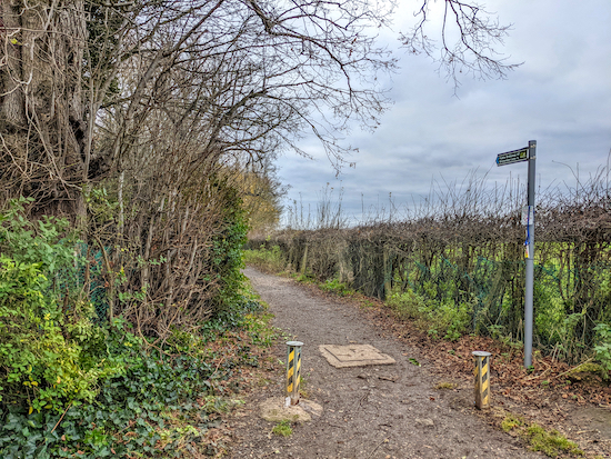 |
| Morgan's Walk, Hertford bridleway 47, heading SSE |
10: Turn left on Queen's Road then head SSW for 420m until you reach a bend in the road (location -
https://w3w.co/solid.judges.exist) at which point Queen's Road is also Hertford footpath 50. Continue until you reach a track on the left, Hertford bridleway 47, also known as Morgan's Walk (location -
https://w3w.co/frogs.earth.dance).
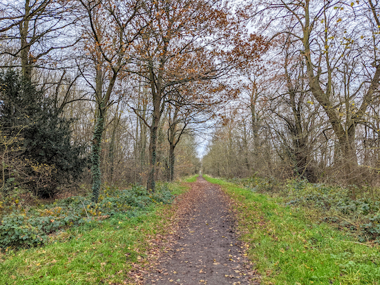 |
| Morgan's Walk heading SSE |
11: Turn left on Morgan's Walk, which is also Hertford bridleway 47, then head SSE for 540m until you reach a footpath on the left (location -
https://w3w.co/models.brain.hotel).
 |
| One of the waterlogged gates between points 12 & 13 |
12: Turn left and follow Hertford footpath 48 for 370m crossing fields and passing through several gates, continuing until you reach a gate on the right and a junction (location -
https://w3w.co/flat.outfit.nurses).
* This section was waterlogged when we did this walk in December 2021, so waterproof boots, preferably wellies, would be best in the winter. However Ian Roberts did the walk in April 2020 and kindly sent this picture of the same gate saying it wasn't waterlogged when he walked it.
 |
The same gate between points 12 & 13 taken in April 2022
Image courtesy of Ian Roberts |
 |
| Turn right on Brickendon Liberty footpath 11 - point 13 |
13: At the junction turn right, now on Brickendon Liberty footpath 11, then follow it SSE then SE for 360m until you meet Mangrove Lane (location -
https://w3w.co/vibrates.price.fallen).
 |
| The footpath off Mangrove Lane |
14: Turn right on Mangrove Lane then follow it W then S for 770m until you reach a footpath on the left immediately after crossing a stream (location -
https://w3w.co/straw.send.strain).
 |
| Brickendon Liberty footpath 5 bends left then right - see arrows - point 15 |
15: Take this footpath, Brickendon Liberty footpath 5, then follow it SE for 400m until you reach the corner of the field (location -
https://w3w.co/mile.alert.leap), where Brickendon Liberty footpath 5 bends to the left then heads N for 50m before turning right (location -
https://w3w.co/healers.insist.goals), then heading ESE for 160m to reach woodland (location -
https://w3w.co/fell.grin.brief).
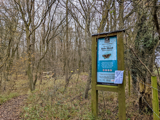 |
| The SW entrance to Balls Wood |
16: When you reach the woodland, and the entrance to the Herts & Middlesex Wildlife Trust's
Balls Wood, turn right, then immediately left, now on Hertford Heath footpath 7, then head E for 450m with the woodland on your left and the field on your right. Continue until you reach the SE edge of Balls wood, where Hertford Heath footpath 7 enters a short stretch of woodland (location -
https://w3w.co/bags.radar.bigger).
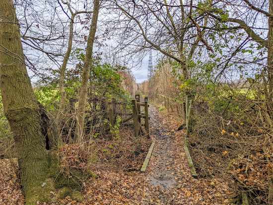 |
| Leave the woodland via the small footbridge then head E |
17: Leave the woodland via a footbridge (location -
https://w3w.co/forces.mile.riches) then continue heading E, still on Hertford Heath footpath 7, for 330m until you reach a T-junction with a track called Elbow Lane, which is also the Roman road known as
Ermine Street (location -
https://w3w.co/origin.labels.video).
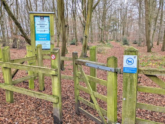 |
| The walk passes Hobbyhorse Wood |
18: Turn left on Ermine Street, which is also Hertford Heath restricted byway 8, then head N for 300m until you reach
Hobbyhorse Wood on the left, another Herts & Middlesex Wildlife Trust nature reserve (location -
https://w3w.co/when.bottom.shiny).
19: Continue heading N, passing Hobbyhorse Wood on the left, for 270m until you reach a junction with a lane on the right (location -
https://w3w.co/marker.trains.circle).
 |
The SW entrance to Hertford Heath
|
20: At this point you could turn right on the lane, which is called The Roundings, or you could take a detour through
Hertford Heath and follow a path that runs parallel through the nature reserve, which is the third Herts & Middlesex Wildlife Trust reserve on this walk. Both routes meet again 350m NE (location -
https://w3w.co/will.fish.photo).
 |
| The College Arms, London Road, Hertford Heath |
21: When you rejoin The Roundings continue heading NE for 250m until you reach the junction with London Road and The College Arms on your left (location -
https://w3w.co/guitar.porch.vest).
 |
| The final stretch of Hertford Heath towards the end of the walk |
22: Cross London Road, then continue heading NE along Heath Lane for 125m until you reach another entrance to Hertford Heath (location -
https://w3w.co/blend.fall.coins).
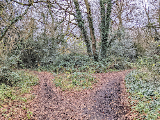 |
| Keep right at the fork then continue heading NE through woodland |
23: Continue heading NE through woodland for 140m until you meet a fork (location -
https://w3w.co/drain.caked.plenty). Keep right and continue heading NE then NW for 430m until you reach Mount Pleasant (location -
https://w3w.co/ending.racks.juices).
24: When you reach Mount Pleasant turn left then head NW for 350m until you reach The Goat and the start/finish of the walk. If you have little ones with you see if they can spot the model cottages along Mount Pleasant.
 |
| A model cottage on Mount Pleasant, Little Amwell |
 |
| A model cottage on Mount Pleasant, Little Amwell |
Interactive map


Did this walk today, 9th January, and having read your comments about waterlogged areas we went prepared with the wellies. I dont think we have ever been on a more puddly and muddy walk but we thoroughly enjoyed it! Quite tiring to walk through when everywhere is so muddy and waterlogged but a very good walk nevertheless. The Foxes Farm Shop looked good but we were so muddy we thought we'd leave it for another time. Thanks again for listing all these great walks.
ReplyDeleteWell done braving the mud and pressing on regardless. Yes, wellies are essential for that walk (and many others at this time of the year). Glad you enjoyed it.
DeleteHi Dave and Ellie another great walk especially on such a lovely day . The point you mentioned between 12-13 is now dry. The footpath at point 15 has now been walked on so no need for detour 👍
ReplyDeleteThanks for that. And thanks for sharing the picture of the gate which I have now added to the directions just after point 12.
DeleteOur first walk using this website. Absolutely fantastic. Very well explained. Only thing we found is that you cannot get through at Foxholes Farm. We had to unbolt a gate which said 'no entry '
ReplyDeleteHi Lorraine,
DeleteI am so glad you enjoyed your first walk on Hertfordshire Walker. But I am sorry to hear you found a locked gate with a 'no entry' sign.
There is a public right of way running through the farm with access to shops and small businesses. Did you use the GPS navigation to make sure you were on the right path?
If so, and if the public right of way was blocked, please report it to Hertfordshire County Council's Rights of Way team so they can look into it.
They have an excellent and intuitive website for reporting such issues.
https://www.hertfordshire.gov.uk/services/highways-roads-and-pavements/report-a-problem/report-a-highway-fault/public-rights-of-way/public-rights-of-way.aspx
Please let me know how you get on. I will head out there as soon as I can to double check my directions, the GPS navigation files and whether the public right of way we have mapped is blocked with a 'no entry' sign. It is against the law for a landowner to block a public right of way.
Thanks for pointing it out.
David
Hi Lorraine,
ReplyDeleteWe revisited Walk 167: Hertford Heath West Loop this morning and the good news is that we didn't come across any blockage across the public right of way, Hertford footpath 44. We did see a sign that read 'No Entry' but that was on the right at a gate where the route turns left. Perhaps you took a wrong turn at that point? I took a photograph of the junction and have inserted it above point 3 in the directions above.
David
It's worth having a look at the mansion whilst walking through Balls Park. Just from the outside of course as it's now private apartments but you can get a sneaky peek of the gardens from the surrounding footpaths. I'd only ever driven past and it was a pleasant surprise on the walk.
ReplyDeleteHistory of the site:-
https://en.m.wikipedia.org/wiki/Balls_Park
Thanks for that. I have updated the walk's directions with that information. Kind of you to share it.
DeleteDavid
We completed this walk on 5 August 2022, although with a significant detour. One of the gates between fields between 12 and 13 was blocked by about 50 cows and we didn't feel confident enough to force our way though them having had a bad experience with cows previously on another walk. We retraced our steps to Morgan's Walk and headed south. At the end of Morgan's Walk we turned right and followed a footpath to Brickendon Lane, where we headed south. We took the BOAT at Edwards Green Farm and then turned left onto another BOAT which led to Blackfields Farm. We turned right on the road and picked up walk 167 again between 15 and 16. We successfully completed the rest of the walk, which we enjoyed. Our experience showed the importance of always carrying an OS map!
ReplyDeleteHi Richard, sorry your walk had to be rerouted because of the cows, but glad you found an alternative route. Well done. You are right, it's always good to carry an OS map just in case a path is blocked for any reason. Dave
DeleteGreat walk, completed it this afternoon. The map says over 5.6 but the write up says 5.3, I thought I'd gone wrong somewhere.
ReplyDeleteYou are right, I am wrong.... it's 5.7 miles. Sorry. Hope it didn't spoil your day. I have edited the directions and fixed it. Apologies. Dave
DeleteGreat walk. Great directions, very wet at one point. Really enjoyed it. Will go again.
DeleteGreat, glad you enoyed it, despite the wet. Thanks for the feedback.
Delete