7.5 miles (12 km) with 58m of total ascent
 |
| Pirton footpath 5 between points 2 & 3 |
This walk is mainly flat, following well-defined paths across the rolling countryside of northwest Hertfordshire. The route crosses Toot Hill motte and bailey castle and shrunken medieval village at Pirton, passes three pubs, and is close to two more. We have marked a well-positioned bench at roughly the halfway mark which makes an ideal spot for a picnic.
Getting there
There are bus stops near Ickleford Stores (location -
https://w3w.co/configure.panning.reception) close to the start of the walk which are served by the number 9A bus. There are also bus stops close to the junction of Bedford Road and Turnpike Lane (location -
https://w3w.co/snowstorm.rescue.adjust) served by the numbers 9B, 74, and 89. You can check bus times at
Intalink.
Fly through preview of walk
If you want to check what sort of landscape you will be crossing before you set off on this walk you can view a short 3D video of the route below. It's created using the free version of
Relive.
Directions
 |
Map for Walk 155: Ickleford Loop
Click on the map for a larger version
Created on Map Hub by Hertfordshire Walker
Elements © Thunderforest © OpenStreetMap contributors
There is an interactive map below the directions |
Those with GPS devices can download
GPX or
KML files for this walk. We've added
What3Words location references for those who use that system. If you print these walks you might want to use the green
PrintFriendly icon at the bottom of these directions to delete elements such as photographs.
 |
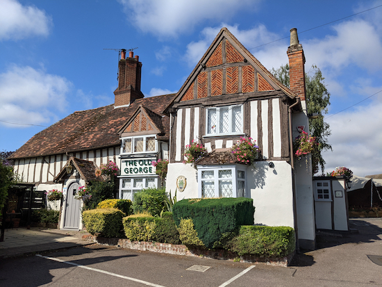
| The Old George, Ickleford |
1: With your back to The Old George (location -
https://w3w.co/snippets.vague.obstruct) in Ickleford, turn right then head SW on Turnpike Lane for 550m until you reach the junction with Bedford Road (location -
https://w3w.co/footsteps.standard.situation). This first section is a fairly busy road, but there is a pavement for pedestrians.
Cross Bedford Road then continue heading SW, now on Westmill Lane, for 810m until you reach a junction with a bridleway on the right (location -
https://w3w.co/predict.equipping.hems), see image below.
 |
| The right turn off Westmill Lane leading to Ickleford bridleway 19 |
2: Turn right on Ickleford bridleway 19, which is also the
Hitchin Outer Orbital Path at this point, then head NW for 360m until you reach a junction (location -
https://w3w.co/openly.stale.relocated), see image below.
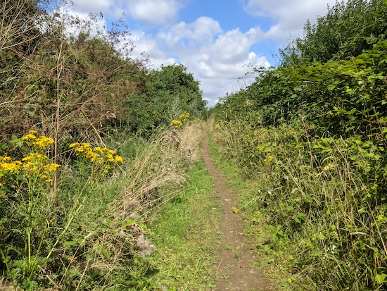
 |
| Pirton footpath 5 turning left at the fork |
Take the left fork at the junction then head W on Pirton footpath 5 for 1.6km to a junction and a gate (location -
https://w3w.co/included.woes.handyman). Go through the gate then continue heading W for 340m with Pirton recreational ground on your left and the hedgerow on the right, then walk through the car park and emerge on Walnut Tree Road (location -
https://w3w.co/idealist.pull.wool).
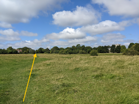
3: Cross Walnut Tree Road, take the footpath in the hedgerow, then head W for 220m crossing the
Toot Hill motte and bailey castle and shrunken medieval village. To make sure you take the right path, follow the line of the yellow arrow in the image below.
 |
| Toot Hill motte and bailey castle and shrunken medieval village |
After crossing the Toot Hill site you will reach a gate in the corner of the field (location -
https://w3w.co/snoozing.winning.deny), see image below. The gate leads to a lane called Bury End.
 |
| The gate leading to Bury End |
Go through the gate, turn right, then follow the lane round to the right and continue past the front of the
Motte and Bailey pub on the right (location -
https://w3w.co/sheep.cups.should), see image below.
 |
| The Motte & Bailey in Pirton |
4: Keep right after passing the Motte & Bailey pub, then head NE along Crabtree Lane for 250m until you reach the junction with High Street (location -
https://w3w.co/chuckling.sweetener.likely).
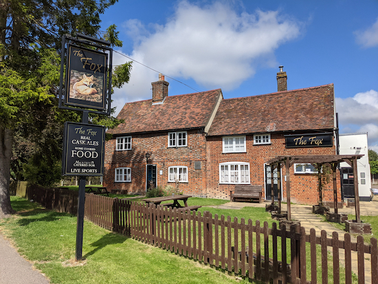
The Fox pub will be opposite (location -
https://w3w.co/fussed.void.unclaimed), see image below.
 |
| The Fox, High Street, Pirton |
Turn right on High Street then head SE for 190m passing the village shop and post office on the left (location -
https://w3w.co/implanted.charm.community) and Blacksmith's Pond on the right (location -
https://w3w.co/analogy.imposes.offstage) and continuing until you reach a junction, with Hambridge Way opposite (location -
https://w3w.co/superbly.blinks.acrobat).
5: Continue heading E on Hambridge Way for 80m until the track becomes Pirton bridleway 21 (location -
https://w3w.co/intelligible.tools.named), which is also the
Icknield Way along this stretch. Continue for 1.6km at which point you will find a stone bench on your left (location -
https://w3w.co/magazines.carbon.specifies) with a great view to the south; an ideal spot for a picnic, see images below.
 |
| The bench on the left along Pirton bridleway 21 |
 |
| The view south from the stone bench on Pirton bridleway 21 |
Continue along bridleway 21 for 350m until you reach a junction with a path on the left (location -
https://w3w.co/possibly.novelists.film), see image below.
 |
| Pirton footpath 6 heading N off Pirton bridleway 21 |
6: Turn left then head N on Pirton footpath 6, first across a field then alongside a sand quarry, see image below.
 |
| Pirton footpath 6 with the sand quarry on the right |
Continue N for 920m at which point the footpath becomes Holwell footpath 14 (location -
https://w3w.co/informal.tidal.starch) then continues heading N for 530m until you reach Pirton Road (location -
https://w3w.co/smirking.repay.parent).
7: Turn right on Pirton Road then head N for 30m looking for a footpath on the right (location -
https://w3w.co/informal.beamed.incensed). Take this footpath, Holwell footpath 5, then head E for 1.2km until you reach Bedford Road (location -
https://w3w.co/cakewalk.nipping.inflates).
8: Cross Bedford Road (it can be busy), then turn right and walk along the pavement heading S for 60m until you reach a bridleway on the left (location -
https://w3w.co/auctioned.ooze.stared). Take this bridleway, Ickleford bridleway 4, then head E for 950m then S for 480m until you reach the junction with Arlesey Road (location -
https://w3w.co/ironclad.sentences.expose).
 |
| Ickleford bridleway 4 heading east |
9: Turn left on Arlesey Road then head ESE for 180m until you reach the railway bridge. There are two footpaths on the right. Take the one closest to the railway bridge to the left of the last house (location -
https://w3w.co/cheesy.veto.engrossed), see image below.
 |
| Ickleford footpath 20 heading south of Arlesey Road |
Turn right on this footpath, Ickleford footpath 20, which is also The Hicca Way at this stage, then follow it SSW for 700m to a junction (location -
https://w3w.co/elevate.easygoing.catching).
 |
| Ickleford footpath 20, also the Hicca Way, between points 9 & 10 |
10: Turn right on Ickleford BOAT 18 (byway open to all traffic) then continue following the track W for 330m over a wooden bridge back to Ickleford and the starting point.
There are three pubs in Ickleford,
The Old George,
The Plume of Feathers (location -
https://w3w.co/midwinter.shame.invent), and
The Cricketers (location -
https://w3w.co/snooping.globe.slid).
Thanks to our occasional walking companions, Sophie and Mike, for inspiring us to explore this northwestern tip of Hertfordshire.
Interactive map


No comments:
Post a Comment
Comments and feedback
If you try any of the walks on this site, please let us know what you thought of them by adding a comment here or on our members-only Facebook group. Comments here are checked before they are published. Comments on the Facebook group go live immediately.