7.1 miles (11.5 km) with 99m of total ascent
 |
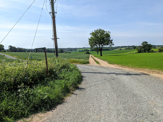
| The bridleway between points 6 & 7 |
This is one of our favourite walks in the collection. It starts in the village of
Wheathampstead which has several cafes and restaurants and three pubs. There is a car park which, at the time of writing, is free of charge. The route follows the Lea Valley Walk before following a disused railway branch line, the Ayot Greenway, then looping round to the north passing close to two more pubs before returning to Wheathampstead.
Fly through preview of walk
If you want to check what sort of landscape you will be crossing before you set off on this walk you can view a short 3D video of the route below. It's created using the free version of
Relive.
Directions
 |
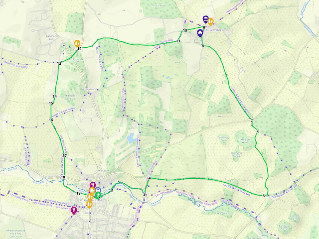
Map for Walk 143: Wheathampstead North Loop
Click on the map above for a larger version
Created on Map Hub by Hertfordshire Walker
Elements © Thunderforest © OpenStreetMap contributors
There is an interactive map below these directions |
Those with GPS devices can download
GPX or
KML files for the walk. We've added
What3Words references for those who use that system. If you print these walks you might want to use the green
PrintFriendly icon at the bottom of these directions to delete elements.
Park in the East Lane car park in Wheathampstead (location -
https://w3w.co/rated.empire.held). The parish council's website says that
parking is free of charge, but check in case the situation has changed since these directions were written. When parking make sure you park in the local authority car park and not the one adjacent belonging to The Bull pub, which is for customers only.
1: Leave the East Lane car park turn left and head NE along East Lane and then along Meads Lane for 190m until it becomes a track (location -
https://w3w.co/shady.cafe.signal). This is the
Lea Valley Walk. Continue heading NE, now on Wheathampstead footpath 71, for 30m until you reach a footpath on your left leading to a footbridge over the River Lea (location -
https://w3w.co/ranges.comet.club).
 |
| Turn left over the footbridge to join the Lea Valley Walk - point 1 |
2: Turn left and head NNW and cross the River Lea. This is a great spot for paddling. Immediately after crossing the river turn right, still on the Lea Valley Walk (location -
https://w3w.co/quite.needed.cable) and follow it NE then E for 220m until you join Wheathampstead bridleway 12 (location -
https://w3w.co/twig.builds.bunk). Turn right and follow this bridleway SE, E, then SE again for 430m until you reach a left turn leading to a junction (location -
https://w3w.co/legend.finishing.grain).
3: At the junction turn left on Wheathampstead BOAT 4 (byway open to all traffic) and head NNE and uphill for 270m until you reach
Ayot Greenway (location -
https://w3w.co/points.mugs.final). The Greenway is the route of the former branch line between Welwyn Garden City, Luton and Dunstable.
 |
| The right turn leading to Ayot Greenway - point 3 |
4: Turn right on Ayot Greenway and follow it E for 2km until you reach a footpath on the left shortly before a bridge (location -
https://w3w.co/fade.noble.roof).
 |
The view south from Ayot Greenway between points 4 & 5
|
 |
| Turn left before the bridge and take Wheathampstead footpath 89 |
5: Turn left on Wheathampstead footpath 89 and follow it uphill and ENE for 55m until you reach a track. Turn left on the track, still on Wheathampstead footpath 89, and head N, NW, then NE for 1.2km until you reach a footpath junction (location -
https://w3w.co/curve.mining.calls). This section was ablaze with rose bushes when we did this walk mid June.
 |
| Rose bushes along Wheathampstead footpath 89 |
6: When you reach the junction, turn left on Wheathampstead bridleway 11 - which is also Ayot St Peter bridleway 16 at this point - and head NW for 200m until you reach Codicote Road (location -
https://w3w.co/spins.amused.liked).
* For those interested in why some footpaths, bridleways or byways have two parish names, it usually means that the public right of way straddles a parish boundary.
 |
| Turn left at the junction - point 6 |
7: Cross Codicote Road and continue on Wheathampstead bridleway 11 - which at this point is also Ayot St Lawrence bridleway 2 - and head NNW for 760m.
* Soon after crossing Codicote Road you pass Stocking Springs Wood on your right (location - https://w3w.co/passes.closes.yours). You can wander through this Herts & Middlesex Wildlife Trust nature reserve on a path parallel that runs parallel to our route and rejoin it further along.
 |
| The southern entrance to Stocking Springs Wood |
Soon after the Stocking Spring Wood path rejoins the route from the right (location -
https://w3w.co/finds.dips.humid), the bridleway you are on continues as Ayot St Lawrence bridleway 2 but is also Wheathampstead bridleway 1 for this section. Continue heading NNW for 770m until you reach Bride Hall Lane (location -
https://w3w.co/frog.teeth.forks).
8: Turn right on Bride Hall Lane and head N. After 160m you will pass
Shaw's Corner on your left (location -
https://w3w.co/charge.hung.mull). This is the former home of the author
George Bernard Shaw (1856 – 1950) which is now maintained by The National Trust. Continue for 150m until the road bends to the right with a gravel track on your left (location -
https://w3w.co/mull.cave.boring).
* At this point you could take a short detour to the right to visit the ruins of the old Ayot St Lawrence church (location - https://w3w.co/grapes.basket.flips) and then on to The Brocket Arms pub/restaurant (location - https://w3w.co/both.universally.city).
 |
| The ruins of the old church in Ayot St Lawrence |
9: If you don't take the detour, turn left on a gravel track and head NW for 20m until you reach a gate (location -
https://w3w.co/unrealistic.boxer.dash), see image below. Go through the gate and turn left on Ayot St Lawrence footpath 6. Head WSW on this footpath for 290m until you reach a three-way junction with a track going off to your right and Bibbs Hall Lane on your left (location -
https://w3w.co/wash.range.weedy).
 |
| Go through the gate and turn left on Ayot St Lawrence footpath 6 |
10: Turn right on Bibbs Hall Lane and head WSW for 40m looking out for a footpath on your left (location -
https://w3w.co/skins.driver.player). Take this path, Kimpton footpath 13, and head SW for 160m to a footpath junction (location -
https://w3w.co/bricks.powder.filed).
11: Turn right at the junction, still on Kimpton footpath 13, and follow it ESE for 220m until you reach a footpath crossing (location -
https://w3w.co/leader.trials.stand). Continue heading W, now on Wheathampstead footpath 36, ignoring footpaths to your right and left. Follow this footpath for 900m until you reach Lamer Wood (location -
https://w3w.co/learn.assure.suffice) where Wheathampstead footpath 36 is also Kimpton footpath 12 for 650m until you reach Ballsclough Hill (location -
https://w3w.co/flap.coffee.always).
12: Turn left on Ballsclough Hill and head SW for 190m passing the
Cross Keys pub/restaurant on your right (location -
https://w3w.co/alien.smooth.paint) and continuing until you reach Kimpton Road (location -
https://w3w.co/detect.store.index). Cross Kimpton Road and head SW along The Slype which runs across Gustard Wood Common for 230m before reaching a lane called Gustard Wood, which is also Wheathampstead bridleway 103 (location -
https://w3w.co/headed.claps.rinse).
 |
| The left turn leading to Wheathampstead bridleway 103 - point 13 |
13: Turn left on this bridleway and head S for 540m until you reach a bridleway junction (location -
https://w3w.co/dragon.wheels.fell), see image below.
 |
| Continue heading S now on Wheathampstead bridleway 58 - point 14 |
14: Continue straight, heading S now on Wheathampstead bridleway 58 for 150m with the barn on the right and the golf course on the left, and follow the track round as it turns right and heads W at the end of the barn before reaching a junction (location -
https://w3w.co/shorts.dogs.host).
 |
| Wheathampstead bridleway 58 heading S in the direction of the trees |
15: Turn left, still on Wheathampstead bridleway 58, and head S for 260m until you reach another junction (location -
https://w3w.co/ranked.bridge.cool) just beyond a tree, see image below.
 |
| Keep to the left after the tree, now on Wheathampstead bridleway 10 |
16: Continue heading S then SSE, now on Wheathampstead bridleway 10, until you reach farm buildings on the right (location -
https://w3w.co/format.vocal.wells).
 |
| Poppies in the hedgerow between points 16 & 17 |
17: After you pass the farm buildings take the footpath on the right, Wheathampstead footpath 59 (location -
https://w3w.co/spirit.water.smug), see image below, and head S for 340m until you reach Lower Luton Road (location -
https://w3w.co/blog.crisis.circle).
 |
| The gate leading to Wheathampstead footpath 59 |
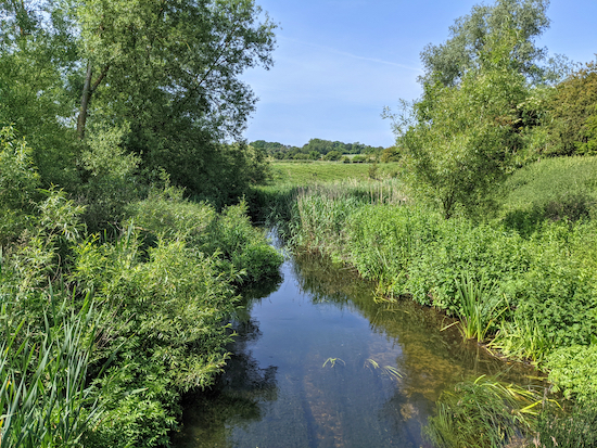
18: Cross Lower Luton Road and take Wheathampstead footpath 64 on the opposite side. Follow this footpath S crossing the River Lea, see image below.
 |
| Wheathampstead footpath 64 crossing the River Lea - point 18 |
Continue along Wheathampstead footpath 64, now heading SE, for 390m until you reach a play area (location -
https://w3w.co/kept.weeks.mint), see image below.
 |
| Keep to the left of the play area - point 19 |
19: Keep to the left of the play area and continue heading SE for 200m to High Street, Wheathampstead (location -
https://w3w.co/ramp.rigid.washed). Cross High Street and head ESE along East Lane for 100m back to the car park.
There are a number of places to eat in Wheathampstead and three pubs close to the start and finish point. They are
The Bull (location -
https://w3w.co/flown.rents.sage),
The Reading Rooms (location -
https://w3w.co/just.square.snake), and
The Swan (location -
https://w3w.co/forgot.cooks.when).
Walkers have recommended three cafes in Wheathampstead,
Loafing (location -
https://w3w.co/ready.sweat.wooden),
Marley's (location -
https://w3w.co/driven.sheet.cheeks), and
Brewhouse Coffee (location -
https://w3w.co/unions.trace.fats)
If you enjoyed this walk please consider joining our
Hertfordshire Walker members-only Facebook Group where you can share photos and comments on your walking experiences.
Interactive map


Took this walk on Wed August 18th. Really pleasant walk with a nice downhill finish. Never realised I had climbed so much. There is a nice cafe on the left as you enter Wheathampstead High Street at the finish.
ReplyDeleteAgreed, a pleasant and varied walk. Thanks for the tip about the cafe in Wheathampstead.
ReplyDeleteDavid
An absolutely lovely walk, thank you. Great history with the railway trail (you can see the reconstructed station platform at the top of Station Road at the junction with Codicote Road, a short detour before/after the walk), and some nice views, to boot. Worth noting that at point 9, after the gate, you can take Ayot St Lawrence Footpath 5 on the right to visit Ayot St Lawrence New Church (the Greek styled building in the picture). There are very tame sheep in the field which lies just beyond a second gate before the church. Once in the grounds you can join Ayot St Lawrence Footpath 6 which runs down the Church drive and meets Bibbs Hall Lane, just before the second part of point 10, the left turn onto Kimpton Footpath 13.
ReplyDeleteHi Steve,
DeleteGreat info. Thanks for adding. I love it when comments improve the overall information for each walk. Thanks a lot. Keep up the good work.
:-)
David
We enjoyed this walk yesterday - many thanks for sharing. No problems with the navigating. We chose to walk along the Lea Valley Way for part of the outward leg between points 3 and 5 rather than entirely along the Ayot Greenway. as we like being down by the river. We particularly enjoyed the stretch between points 5 and 6 as the sun was shining and the views over the countryside are lovely.
ReplyDeleteHi, I totally agree; it's a lovely walk and one we return to regularly, particularly on a crisp and sunny autumnal day. Thanks for sharing the tips about detours. It's really nice when fellow walks make suggestions that others might enjoy trying. Dave
ReplyDeleteThis is a new favourite - done 2 weeks ago. Will definitely be back to this pretty area with lots of interest to see.
ReplyDeleteYes, we like it too. At 7.2 miles it's quite a hike, but well worth the effort. If you haven't already done so, please consider of joining our members-only Facebook group where fellow walkers are posting about their walks and sharing photos taken along the way.
Deletehttps://www.facebook.com/groups/hertfordshirewalker
Lovely walk. Muddy in places but nothing that can't be walked around. The car park at the beginning is still free although be careful if using Apple Maps to get to it, it tries to take you up a cul de sac. If, like me, you have a golfer walking with you, they will particularly enjoy the area around section 14- plenty of stray golf balls to collect!
ReplyDeleteHi David, thanks for the update. Glad you enjoyed the walk. It's one we enjoy revisiting.
Delete