8.1 miles (13 km) with 131m of total ascent
 |
| A bridleway along the route |
Fly through preview of walk
If you want to check what sort of landscape you will be crossing before you set off on this walk you can view a short 3D video of the route below. It's created using the free version of Relive.
Directions
Those with GPS devices can download GPX or KML files for this walk. We've added What3Words location references for those who use that system. If you print these walks you might want to use the green PrintFriendly icon at the bottom of these directions to delete elements such as photographs.
Park in the Heartwood Forest car park (location - https://w3w.co/flags.enable.offer) and head for the exit in the southern corner, see image below (location - https://w3w.co/oddly.goats.hits).
 |
| The exit from the car park to Sandridge bridleway 8 |
Take this track and head SSW for 110m until the track meets Sandridgebury Lane (location - https://w3w.co/handed.ranked.parts). Turn right on Sandridgebury Lane and head SW for 200m looking for a bridleway on the right, see image below (location - https://w3w.co/wider.error.supper).
 |
| Sandridge bridleway 9 heading WNW off Sandridgebury Lane (point 2) |
After crossing the railway continue heading W for 550m, still on Sandridge bridleway 9. Pass through Cheapside Farm, and continue until you reach a junction in the track (location - https://w3w.co/stays.hook.river).
Turn left then right and head SW, now on St Michael Rural bridleway 1A, for 380m until you reach Harpenden Road (location - https://w3w.co/studio.export.filed).
3: Cross Harpenden Road and take St Michael Rural bridleway 1 on the other side. Head SW through the Hawkswick Lodge Fruit Farm (see image below) for 350m and continue through the fruit fields until you reach woodland (location - https://w3w.co/snail.repair.sheets).
 |
| The bridleway through Hawkswick Fruit Farm (point 3) |
 |
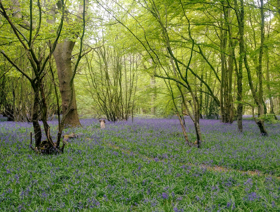
| Bluebells in the woodland S of Hawkswick Lodge Fruit Farm |
4: Head SSW, passing the school on the left before reaching a road. Continue heading SW along the road with housing on the left and fields on your right for 250m until you reach Batchwood on the right.
Just before you reach Batchwood, look out for a path (location - https://w3w.co/shades.chemistry.ozone) which runs through the woodland - which was also carpeted in bluebells in late April - and heads SSW parallel to the road you just left on your left.
Continue for 340m before exiting the woodland to your left just before reaching the golf course (location - https://w3w.co/neck.daring.translated), see image below.
 |
| Turn left and exit Batchwood and then head SE |
Turn right here and follow the bridleway across the golf course heading SSW for 940m until you reach a bridleway junction and a lane at the southern edge of the golf course (location - https://w3w.co/events.counts.moon).
5: Turn right on St Albans City bridleway 88, which is also a lane (although some people walk parallel to the lane either inside the golf course or on the other side of the lane).
Head NW for 300m until you reach St Michael Rural bridleway 2 on your left (location - https://w3w.co/island.chief.mess).
 |
| Bridleway 2 heading NW off bridleway 88 (point 5) |
6: Turn right on School Lane and follow it SE and then NE for 410m until you reach Harpenden Road (location - https://w3w.co/valve.dogs.last).
Turn right on Harpenden Road then head SE along a track on the S side of the road for 310m until you reach a bridleway on the left (location - https://w3w.co/slap.bring.grades). This is the track you walked along just before point 3 above.
7: Turn left on St Michael Rural bridleway 1A and follow it heading NE and then NNW for 380m until you reach the junction you passed earlier in the walk (location - https://w3w.co/bottle.daisy.tight), see image below.
 |
| Head straight ahead and NW at the junction referred to in point 7 |
8: Continue along this track as it reaches a right-hand bend (location - https://w3w.co/inform.rent.pine) and, after another 45m, comes to a left-hand bend (see image below).
 |
| The gap in the hedgerow mentioned in point 8 below |
9: Turn right on Ayers End Lane and head NE for 290m until you cross the railway track. Continue heading NE on Ayers End Lane for another 210m looking out for a bridleway on the right (location - https://w3w.co/loans.matter.lime). This is Wheathampstead bridleway 9.
10: Take this bridleway and head SSE for 540m until you reach a crossing in the track (location - https://w3w.co/shovels.awards.list).
11: Here the track becomes Sandridge bridleway 8 which you follow SE for 1.8km back to the car park.
Along the way you will pass the entrance to the Magical Wood on your left (location - https://w3w.co/flags.liability.locker) and Langley Wood on the right (location - https://w3w.co/bench.relay.speaks).
You can cut through Langley Wood and follow a track parallel to your route in order to enjoy the bluebells in spring (see images below).
 |
| The bluebell track through Langley Wood |
 |
| The bluebells in Langley Wood in late April |

Very easy to park at Heartwood Forest - free with plenty of spaces. Lovely walk with a decent amount of shady spots on a hot summer’s day, but a hat was needed for the open spaces. Walking through the fruit farm was especially nice. Excellent directions as always, thank you. We finished at the Potting Shed Cafe in Carpenters Nursery (just south of Sandridge) where the staff took interest in our walk and this website!
ReplyDeleteThanks for the report on the walk. Thanks for sharing the cafe tip. Brave to set off in this heat! Respect. It is a nice walk. We enjoyed testing it. Must do it again. David
Delete