5.5 miles (8.9km) with 112m of total ascent
 |
| The footpath between points 2 and 3 below |
Fly through preview of walk
If you want to check what sort of landscape you will be crossing before you set off on this walk you can view a short 3D video of the route below. It's created using the free version of Relive.
Directions
GPX or KML files for this walk. We've added What3Words location references for those who use that navigation system. If you print these walks you might want to use the green PrintFriendly icon at the bottom of these directions to delete elements you don't need.
1: With your back to The Red Lion pub/restaurant (location - https://w3w.co/froze.heave.pounds) turn left then head SW for 100m until the road becomes a footpath.
Continue SSW then SW along Preston footpath 3 for 190m until you reach Back Lane (location - https://w3w.co/enter.clips.smashes).
2: Turn left on Back Lane then head SE for 230m passing Preston Primary School on the left and continuing to the junction with Crunnells Green (location - https://w3w.co/safety.solo.dining).
3: Take the right fork then head SSE for 210m until you reach a footpath on the right (location - https://w3w.co/ruby.them.affair).
 |
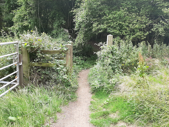
| The gate mentioned in point 2 |
5: Turn left, still Preston footpath 12, which drops down to a gate on the right (location - https://w3w.co/broom.manuals.cheerily).
 |
| Preston footpath 12 crossing an arable field |
6: Cross the lane then take Kings Walden footpath 30 almost directly opposite (location - https://w3w.co/providing.ranks.political).
Follow Kings Walden footpath 30 uphill and SW across an arable field for 480m.
When you reach the far side of the field head to the right of a large hay barn (location - https://w3w.co/tiredness.hypnotist.freedom).
Go through a gap to the left of a large metal gate to reach Taylors Hill Road (location - https://w3w.co/meanest.bookcases.gashes).
7: Turn left on Taylors Hill Road then head SW for 50m to a junction (location - https://w3w.co/buyers.verse.supposes).
Turn right on Whitehall Road then head NW for 100m until you reach Whitehall Lane (location - https://w3w.co/qualified.this.enjoys).
8: Turn right on Whitehall Road then head NNE and then NNW for 140m until Whitehall Road becomes Kings Walden BOAT 45 (byway open to all traffic), (location - https://w3w.co/cools.action.chest).
9: Continue on Kings Walden BOAT 45 heading NNE for 100m until you reach a footpath on your left which is often hidden in the hedgerow (location - https://w3w.co/overused.dusted.handfuls).
 |
| Kings Walden footpath 26 |
11: Cross Parsonage Lane then continue heading NW for 300m until you reach Plough Lane (location - https://w3w.co/encourage.schematic.drilled).
On the left you will see The Plough pub which, in July 2024, was undergoing renovation (location - https://w3w.co/donor.pleasing.untruth).12: Cross Plough Lane then continue heading NW for 245m until you reach School Lane at Ley Green (location - https://w3w.co/motivations.hurtles.gently)
 |
| Kings Walden footpath 29 |
Head NE along this residential road for 75m, first NE and then NW, until you reach a footpath on the right immediately after 1 Crown Cottage on your right (location - https://w3w.co/accordion.code.crust).
14: Turn right on Kings Walden footpath 29 then head NE for 450m with the hedgerow on the right and the field on the left. Continue until you reach Austage End Lane (location - https://w3w.co/chins.pump.loitering).
15: Turn left on Austage End Lane then head first NNW and then NNE for 360m to Austage End. Continue until the lane becomes Kings Walden restricted byway 47 (location - https://w3w.co/backward.mysteries.wired).
Continue heading NNE for 50m until the track you are on becomes Kings Walden bridleway 28 at the point where the track forks, see image below (location - https://w3w.co/eyelid.contemplate.bids).
 |
| Take the left fork, Kings Walden bridleway 28 |
17: Turn right on Preston bridleway 11 then head E for 890m to Charlton Road (location - https://w3w.co/approach.canny.timer).
18: Cross Charlton Road then take the track diagonally opposite to your left. This is Preston bridleway 15, also known as Tatmorehills Lane.
Head NE on Preston bridleway 15 for 410m until you reach woodland (location - https://w3w.co/polygraph.shredding.financial). At this point the bridleway you are following crosses a parish boundary where it becomes Ippollitts bridleway 5.
 |
| Ippollitts bridleway 5 mentioned in point 19 |
 |
| Ippollitts footpath 6 mentioned in point 20 |
 |
| The gate at the start of Preston footpath 13 |
 |
| The permissive path on the left leading to Wain Wood |
 |
| Noticeboard in Wain Wood, a Site of Special Scientific Interest |
 |
| Leaving Wain Wood to rejoin Preston footpath 13 |
24: Turn left on Chequers Lane then follow it SE for 260m to Hitchin Road (location - https://w3w.co/orchestra.deaf.plant).
25: Turn right on Hitchin Road then follow it SSE for 120m back to the starting point.


Lovely walk. Nice mix of landscapes and some fantastic views. Really enjoyed it, thank you. Also, the Plough seems to be undergoing a major referb, and is closed.
ReplyDeleteSteve.
thanks for the tip about The Plough.
DeleteThe Plough in Kings Walden reopened yesterday (01/08/2024) - beautifully refurbished and well worth a visit.
ReplyDeleteYes, good to have The Plough open again. It features on several of our walks.
Delete