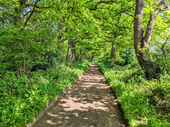
3.5 miles (5.6 km) with 40m total ascent
 |
| Green Street looking back towards point 10 |
This is an extension of the shorter
Wildhill Loop, which is walk six in this series. We’ve added it because it has been one of our regular walks during the coronavirus lockdown of 2020, when we wanted a walk that was quiet and which we could enjoy without meeting too many people. It starts and finishes at
The Woodman, Wildhill. The walk includes a section called Green Street, which is a lovely 2km stretch of wooded byway.
Directions
 |
Map for Walk 99: Woodside Loop
Created on Map Hub by Hertfordshire Walker
Elements © Thunderforest © OpenStreetMap contributors
There is an interactive map below the directions |
Those with GPS devices can download
GPX or
KML files for this walk. We've added
What3Words location references for those who use that navigation system. If you print these walks you might want to use the green
PrintFriendly icon at the bottom of these directions to delete elements you don't need.
1: Go through the gate in the SW corner of The Woodman car park (location -
https://w3w.co/newly.wiser.open) and follow the footpath, Hatfield footpath 84, for 300m as it heads SSW. Cross a wooden bridge, go through another gate, and follow the path until it crosses another wooden footbridge.
2: After the bridge go through a gate on your left and then turn right (location -
https://w3w.co/tribune.author.over). Head WSW then SW for 200m, with the field on your left and the hedgerow on your right until you reach a gap in the hedge on the right (location -
https://w3w.co/slam.watch.zones). Look out for buzzards and red kites over your head.
 |
| Head uphill and SW with the hedgerow on the right and the field on the left |
3: Go through the gap, cross a small stream that runs through a pipe underfoot, then follow the path uphill heading SW, with the field on your left and the hedgerow on your right, see yellow arrow on the image above.
 |
| Head diagonally uphill towards a tree on the left (see yellow arrow) |
4: After 240m the path veers left (location -
https://w3w.co/twig.rings.boxing) heading diagonally uphill for 110m towards a tree on the left across a field (location -
https://w3w.co/games.gross.damp), see yellow arrow on the image above. Continue SW for 410m, with the woodland on your right and the field on your left, until you reach a gate leading to Grubbs Lane (location -
https://w3w.co/song.remind.small).
 |
| The view from the top of the hill after point 4 looking back towards Wildhill |
5: Turn right on Grubbs Lane and head NE for 230m looking out for a footpath on your right soon after Westfield Lodge (location -
https://w3w.co/blitz.wants.pardon), see image below.
 |
| The footpath heading NNW off Grubbs Lane 60m beyond Westfield Lodge |
6: Turn right off Grubbs Lane on Hatfield footpath 82 then cross the fields walking diagonally NNW for 610m heading to the left of the pylon. Continue through another field for 230m heading for the woodland, then follow the path for another 280m NW then WNW until you reach an area where farm equipment and building rubble is stored (location -
https://w3w.co/acid.relax.frost).
 |
| Turn left through the building material, see yellow arrow on image |
7: Turn left through the building material (see direction of yellow arrow on the image above), then head SW on Hatfield footpath 81 for 380m, keeping the hedgerow on your right and the field on your left, cross a field and emerge on Grubbs Lane (location -
https://w3w.co/table.treat.guides).
8: Turn right, then right again on Woodside Lane and head NW for 220m where you take the right fork (location -
https://w3w.co/flags.spots.humble) and continue along Woodside Lane until you meet Wildhill Road (location -
https://w3w.co/cross.richer.retain) opposite a large house with metal railings called St Michaels.
9: Turn right on Wildhill Road then head NE for 50m before turning left along a byway that heads NW alongside St Michaels (location -
https://w3w.co/phones.shiny.coast). This byway is called Green Street. It is also Hatfield BOAT 80 (byway open to all traffic). Follow this tree-lined byway as it heads NW, then NE, then E for 1km.
 |
| The lovely Green Street heading E beyond point 10 |
10: After 1km you will reach a junction (location -
https://w3w.co/lock.libraries.hype). Ignore the byway on your right and continue heading E for 850m until you reach West End Lane (location -
https://w3w.co/frozen.silver.snake).
11: Turn right on West End Lane and head S for 600m, following the lane to the T-junction (location -
https://w3w.co/fuel.full.rental). Turn left and return to The Woodman car park.
Interactive map


Lovely walk…
ReplyDeleteDid this walk again today - freezing cold but beautiful blue sky and sunshine. Didnt meet a single soul on the entire route. Really lovely walk, thank you.
ReplyDeleteExcellent day for walking. We are out mapping a new walk, number 163.
DeleteDavid
Thanks for the updated version David. Our "Walk & Talk' group did this lovely walk again this morning - and didn't get lost!!
ReplyDeleteGreat news Pat, so glad you enjoyed it. Thanks for letting me know.
DeleteDavid
We did this walk today. A bit soggy after all the rain, and I didn't get to stop in at the pub (thanks Dry January!), but very enjoyable nonetheless. Thanks for all your hard work mapping these out. Looking forward to trying more
ReplyDeleteHi Matt, glad you enjoyed the walk - despite the soggy conditions. And respect for doing dry January. Must have been hard to pass The Woodman and not go in. If you haven't already done so pleased consider joining our friendly Facebook group where fellow walkers are sharing their walking experiences. David
ReplyDeletehttps://www.facebook.com/groups/hertfordshirewalker