5 miles (8.2 km) with 132m total ascent
 |
| Cows paddling in the River Rib between points 3 and 4 below |
This is a lovely circular route along two sides of the River Rib valley, with wonderful wide-open views across the rolling Hertfordshire countryside. Along the walk you cross the river several times at footbridges adjacent to fords where there are opportunities for dogs, kids, and older folk to dip their feet in the water. It’s quite a hilly route with a total of 410ft of ascent over the course of the five miles. But the climbing is worth it for the views. There are several sympathetically placed benches along the way. The route includes parts of
The Harcamlow Way and
The Greenwich Meridian Trail.
Note: If you are planning to do this walk in July, please check the
Standon Calling website first. Standon Calling is an
annual music festival which occupies part of the route and could result in paths being closed.
Directions
 |
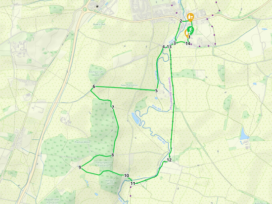
Map for Walk 104: Standon S Loop
Created on Map Hub by Hertfordshire Walker
Elements © Thunderforest © OpenStreetMap contributors
There is an interactive map below the directions |
Those with GPS devices can download
GPX or
KML files for this walk. We've added
What3Words location references for those who use that navigation system. If you print these walks you might want to use the green
PrintFriendly icon at the bottom of these directions to delete elements you don't need.
1: With your back to The Star pub (location -
https://w3w.co/transcribes.remotes.trickles) turn left then head N along High Street for 240m to Stortford Road (location -
https://w3w.co/currently.walks.locked). Turn left on Stortford Road then head W for 160m crossing the
River Rib looking out for a footpath on your left (location -
https://w3w.co/marzipan.hoot.piled).
2: Turn left on this path, Standon
footpath 15, and head SSW for 350m, crossing the River Rib along the way (location -
https://w3w.co/converged.improvise.coats) and continuing until you reach a junction (location -
https://w3w.co/servers.drooling.camcorder).
3: Turn right on Paper Mill Lane then head SSW for 190m crossing a footbridge over the River Rib (location -
https://w3w.co/exits.appointed.transit) then looking out for a footpath on your left (location -
https://w3w.co/bounding.indirect.solutions).
 |
| Standon footpath 14, mentioned in point 4 below |
4: Take this footpath, Standon footpath 14, which heads S with the River Rib meandering on your left. Continue for 670m. Towards the end of the path you climb slightly to a gate leading to a farm road that is also a bridleway (location -
https://w3w.co/after.insect.steps).
5: Turn right and head W and slightly uphill for 240m along Standon
bridleway 19 until you reach Barwick Road (location -
https://w3w.co/dive.wallet.fairly). Cross the road and continue along the bridleway climbing uphill still heading W for another 670m until you reach Dowsetts Lane (location -
https://w3w.co/goods.dark.cats). This bridleway has an amazing variety of wild flowers in the summer.
 |
| Standon bridleway 19, mentioned in point 5 above |
 |
| Standon footpath 59 mentioned in point 6 below |
6: Turn left on Dowsetts Lane then pass a perfectly placed bench with great views over the Rib valley. Continue heading SW along the road for 90m looking out for Standon footpath 59 on your left (location -
https://w3w.co/menu.defeat.patrol). Take this path, cross a footbridge, and head SE for 190m until you reach woodland (location -
https://w3w.co/hunter.view.behave). Here you turn left and keep following the path E, SE, S, and then E again with the woodland on your right and fields on your left for another 290m until you reach a junction (location -
https://w3w.co/lime.rather.artist).
 |
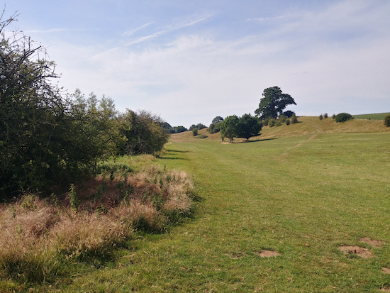
| The junction mentioned in point 6 above |
7: At this point Standon footpath 59 continues straight ahead but you need to veer to the right on Standon footpath 45, keeping the woodland on your right and the fields on your left (see image above). Head SSE then SSW with the woodland on your right and the field on your left for 720m until you come to another perfectly placed bench just before a junction in the track (location -
https://w3w.co/copper.tides.tanks).
 |
| The bench and junction mentioned in point 7 above |
8: Turn right here on Standon bridleway 41 and follow it W through the woodland for 200m before it turns diagonally to your left at the point where a private track goes off to the right (location -
https://w3w.co/ends.nets.mile), see image below. Continue SW through the woodland for another 100m until you reach a clearing with a small pond on your right. Continue SW for another 230m until you reach a bridleway T-junction just before another pond and a farm on the right (location -
https://w3w.co/tunes.global.libraries).
 |
| The footpath junction mentioned in point 8 above |
 |
| Standon bridleway 44, mentioned in point 9 below |
9: Turn left on Standon bridleway 44 and follow it SSE and ESE for 300m until you enter woodland (location -
https://w3w.co/reject.insect.giving). This is Hanging Wood. Drop down through Hanging Wood for 230m until the field opens up on your left. Continue heading ESE for 230m until you reach the lane (location -
https://w3w.co/rates.places.cats).
 |
| The path through Hanging Wood, mentioned in point 9 above |
10: Turn left on the lane and head NE for 15m before taking the track on your right. This track drops down to a ford with a footbridge alongside (location -
https://w3w.co/alive.serves.mirror). Cross the footbridge over the River Rib and continue heading SE for another 50m ignoring the first track on the right and continuing until you meet a junction (location -
https://w3w.co/marble.trim.races).
 |
| The ford and footbridge mentioned in point 10 above |
11: Here you turn left on the
Hercamlow Way and head E and NE and N for 550m to Latchford Farm (location -
https://w3w.co/square.hood.gosh). Ignore the road on the left that crosses a bridge (location -
https://w3w.co/front.this.grades).
 |
| Standon bridleway 30 mentioned in point 12 below |
12: After Latchford Farm continue along Standon bridleway 30 ignoring another ford on the left (location -
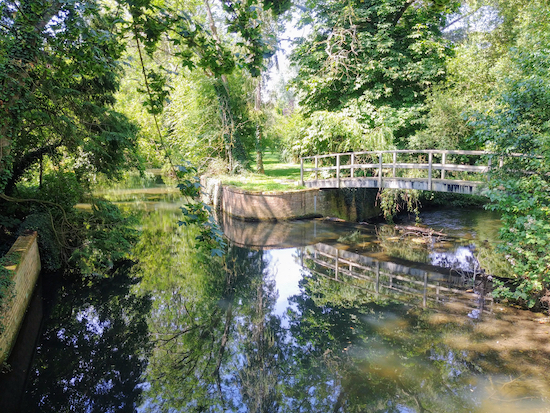
https://w3w.co/taxi.trunk.became). Keep heading N and away from the River Rib on your left for 1.6km. As you walk along this path keep looking back for wonderful views to the S. Continue until you reach Paper Mill Lane (location -
https://w3w.co/canoe.secondly.companies).
 |
| The view from the footbridge mentioned in point 12 below |
13: Turn right on Paper Mill Lane, then head E for 310m until you reach High Street, Standon (location -
https://w3w.co/freezers.mouse.blossom).
14: Turn left on High Street and head N back to the starting point.
There are two pubs and a bakery on Standon High Street. The pubs are
The Star (location -
https://w3w.co/protected.submerged.final) and
The Bell (location -
https://w3w.co/jingles.enthused.path), and
Days Bakery (location -
https://w3w.co/cubed.rhino.spaces) which is situated between the two pubs.
If you enjoyed this walk you might want to join
our friendly Facebook group where fellow walkers are sharing photographs and experiences after following our walks in the Hertfordshire countryside.
Interactive map


I attempted this walk yesterday with my daughter. It was a lovely walk with great views and varied scenery. Unfortunately we got lost somewhere around point 11 - continue heading north for 1.6km. There seemed to be several points along this stretch where we weren't sure which one to follow. Ended up using Google maps aimed towards Standon and eventually reached point 3 and were able to get back from there. Found the photos really helpful when we weren't sure about some of the instructions.
ReplyDeleteHi,
DeleteReally sorry to hear you got lost. I hope it didn't spoil your day. Glad to hear you enjoyed the views and scenery. This is one of our favourite walks.
I don't know if you or your daughter carry a smartphone but it might be worth considering downloading a free GPS app, such as Komoot. If you do you can download the GPX navigation file for this walk (I add links to these under the top map on every walk).
Then you just open it in Komoot and follow the arrow (a bit like a sat nav in the car). It's unlikely you will get lost again.
Also, if you click on the What3Word links that I add to every section it will show the exact point you need to reach (you can switch to satellite view to see the location).
Thanks for the feedback.
David
Excellent walk, with varied and interesting sections. At the end of the walk, coming into Standon along Paper Mill Lane, it is worth continuing into Standon High Street. The Parish Council have provided a short leaflet of the history of the High Street, just by the "Pudding Stone", which is most useful as you walk back to the A120. Also a proper bakery/coffee shop in Street to finish.
ReplyDeleteGreat tip. Thanks for sharing. Will try that suggestion next time we do that walk. David
ReplyDeleteThank you- another lovely walk from Hertfordshire Walker.
ReplyDeleteThe only bit of uncertainty we had was after point 11 where we had dropped down the hill and weren't sure whether to go straight across or turn right, thinking we might have reached point 13. We continued straight on across the meadow, which turned out to be the right thing to do. We always take an OS map with us so could cross reference.
Thanks again.
I am glad you enjoyed the walk. I have had a look at point 11 and added a few more What3Word references for those who use that tool. Do you use the free GPS navigation files that I add to the directions? They are a great help if used in conjunction with the directions and maps. Thanks for taking the trouble to offer feedback.
DeleteDavid
Did this walk today without realising that Standon Calling was commencing this evening. We were met by several fences surrounding the concert area. After some persuasion they agreed to let us through. A couple of points - between 12 and 13 there is a second gate not mentioned which may have confused some people as the right turn into paper Mill Lane comes after the second gate. Also the interactive map is different to the other map and instructions as it starts on the A120 and goes down Barwick Road rather than starting on the High Street and turning left onto Standon footpath 15. Also the list says walk is 6 miles rather than 5. particularly liked the parts of the walk through the woods.
ReplyDeleteWow, great feedback. Thanks Beryl. Going through your points: 1) I have added a note at the top of the walk advising walkers to check with the Standon Calling website before setting off (if they intend to do the walk in July). Apparently it's an annual music festival. I didn't know about it until you mentioned it. 2) I have moved the reference to the gate at Paper Mill Lane to avoid confusion. 3) I hadn't spotted the interactive map issue; that was a previous route for this walk (which was closer to six miles). I have fixed that. And 4), I have changed the distance in the map lists. Thanks again for this feedback, Beryl, it brill when fellow walkers help me keep the walks up-to-date. Really appreciated. David
DeleteHave done this walk a few times in the past and had a print out of the directions but now they seem to start in a different place. No problem we just followed the ones we had. We sat on the first bench you mention and had a great view but the second one at point 7 is not in very good condition and there are a lot of brambles etc in front of it. The path at No. 12 we had on the original instructions as 19 now is 30 but we found our way and I suppose we should check on older walks that everything is still the same. Very quiet again and some perfect views. Enjoyed the ups and downs and the variation and especially the walk through the Hanging Wood.
ReplyDeleteHi Deborah, yes, I updated that walk. Ellie and I often revisit walks we have published and update them with new photos and directions. Sometimes reroute them. We did that with this walk because if a parking issue. I hope it didn't spoil your day.
DeleteNo it didnt spoil anything. Lovely walk.
DeleteGood to know. :-)
Delete