5.9 miles (9.5 km) with 85m of total ascent
This walk has some great views across the north Hertfordshire countryside. It follows many well-defined tree-lined tracks and footpaths. It starts in the village of Benington where, sadly, the pub,
The Bell, has not reopened since covid. Please let us know if this changes by using the comment form beneath the directions.
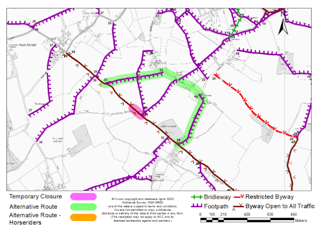
Hertfordshire County Council say that due to embankment work being carried out, Ardeley BOAT 10 / Cottered BOAT 34 (byway open to all traffic) heading S and E towards the junction with Cottered 21, for an approximate distance of 100m, will be closed for up to six months from 5 February 2024. They do suggest a diversion, please see map below.
 |
| Map courtesy of Hertfordshire County Council |
Fly through preview of walk
If you want to check what sort of landscape you will be crossing before you set off on this walk you can view a short 3D video of the route below. It's created using the free version of
Relive.
Directions
 |
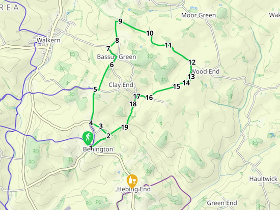
Map for Walk 102: Benington North-East Loop
Created on Map Hub by Hertfordshire Walker
Elements © Thunderforest © OpenStreetMap contributors
There is an interactive map below the directions |
Those with GPS devices can download
GPX or
KML files for this walk. We've added
What3Words location references for those who use that system. If you print these walks you might want to use the green
PrintFriendly icon at the bottom of these directions to delete elements such as photographs.
1: Park in the village of Benington, we found a spot on Church Green just outside the church (location -
https://w3w.co/glorified.wheat.striving). Head NE along Duck Lane, opposite the church and to the right of the village duck pond (location -
https://w3w.co/instead.teams.caused). Continue along Duck Lane for 500m. Just before a house on the right look out for a footpath sign on the left (location -
https://w3w.co/spearhead.massive.collects). This is Benington footpath 14.
 |
| Benington footpath 14 mentioned in point 1 above |
2: Turn left here and follow the path NW for 270m across two fields until you reach Old School Green (location -
https://w3w.co/logged.anchovies.family). Cross the lane and continue heading N for 70m towards Cabbage Green until you reach a junction in the track (location -
https://w3w.co/expectant.banquets.rounds).
 |
| The lane to Cabbage Green mentioned in point 2 above |
3: At the junction turn left on Benington footpath 6 and head SW then NW for 260m until you reach a bridleway (location -
https://w3w.co/girder.adhesive.minivans).
 |
| Benington footpath 6 mentioned in point 3 above |
4: Turn right on Benington bridleway 4 and head NNE then N for 780m until you reach the lane at Walkern Hall Farm (location -
https://w3w.co/wiping.proves.amplifier).
 |
| Benington bridleway 4 mentioned in point 4 above |
5: Turn right here and head E along the lane for 90m looking out for a bridleway on the left just past the last house on the left (location -
https://w3w.co/intruded.broadcast.zoom).
 |
| Benington bridleway 36 as it opens up and heads NE |
Turn left and take this track, Benington bridleway 36, and head NE downhill and then uphill for 680m until you reach a lane (location -
https://w3w.co/anguished.outhouse.cunning).
6: Turn left on the lane and head NE for 200m until you reach Bassus Green (location -
https://w3w.co/flukes.umbrellas.cattle). Follow the lane as it bends left and heads NW for 280m until you meet a track on the right (location -
https://w3w.co/chemistry.downfield.valid).
 |
| Walkern BOAT 29 mentioned in point 7 below |
7: Turn right here on Walkern BOAT 29 and head NE for 280m until you reach a junction in the track just before Walkern Bury Farm (location -
https://w3w.co/cropping.teachers.items).
 |
| The left turn for Walkern UCR 3 mentioned in point 8 below |
8: Turn left here on Walkern UCR 3 (an unmetalled unclassified county road) and head N for 430m until the track turns to the right and heads E for another 110m before reaching a junction in the tracks (location -
https://w3w.co/reduction.famed.drivers).
 |
| Turn right on Ardeley bridleway 9 mentioned in point 9 below |
9: Turn right here on Ardeley bridleway 9 and head SE for 740m until you reach a four-way junction (location -
https://w3w.co/sock.slim.stylists).
 |
| Ardeley BOAT 4 mentioned in point 10 below |
10: At the point where a path goes off to the left, you continue straight on Ardeley BOAT 4 and head SE, S and then E for 630m until you reach another junction in the tracks (location -
https://w3w.co/mutual.strongman.fruitcake).
 |
| Continue straight on Ardeley BOAT 4 - point 10 above |
11: Continue heading SE on Ardeley BOAT 4 for 170m until you meet a T-junction (location -
https://w3w.co/enacted.tiredness.cardinal) where you keep to the right and continue for another 540m until you reach the point where several tracks merge (location -
https://w3w.co/applied.thousands.pampering).
 |
| The T-junction mentioned in point 11 above |
12: Turn right here and head S on Ardeley BOAT 6 for 350m until you reach a bend with a beamed house ahead (location -
https://w3w.co/grounding.rectangular.romantics), see image below.
 |
| The junction mentioned in point 13 below |
13: Take the path immediately on your right, see the yellow arrow on image above. This is Ardeley footpath 30, which crosses a small field and then enters woodland.
 |
| The footpath fork mentioned in point 16 below |
After 90m you come to a fork where you take the right turn on Ardeley footpath 30 and follow it for 100m as it crosses the private drive again and heads to the right of another cottage and reaches a field (location -
https://w3w.co/prominent.dozed.stared).
14: Cross the first field and head W for 150m to the left of a tree in the distance. The path then bends to the left and continues SW for another 95m before going through a gap in the hedge (location -
https://w3w.co/stolen.dash.paving).
15: Cross another field, now on Walkern footpath 6, and head SW for 460m before crossing a third field for 230m until you meet Clay End Road (location -
https://w3w.co/qualify.tango.overtones).
 |
| Walkern BOAT 31 |
16: Turn right and head W for 300m until you reach a byway on the left (location -
https://w3w.co/museum.prowl.full). This is Walkern BOAT 31.
17: Take this byway and head SW for 200m until you reach a junction (location -
https://w3w.co/validated.melt.dolphins).
 |
| Turn right at the hedge and then left on Benington bridleway 10 |
18: Take the path to the right of the hedge keeping the field on your right and continue heading S on Walkern bridleway 9 downhill for 480m, then uphill on Benington bridleway 10 for 110m until you reach an entrance into the woodland (location -
https://w3w.co/jugs.sampling.desktop).
 |
| Turn right in the woods on Benington bridleway 10 |
19: After entering the woodland turn right on Benington bridleway 10 and follow it SW for 1km as it becomes Benington BOAT 13 and then Duck Lane before returning to the village.
Interactive map


We tried this walk recently (June 2021). I enjoyed the first half of the walk more than the second part. We got a little lost a couple of times at the point before the cottage beamed house and at the point of the cottage beamed house as it looked more like a front garden area than a route to a footpath.
ReplyDeleteThankfully the What3Words kept us on track and got us back to our car. The addition of the What3Words to the route descriptions are very helpful.
Hi,
DeleteSorry you got lost. I have added a yellow arrow to the image below point 13 in the directions to try to make it cleared. But I am glad the What3Words navigation reference helped. I hope it didn't spoil the walk.
Thanks for the feedback.
David