2 miles (3.2 km) with 50m of total ascent
 |
| The River Beane close to point 10 |
There is a free car park (at time of writing).
Fly through preview of walk
If you want to check what sort of landscape you will be crossing before you set off on this walk you can view a short 3D video of the route below. It's created using the free version of Relive.
Directions
GPX or KML files for this walk. We've added What3Words location references for those who use that system. If you print these walks you might want to use the green PrintFriendly icon at the bottom of these directions to delete elements such as photographs.
From the car park off Vicarage Lane (location - https://w3w.co/truly.tooth.shiny). You will notice two paths leading out of the car park, one to the NE and the other to the NW. Before you set off, study the map on the information board. At least half of the walk is within the Herts and Middlesex Wildlife Trusts Waterford Heath reserve.
1: Leave the car park in the NE corner (location - https://w3w.co/sudden.quite.enhancement). Follow the path through the woods then out to North Heath.
Head NNW across North Heath for 225m until you reach a fork in the track (location - https://w3w.co/riders.agrees.cool), see image below.
 |
| Leave the main track by taking the left fork |
 |
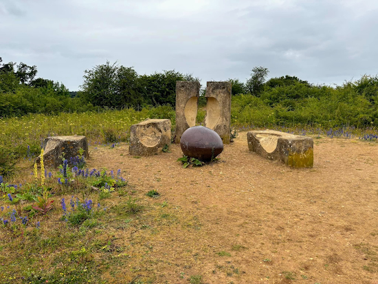
| 'Breaking the Mould' is a sculpture by Andrew Mckeown Image courtesy of Gayle Webster |
"It takes the form of a giant seed, which has emerged, from an industrial mould. The mould is old and has been broken. The sculpture represents new life and growth emerging from industrial decline. The six piece cast stone and iron sculpture was installed as a 'Marker' for each of the 21 Changing Places regeneration sites across England and Wales. The sculpture celebrates and marks the £60 million Changing Places programme which transformed 1,000 hectares of post-industrial derelict land into parks and open spaces."After viewing the sculpture head NE downhill for 55m to rejoin the main track (location - https://w3w.co/shiny.usual.little) then head in a northerly direction for 125m until you reach a gate (location - https://w3w.co/fried.enjoy.stud), see image below.
 |
| Follow the path down to the River Beane |
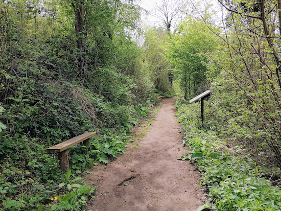
4: Turn left on Stapleford footpath 2 then walk SSW alongside the River Beane. There is a bench on the left about 20m after turning left, see image below.
 |
| Bench along Stapleford footpath 2 Image courtesy of Gerry Gross |
 |
| Continue alongside the River Beane and under the railway |
6: Continue heading S until you reach Vicarage Lane (location - https://w3w.co/doing.sand.remedy).
7: Turn right on Vicarage Lane then head W for 60m until you reach a path on the left before the River Beane (location - https://w3w.co/rang.hooks.cried).
8: Turn left, still Stapleford footpath 2, then follow it as it heads S alongside the river for 200m until you reach a fork in the path (location - https://w3w.co/vows.chin.vets).
 |
| Looking back along the River Beane - continue with the river on your right |
 |
| Turn left at the marker then follow the black arrow signs |
11: When you reach a footpath T-junction turn left, still on Hertford footpath 24, then head NE looking out for a marker post with yellow and black arrows. Turn left then follow the path as it bends round to the right then continue to South Heath.
 |
| At the top of the hill, turn left and follow the black arrow signs |
Getting to the car park
We recommend you approach the car park on Vicarage Lane from the east and not the west. If you approach from the west the lane is narrow with few passing places and there is a sharp bend over the railway bridge where we got trapped in a traffic jam caused by an articulated truck getting stuck. It took half an hour to clear.
A local resident told us it is far better to approach the car park via Bulls Mill Lane, Sacombe Road, then Vicarage Lane. They were right. We rerouted that way.
Unlike most of our walks, this route doesn't pass close to a pub or a cafe, so take refreshments with you. There is an elevated picnic table three quarters of the way round affording great views. The nearest places to find refreshments are in Bengeo which is about a mile to the south of the start and finish point by road. They are The Greyhound (location - https://w3w.co/helps.blunt.calculating), The White Lion (location - https://w3w.co/golf.cabin.thick), and The Secret Garden cafe (location - https://w3w.co/define.knots.gift).
The starting point is two miles N from Hertford North station by road. We have another walk in this area. It's Walk 203: Waterford Heath South-West Loop.


I really wonderfull well thought out walk. The autumn colours are on their way and the last summer rays were on us today. There are some fantastic views as well as magical little woodland and river paths. There really is a great deal to love about this walk and an introduction to an area that is ripe for future exploring. Thank you. Daniel, Iwona, Sara and Casper.
ReplyDeleteHi Daniel, Iwona, Sara and Casper,
ReplyDeleteGlad you enjoyed it. Ellie and I did, too. We wondered whether it was too short to add to the collection, but the mix of landscapes in such a compact area convinced us that it's a good addition, especially for those who may not be able to walk too far.
David
Enjoyed this walk. Quite a hill towards the end but luckily was in the shade.
ReplyDeleteYes, quite a climb, hope you enjoyed it.
DeleteWell what was supposed to be a short walk between showers turned into something else. At point 7 where you walk through Arch under railway line entrance is totally flooded/impossible . Therefore walked south down North Road left onto High Molewood and rejoined route at point 9 . Still enjoyed it and missed the rain . In case other walkers are thinking of this route now . Still missed the showers and thanks. Ian R .
ReplyDeleteWow, never known that to be flooded to the point of being impassable. Well done figuring out a workaround. Dave
Delete