4.7 miles (7.64 km) with 83m total ascent
 |
Update July 2021: Tarmac has announced that parking charges will be introduced at Panshanger Park's Thieves Lane car park from 15 July 2021. The day rate for parking will be £2.50 and will initially be charged Thursday to Monday between 8:30am and 5:30pm. The company says assistant park rangers will be equipped with card machines and payment will be by card only. Payment by cash will not be accepted.
Directions
 |
| Map for Walk 80: Panshanger Park Long Loop Created on Map Hub by Hertfordshire Walker Elements © Thunderforest © OpenStreetMap contributors There is an interactive map below these directions |
 |
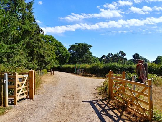
| The gate leading out of the car park at the start of the walk Photograph courtesy of Greg Readings |
When you reach the hedgerow go through another gate then turn right, still on Hertingfordbury footpath 32, and head SW for 240m. You will cross two wooden footbridges before crossing a larger bridge over the River Mimram. If you pause on the bridge and peer into the water you might spot crayfish. After crossing the bridge turn right (location - https://w3w.co/shadow.clubs.money). Do not go under the underpass on your left.
2: After turning right on Hertingfordbury footpath 33 you will come to a fork in the path. Take the right-hand fork by going through a gap to the right of the gate (location - https://w3w.co/smile.same.idea), see image below.
 |
| Go through the gap to the right of the gate Photograph courtesy of Greg Readings |
3: At this point take the track on your left then head S uphill for 160m into the woodland.
4: At the top of the hill turn right (location - https://w3w.co/dangerously.calls.rested) then follow the track first W and then NW for 680m as it meanders through some stunningly beautiful, unspoilt woodland. Continue until you reach a fork in the track (location - https://w3w.co/vague.boost.woods), see image below.
 |
| Take the left-hand fork then head S before turning right and heading NW |
6: At the bottom of the hill (location - https://w3w.co/basket.taking.harder) turn right and follow the path round to your right as it heads ENE then SE for 980m until you reach Kings Lake (location - https://w3w.co/lawn.dark.forks).
7: Turn left at Kings Lake and walk NE with the lake on your right and continue for 220m until you reach a gate signposted Oak Trail (location - https://w3w.co/firm.thus.pulse).
 |
| Go through the gate to the Oak Trail and head diagonally NW across the field |
9: When you reach the next gate take the left fork and continue heading NW. Soon after going through this gate look out for a track that veers slightly to your left and drops through the hedgerow to a 19th century water wheel and Repton's Broadwater - see image below (location - https://w3w.co/acted.ideal.storms).
 |
| The 19th century water wheel at Repton's Broadwater |
10: Here you will find a bench with great views; you might just need it at this point. After a sit down turn left a short distance and then turn right (location - https://w3w.co/poet.soup.lawn) into the woodland following the Oak Trail up to a large oak tree surrounded by a metal fence (location - https://w3w.co/cure.less.parade).
11: When you reach the oak consider taking time to admire this wonderful specimen. A couple of benches have been placed around the site for those wanting to just stop and take in the historical significance of this tree. It's estimated to be between 450 and 500 years old, and is thought to have been planted by Queen Elizabeth I. It's said to be the largest 'maiden' or clear-stemmed oak in the country.
 |
| The largest clear-stemmed oak in the country - 450 and 500 years old |
 |
| Information board about the Panshanger Oak |
 |
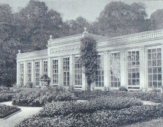
| The remains of the Orangery in Panshanger Park |
 |
| The Orangery in Panshanger Park in 1895 |
 |
| A photograph displayed at the site |
 |
| The view to the S from where Panshanger House would have stood |
 |
| Go through the gate to the right of the site of Panshanger House |
 |
| Turn right past the large wooden bird and head SE along a permissive path |
 |
| The permissive path follows the track E and SE through woodland |
 |
| Continue following the track as it heads E and SE back to the car park |
Panshanger Park is a 1,000 acre site owned by Tarmac and managed by Herts County Council and the Herts and Middlesex Wildlife Trust for the benefit of both people and wildlife.
Interactive map
A brief history of Panshanger Park
(Text from the Herts and Middlesex Wildlife Trust website)
"Owned by the Cowper family from the late 17th century to the early 20th century, the Panshanger Estate was shaped around the Mimram Valley following advice from Humphry Repton and Lancelot 'Capability' Brown. Panshanger Park is registered as a Grade: II* park and garden by Historic England.
More recently since the 1980s, the park has been owned by Tarmac and parts have been quarried for sand and gravel. Much of the site has now been restored to arable farming and a range of valuable wildlife habitats including a new section of chalk river and a number of lakes. The park opened to the public on 31 March 2014 and comprises a country park and nature reserve. More of the site will be opened up in a series of carefully managed phases as the remaining extraction processes on site come to an end."
Hi David not walked this route for a while still a lovely walk with a bit of everything . North of point 16 they’re planting 17,000 trees to be called Queens Wood a very nice thought . Thanks Again. Ian R .
ReplyDeleteHi Ian, a lovely spot. I didn't know about the trees. Thanks for the info. David
DeleteDid this walk today with 2 of my grandchildren- good to mix up field trails, woods, lakesides though we took a short cut from 8- 14 as it was pretty warm and they were beginning to tire and we didn’t want to encounter the cows, though I think we could have stayed well clear of them. Still managed over 4 miles and the views are lovely and the wooden sculpture at Queens Wood is lovely! We could hear birds of prey, saw pretty dragonflies, Canada geese, ducks and squirrels 😊
ReplyDeleteGlad you enjoyed it. We love waking there. I like stopping to watch the birds on a bench close to point 7.
Delete