3.5 miles (5.7 km) with 55m of total ascent
 |
| The path across North Mymms Park to Tollgate Road |
Directions
 |
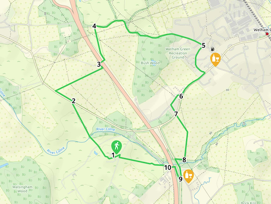
| Map for Walk 74: North Mymms North-East Loop Created on Map Hub by Hertfordshire Walker Elements © Thunderforest © OpenStreetMap contributors There is an interactive map below these directions |
Park near St Mary's Church North Mymms or on St Mary's Church Road (location - https://w3w.co/lung.atoms.scope).
1: Walk through the churchyard and past the left side of the church then turn slightly to the right looking out for a path on the left leading NW down to two gates (location - https://w3w.co/branded.bleak.assets).
Take this path, North Mymms footpath 29 and continue heading NW. The path crosses the drive into North Mymms Park and enters another field. Cross this field still heading NW until you reach a footbridge over the River Colne (location - https://w3w.co/drape.elaborate.frost).
 |
| Take the wooden footbridge over the River Colne |
 |
| Follow the way markers as you walk NW through North Mymms Park |
 |
| Turn left after the gate and head NW |
 |
| A line of trees and markers indicate the route NE across the fields |
Cross the bridge and turn left on the other side , still on North Mymms footpath 52, and head N for 350m until you reach the old Dellsome Lane (location - https://w3w.co/losses.puddles.deed).
4: Turn right on Dellsome Lane, still North Mymms footpath 52, and follow it round to your right and head E and SE for 1km until you reach the houses in Welham Green (location - https://w3w.co/suffer.normal.modes).
 |
| Follow Dellsome Lane S and SE to Welham Green |
6: When you reach Dixons Hill Close (location - https://w3w.co/kite.jolly.money), turn right and follow the road round to the left looking out for a footpath on your left (location - https://w3w.co/horns.tried.people). Take this path, North Mymms footpath 31, and head SSE for 100m to Dixons Hill Road (location - https://w3w.co/union.fear.agents).
7: When you reach Dixons Hill Road you will see North Mymms footpath 31 continues almost immediately opposite. Follow this footpath SSE across the fields for 210m before it turns SSW and continues for another 280m until you reach a footpath junction (location - https://w3w.co/thigh.trim.doctor).
 |
| The footpath from Dixons Hill Road to Water End |
9: After 190m you will reach the top of Warrengate Road, look out for the bridleway sign on the opposite side of Swanland Road (location - https://w3w.co/foam.calm.fresh). This bridleway, North Mymms bridleway 82 goes over a footbridge above the A1(M). Take this bridleway which heads N then W over the bridge.
10: At the other side of the bridge look out for a footpath on your left (location - https://w3w.co/extra.riches.slide), this is North Mymms footpath 6. Go through a gate, and then turn diagonally to your right walking ENE back to St Mary's Church.


No comments:
Post a Comment
Comments and feedback
If you try any of the walks on this site, please let us know what you thought of them by adding a comment here or on our members-only Facebook group. Comments here are checked before they are published. Comments on the Facebook group go live immediately.