2.2 miles (3.5 km) with 54m total ascent
 |
| Little Berkhamsted bridleway 17 mentioned at point 4 |
This is an excellent walk which includes a spectacular stretch of bridleway, a sandy path edged in gorse, and rich woodland. Don't be put off by the golf course and quarry along the way, you are soon past them. You will follow a picturesque and well-worn path linking Howe Green and Little Berkhamsted,with oak trees that must be hundreds of years old.
Getting there
There are bus stops close to the start of the walk (location -
https://w3w.co/tolls.basic.eagles)which are served by the number 38 bus. You can check bus times at
Intalink.
At the time of writing there is free parking in a layby outside Little Berkhamsted Cricket Club opposite the
Five Horseshoes pub (location -
https://w3w.co/spine.starts.bikes).
Emmie Murphy's village store at the start/finish point serves hot drinks and snacks.
Fly through preview of walk
If you want to check what sort of landscape you will be crossing before you set off on this walk you can view a short 3D video of the route below. It's created using the free version of Relive.
Directions
 |
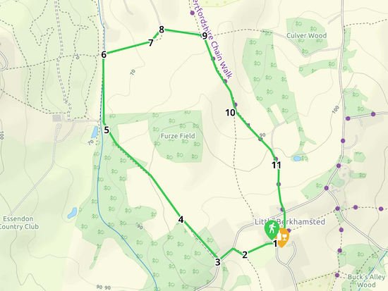
Map for Walk 7: The Little Berkhamsted North-West Loop
Click on the map above for a larger version
Created on Map Hub by Hertfordshire Walker
Elements © Thunderforest © OpenStreetMap contributors
There is an interactive map at the foot of the page |
Those with GPS devices can download
GPX or
KML files for this walk. We've added
What3Words references for those who use that system. If you print these walks you might want to use the green
PrintFriendly icon at the bottom of these directions to delete elements.
 |
| Enter the cricket field by the gate near the shops |
1: Enter the cricket field by the gate near the shops at the NE end of the ground (location -
https://w3w.co/plots.driver.times). Follow the footpath, Little Berkhamsted footpath 8, for 170m heading WSW keeping the hedge on your right and the cricket field on your left, until you reach a gate in the corner of the field (location -
https://w3w.co/filer.apples.twin), see image below.
 |
| Turn right here on Little Berkhamsted bridleway 22 |
2: Turn right here on Little Berkhamsted bridleway 22, then head NW for 70m until you reach Little Berkhamsted Lane (location -
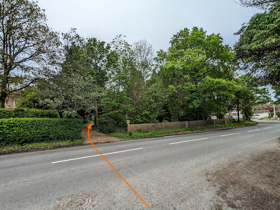
https://w3w.co/influencing.seat.twist). Turn left and head SW for 90m until you reach a bridleway on your right (location -
https://w3w.co/amber.soon.strict), see image below.
 |
| Turn right on Little Berkhamsted bridleway 17 |
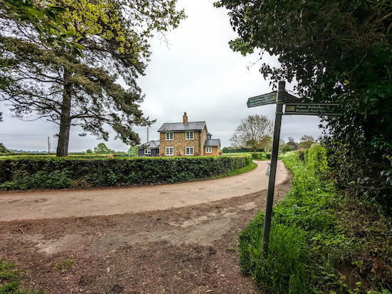
3: Turn right on Little Berkhamsted bridleway 17 then head NW. After 290m you reach Danes Farm (location -
https://w3w.co/games.enjoy.liner). At this point the bridleway becomes a track, see image below.
 |
| Continue heading NW on Little Berkhamsted bridleway 17 |
4: Continue heading NW Little Berkhamsted bridleway for 430m with good views to the left across to Bedwell Park. There are gorse bushes on the left and right along with views N across the Lea Valley. The bridleway then drops down through woodland. At this point it can be quite muddy after rain.
At the bottom of this hill you pass a cottage on your left and an outbuilding on your right as the bridleway veers slightly to the left before reaching a gate leading to the golf club (location -
https://w3w.co/guilty.noise.mason), see image below. Ignore a track on the right leading to a driving range.
 |
| Turn right on Essendon bridleway 25 |
5: Cross a small stream then turn right on Essendon bridleway 25 (location -
https://w3w.co/glory.soil.ages). Walk N for 340m with the conifer trees on your left and hawthorn on your right until you reach a junction (location -
https://w3w.co/yard.zeal.holds), see image below.
 |
| Turn right on Little Berkhamsted bridleway 2 |
6: Turn right on Little Berkhamsted bridleway 2. Cross a small stream (this is marked as a ford on some maps). Keeping the quarry on your left, climb ENE up the sandy bridleway for 250m to the top of the hill.
7: Here you will come to a fork in the path, with a step stile to your left (location -
https://w3w.co/after.rift.mixed) and a bridleway continuing straight. You can go either way as both meet again soon after at a gate leading into a lane (location -
https://w3w.co/piles.left.discrepancy).
 |
| When you reach the lane, turn right and follow the lane ESE |
8: When you reach the lane, turn right and follow the lane ESE for 230m round past Ashfield House on the left and Ashfield Cottage on the right, until the lane ends at a farmyard (location -
https://w3w.co/tile.only.flash), see image below.
 |
| Turn right on Little Berkhamsted bridleway 18 |
9: Take the bridleway on your right at the end of the lane, Little Berkhamsted bridleway 18, then head slightly uphill keeping the farm on your right. Continue on Little Berkhamsted bridleway 18 heading uphill and SSE for 400m until you reach a concrete footbridge (location -
https://w3w.co/gentle.softly.fingernails), see image below.
 |
| After the bridge turn left on Little Berkhamsted bridleway 19 |
10: After the bridge turn left then climb the hill now on Little Berkhamsted bridleway 19, see image below.
 |
| Climb the hill on Little Berkhamsted bridleway 19 |
Continue heading SE for 300m until you reach Breach Lane (location -
https://w3w.co/festivity.nerve.merit), see image below.
 |
| Turn right on Breach Lane |
11: Turn right on Breach Lane and follow the lane S for 300m back to the village. You will reach Robins Nest Hill (location -
https://w3w.co/beams.friday.meals) where you cross the road and take the path through the churchyard back to Little Berkhamsted village centre where you turn left to return to the starting point, see image below.
 |
| Take the path through the churchyard back to the starting point |
Interactive Map


Had an enjoyable Christmas day walk with friends and their two Ridgebacks, directions were all perfect and easy to flow as always. A bit of a grey day but still some nice views but will come back in better weather for photos.
ReplyDeleteHi Jason, Carole & Fred, glad you enjoyed that walk. It's one of our go-to walks because it's close to where we live. If you haven't already done so please consider joining our Hertfordshire Walker Facebook group where fellow walkers are sharing photos and reports from their walks.
Deletehttps://www.facebook.com/groups/hertfordshirewalker
I would strongly advise against the alternative route across the field at the end of this walk. You come out onto Robins Nest Hill which is a busy road with some blind bends and areas with no verge. We felt very unsafe walking on this road (over half a mile) and even got repeatedly honked by impatient car drivers
ReplyDeleteHi, thanks for the feedback. The option I suggested in the directions was to explore the field down to the woods, which is a site of special scientific interest and has some wonderful wildflowers in the spring and summer. The option didn't suggest carrying on to Robins Nest Hill then walking more than 1km on a dangerous busy road. We would never recommend walkers do that. You will have noticed that there was no mention of walking along Robins Nest Hill in the directions, and the GPX file clearly shows the proper routes along some lovely bridleways and footpath that are traffic free. However I have removed the option from the directions. Sorry you had such a bad experience. I recommend you try the walk again and follow the route as set out in the directions. It is a lovely walk. :-) David
Delete