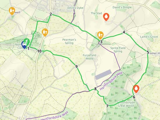
5.6 miles (9 km) with 104m total ascent
 |
| One of the old byways along the route |
There is one pub along the way, the John Bunyan at Coleman Green, and another, the Elephant & Castle at Amwell, which is 900m from the start/finish point (location - https://w3w.co/answer.shock.season). You pass the '3 Brewers' brewery along the way.
There is a cafe at West End Barns Cafe, Nomansland 910m west of the start/finish point (location - https://w3w.co/nearly.impact.diary).
Directions
 |
| Walk 54: Symondshyde Loop Created on Map Hub by Hertfordshire Walker Elements © Thunderforest © OpenStreetMap contributors There is an interactive map embedded at the end of these directions |
Park in the car park south of Ferrers Lane along Nomansland Common (location - https://w3w.co/tests.staple.scars).
Because the first 500m of the walk is following tracks through woodland that is part of the common and which have no signposts, we have set out more detailed stages than usual for this short section at the start of the walk.
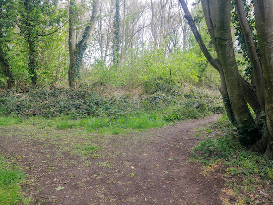
1: Take the path E out of the car park (location - https://w3w.co/friend.monks.music), cross Ferrers Lane, and take the footpath on your right (location - https://w3w.co/shout.slam.limes) and head ENE for 40m until you reach a path going off to your left (see image below).
 |
| Head N between the two trees |
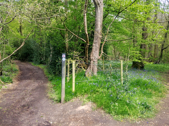
Turn left on this path (location - https://w3w.co/spared.swan.pays) and head N for 20m walking between two trees (see image above). After passing between the two trees follow the path to your left for 30m until you reach a fork in the path (see image below).
 |
| Take the right fork and head N through the woods |
 |
| The woodland leading to Down Green Lane |
Head N along the lane, with the houses on your left, for 130m until you reach a footpath leading into the woods (location - https://w3w.co/bright.passes.fires).
 |
| The right-hand turn mentioned below |
 |
| The left-hand turn mentioned below |
At this point you will reach Wheathampstead footpath 82 which you follow N for 230m with the hedgerow on your left and the field on your right until you reach woodland.
Here you turn right (location - https://w3w.co/adjust.settle.minute) walking E for 260m with the woods on your left and the field on your right until you reach a footpath junction (location - https://w3w.co/jeeps.sleepy.kicks).
Turn left and follow Wheathampstead footpath 48A NNE for 220m with the woods on your left and the road on your right and continue until you reach Hill Dyke Road on your right.
2: Turn right and cross The B651 looking out for Wheathampstead footpath 74 on the right at the junction of Hill Dyke Road and the B651 (location - https://w3w.co/sizes.toast.trying). Take this footpath and head ESE for 540m at first with the hedgerow on your left and the field on your right until you reach Dyke Lane (location - https://w3w.co/chins.firm.flash).
Cross Dyke Lane then take Wheathampstead footpath 22 and head ESE for 100m at which point the path becomes Sandridge footpath 16 which you follow ESE for 290m until you reach a lane. Turn right then take the footpath on your left as the lane bend to the right (location - https://w3w.co/cases.eating.wisely), see image below.
 |
| Go round the metal gate then through the wooden gate |
* As you walk this path look to your left and you will see some farm buildings 500m to the NE. This is the Farr Brewery (location - https://w3w.co/values.cried.leave) which organises tours and tastings. We went on one before lockdown and it was great. The brewery is open every Friday and Saturday 11-5 to collect.
Continue on Sandridge footpath 13 until you arrive at the John Bunyan pub/restaurant on Coleman Green Lane (location - https://w3w.co/upset.worker.reader).
3: From the John Bunyan pub turn left and walk NE for 60m looking out for a byway sign across the lane on your right by John Bunyan's Chimney (location - https://w3w.co/call.cure.nails). The monument is all that is left of the cottage where Bunyan is said to have stayed and preached.
This track is a BOAT (byway open to all traffic). And for the length you will walk it is both Wheathampstead BOAT 3 and Hatfield BOAT 57, suggesting that this old byway follows a parish boundary.
Head along this byway, which is an excellent example of a Hertfordshire holloway, also known as a sunken lane. Continue heading NE for 600m, until you reach a set of steps on your right leading to a footpath (location - https://w3w.co/melt.risk.dishes), see image below.
 |
| The steps leading to Hatfield footpath 53 |
Head SE along this path for 590m ignoring a track to your right and continuing until you reach a house on the left at the point where the path becomes a metalled track. Continue heading SE for 170m until you reach a five-way junction (location - https://w3w.co/park.treat.sake).
5: Take the second bridleway on your right, Hatfield bridleway 49, see image below, and continue with the hedge on your right and the field on your left.
 |
| Take Hatfield bridleway 49 to the left of the hedge |
 |
| The bluebells between points 5 and 6 |
* At this junction you might notice the entrance to the Three Brewers brewery on your left. They have a collection service for lovers of real ale who want to pick up their beer direct from the brewery and have a bar open on certain days, see images below.
.jpeg) |
| The 3 Brewers Brewery |
.jpeg) |
| Opening hours at 3 Brewers Brewery (April 2024) |
Take this track, Hatfield bridleway 47, see image below, and head WSW for 460m through Symondshyde Great Wood until you reach a bridleway T-junction (location - https://w3w.co/lion.trucks.card).
 |
| Bridleway 47 heading into Symondshyde Great Wood |
 |
| Sandridge restricted byway 1 on the western edge of Symondshyde Great Wood |
 |
| Sandridge bridleway 7 heading NNW off Hammonds Lane |
9: Cross Coleman Green Lane and head NW then WNW, then W, still on Sandridge bridleway 7, for 1km until you reach the B651 (location - https://w3w.co/remedy.friend.elbow).
10: Cross the road and head W along the northern edge of Ferrers Lane for 320m until you reach the path back to the car park.


Really enjoyed this varied walk today. Slight confusion: when you download the embedded GPX file it takes you to the old route map and the starting point at the pub! Otherwise directions v clear and photos helped, thanks!
ReplyDeleteHi Jackie, thanks for pointing that out. Not sure what went wrong there. I did check it at the time I created the folder, but we did reroute this walk and something seems to have gone wrong since the update.
DeleteAnyway I have fixed it, I think.
Would you mind refreshing the page and trying to download the GPX file again to see if it opens with the new route that starts and finishes in the car park off Ferres Lane, Nomansland Common, please? It worked for me with the new route just now when I tested.
Thanks for taking the time to let me know. Appreciated.
:-)
David
Thanks David, just tried it again and all now fixed - it loads the new route and start point. Such an enjoyable walk - we'll be doing it again and hopefully stopping for a pint at the 'John Bunyan' when open :)
DeleteThanks Jackie.
DeleteWe used to do the previous shorter version of this walk and it was always difficult to park. We tried this extended walk at the weekend and it is a good addition and easier to park. A bit tricky to find your way through the woods but the rest of it is very clear and you get some lovely views over open countryside.
ReplyDeleteGreat glad you liked it. The bit through the woods is tricky, and also hard to describe when writing the directions. I relied a lot on distances, compass points, photos, and What3Word references. That section could really do with a few marker posts and signs. But glad you found your way through. The GPS navigation files are always worth downloading if you have a smartphone. They track the exact route. Thanks for the feedback.
ReplyDeleteDavid
Yes we always use the GPS navigation files now. Very helpful.
ReplyDeleteGood to know. There are some sections/junctions on walks that are just so hard to describe, especially deep in woodland and under the canopy. I am so glad one of the regular users of the site recommended adding GPS navigation files. I always test them using my OS app and Komoot to make sure they work.
DeleteDavid
I did this walk yesterday and really enjoyed it. Nice mix of fields and woodlands. Not too many other walkers around despite good weather, so it felt very peaceful. A few difficult muddy patches on the route but we managed to get around them. Quality walking boots are a must! The GPX file made it really easy to put into our GPS. Will do this walk again and looking forward to doing other walks from this great website. Thanks.
ReplyDeleteSo glad you enjoyed it, despite the mud. And nice to know the GPX helped. Thanks for the feedback. David
DeleteI tried this walk today after find your website last night. I'm new to Hertfordshire and have been missing walks I know or getting good routes from friends but this was wonderful! I even saw a hawk hovering right above me and got in some drawing practice at Bunyan's chimney! Thank you!
ReplyDeleteGreat to hear. Welcome to Hertfordshire. So glad you found our site. And thanks for posting such great feedback. If you are on Facebook please consider joining our friendly Hertfordshire Walker Facebook group where fellow walkers are sharing their walking experience and photos. Everyone is welcome. :-)
Deletehttps://www.facebook.com/groups/hertfordshirewalker