3.7 miles (5.85 km) with 60m total ascent
 |
| Poppies between points 2 & 3 in the walk |
An undulating walk through farmland and woodland with the option of refreshments at
The Grandison in Bramfield at the start, finish. There are some good wide paths for most of the way, and, if you are walking in June or July look out for the poppies between points 3 and 4 in the directions below. If you are walking in the winter it can be muddy, especially leading up to point 4 and leading up to point 7. The starting point for the walk is 2.7 miles NW of Hertford North Station by road.
Fly through preview of walk
If you want to check what sort of landscape you will be crossing before you set off on this walk you can view a short 3D video of the route below. It's created using the free version of Relive.
Directions
 |
Walk 44: Bramfield Loop
Click on the map for a larger version
Map created on Map Hub by Hertfordshire Walker
Elements © Thunderforest © OpenStreetMap contributors
There is an interactive map embedded at the end of these directions |
Those with GPS devices can download
GPX or
KML files for this walk. We've added
What3Words location references for those who use that system. If you print these walks you might want to use the green
PrintFriendly icon at the bottom of these directions to delete elements such as photographs.
1: Park in the village of Bramfield (location -
https://w3w.co/middle.festivity.motion). There are many options along the main road through the village which is called Winding Shott. Please check for any parking restrictions. There were none when we tested this walk.
 |
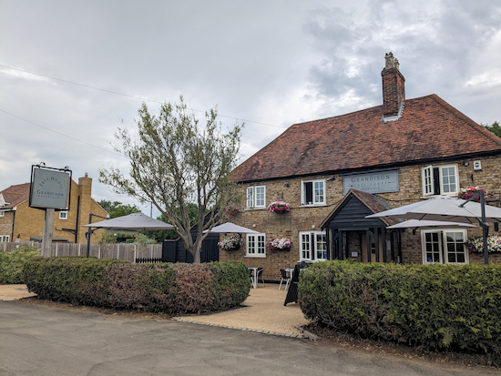
| The Grandison on Bury Lane, Bramfield |
Head W down Bury Lane (location -
https://w3w.co/lowest.cars.groups), which is also Bramfield
footpath 7. You will pass
The Grandison on the right (location -
https://w3w.co/danger.rabble.gifts) and continue heading W then SW for 660m until you reach a gate, and a footpath on the left (location -
https://w3w.co/aspect.fleet.woes), see image below.
 |
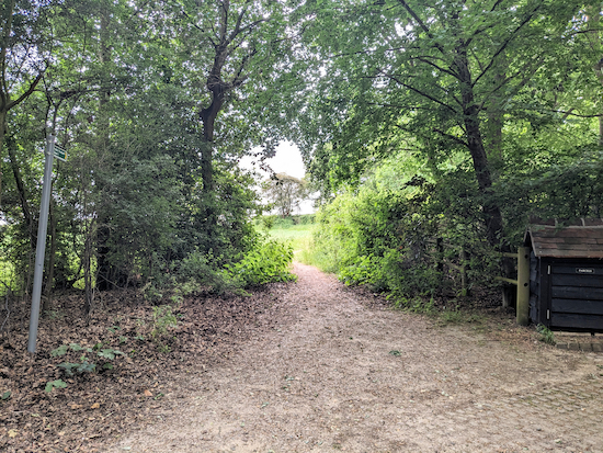
| Turn left immediately before the gate still on Bramfield footpath 7 |
2: Here Bramfield footpath 7 turns left then heads S, with the hedge on the right and the field on the left, for 75m before going through a gap on the right (location -
https://w3w.co/stable.visits.adopt), see image below.
 |
| Continue heading SW with the hedgerow on the right and field on the left |
Bramfield footpath 7 then continues round the southern edge of Bramfield Bury Park, with the hedgerow on the right and field on the left for 780m until it meets a junction in the tracks (location -
https://w3w.co/bless.sample.toxic), see image below.
 |
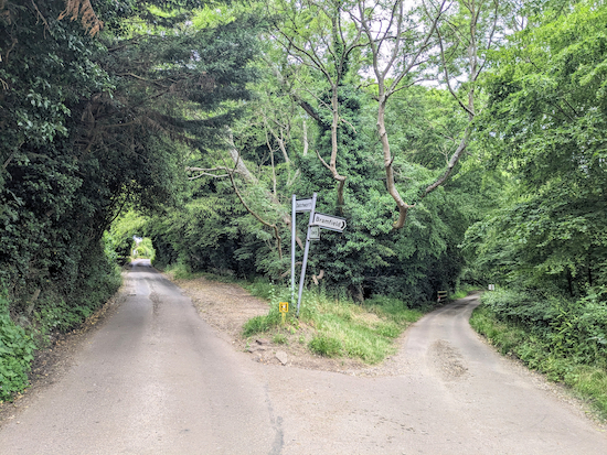
| Turn right on Bramfield bridleway 3 |
3: Turn right on Bramfield
bridleway 3 then follow the track first NW for 95m then NNW for 100m before the bridleway branches to the right at a fork (location -
https://w3w.co/icon.shops.began), see image below.
 |
| Ellie showing where Bramfield bridleway 3 forks right and N |
Continue on Bramfield bridleway 3 as it heads N then NNE for 705m until it leaves the woodland (location -
https://w3w.co/flats.myself.branded), see image below.
 |
| Head NW and uphill with fields either side |
Continue, now on Tewin bridleway 40, heading NW and uphill with fields either side for 490m until you reach Tewin Lane (location -
https://w3w.co/flags.sleep.often). Turn right on Tewin Lane then head N for 65m until the road forks (location -
https://w3w.co/scam.ruby.cult), see image below.
 |
| Keep right and stay on Tewin Lane |
4: Keep right and stay on Tewin Lane then follow it NNE for 490m until you reach a T-junction with a road called Winding Shott (location -
https://w3w.co/yours.foal.bright), see image below.
 |
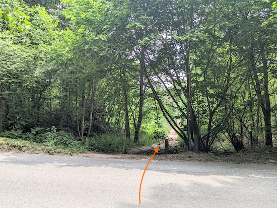
| Cross Winding Shott then head NW along the bridleway opposite |
5: Cross Winding Shott then head NW along Bramfield bridleway 1 for 460m until you reach a junction in the track (location -
https://w3w.co/jolly.crush.tapes), see image below the map.
* John Bevan, a regular user of Hertfordshire Walker, suggested a short detour at this point - particularly when the bluebells are out. John wrote: "From point 6 you can take a short diversion through one of the most beautiful bluebell woods in the county. Head NE for 900m along Perrywood Lane with views over the fields towards Watton and Stapleford. Read the estate notices about conservation of the ancient hornbeams you are passing, then turn left (location - https://w3w.co/bunks.spits.baked) and back through the bluebell wood to point 6." We have included a map of John's suggested detour below. Thanks for the suggestion, John.
 |
| The detour, in orange, to visit the bluebell wood |
 |
| Turn right, still on Bramfield bridleway 1 |
6: If you don't take John's detour, turn right, still on Bramfield bridleway 1, then head ESE the SE crossing two junctions and ignoring footpaths off to the right and left. Continuing for 1.1km to a fork (location -
https://w3w.co/caller.insist.coast), see image below.
 |
| Keep right at the fork, still on Bramfield bridleway 1 |
Keep right at the fork, still on Bramfield bridleway 1, then head S for 450m until you reach Winding Shott (location -
https://w3w.co/sung.canny.chip), see image below.
 |
| Turn left on Winding Shott then follow it back to the starting point |
7: Turn left on Winding Shott and follow it SE then S for 340m back to the village and the starting point.
Interactive map


Really nice walk. As you get to point 4 (before you turn onto Tewin Hill) there is a lovely Tea Room. Perfect for a half way stop, seating inside and out, nice selection of Sandwiches, Hot Sausage Rolls, Drinks, Cakes and other bits to enjoy.
ReplyDeleteThanks for that information, Darren. Do you remember the name of the tearoom? I didn't know there was one there.
DeleteDavid
I didn't find this either. Whereabouts exactly please.
DeleteThe cafe is Country Bumpkin, on Tewin Hill walking towards Tewin. Great place, checkbopening times
DeleteGreat, thanks for the tip.
DeleteMy husband and I did this walk last Saturday and thoroughly enjoyed it - a good variety of paths, walking along fields, skirting the edges of woodland and winding through the woods as well. Bramfield is a great start and finish point, and we discovered The Grandison pub, which has great food and is friendly to walkers. We even met a fellow rambler en route and walked together up to Queen Hoo house. We hope to do this walk again in the late spring, as it was very muddy, and extend it into a figure of eight by connecting with Watton at Stone via the numerous paths and bridleways. This will give us a full day's walking, in a lovely part of the Herts countryside.
ReplyDeleteHi Mary,
ReplyDeleteThanks for the feedback. Glad you enjoyed it. And yes, it's a good base for walking, we like that area too. If you want to link it to another walk to Watton at Stone perhaps you could merge it with Walk 43 The Datchworth Loop. https://www.hertfordshirewalker.uk/2018/01/walk-43-datchworth-loop.html
David
Thoroughly enjoyed this walk, I must say, I definitely have a soft spot for rolling countryside and woodland walk and this route had both. No nasty hills which, for me, was good. We parked in the little carpark at the top of Bury Lane, and at the end of our walk, cut across the field to visit the churchyard.
ReplyDeleteYes, that is a nice walk. Glad you enjoyed it. There are some nice stretches through woodland. I have never tried that route across the field to the churchyard. We might try that the next time we do that walk.
DeleteWe have done this walk 3 times now
ReplyDeleteLots of competition but is 1 of our favourites
There is a car park at Tewin tennis courts at the Tewin end of Tewin Hill. If worried about parking you could start here, walk up Tewin Hill and join the walk at point 4. This would take you past the Country Bumpkin mentionned above, and include the Plume of Feathers as another possible place to stop.
ReplyDeleteThanks for the tip.
Delete