2.9 miles (4.7 km) with 22m total ascent
 |
| The footbridge mentioned at point 10 |
A gentle circular walk from
Brookmans Park Station to Water End and back. There is a pub called
Brookmans at the start and finish, and
The Woodman Inn at the halfway point. There are also cafes, restaurants, and shops in Brookmans Park. About a third of the walk is along lanes so if you have dogs or children you might want to pick another route.
Fly through preview of walk
If you want to check what sort of landscape you will be crossing before you set off on this walk you can view a short 3D video of the route below. It's created using the free version of
Relive.
Directions
 |
Map for Walk 3: The Water End Loop
Click here or on the map above for a larger version
Created on Map Hub by Hertfordshire Walker
Elements © Thunderforest © OpenStreetMap contributors
There is an interactive map below the directions |
Those with GPS devices can download
GPX or
KML files for this walk. We've added
What3Words references for those who use that system. If you print these walks you might want to use the green
PrintFriendly icon at the bottom of these directions to delete elements such as photographs.
1: From Brookmans Park station (location -
https://w3w.co/sheets.frog.toast) head N along Station Road for 200m until you reach Bradmore Lane on your left.
2: Just before you reach Bradmore Lane there is a
footpath on the left (location -
https://w3w.co/horses.save.drop), see image below. This is North Mymms footpath 9, which doubles back on the way you have just walked to take you S and parallel to the railway track.
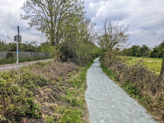 |
| North Mymms footpath 9 heading S alongside Station Road |
3: Continue along this footpath for 580m until you reach a bridge crossing a brook (location -
https://w3w.co/forces.object.damp), see images below. The brook is often dry, but can be flooded after heavy rain.
 |
| North Mymms footpath 9 approaching the footbridge |
 |
| Cross the footbridge then turns right |
Immediately after the bridge turn right through a gate then take North Mymms footpath 11 and head W with the brook on the right and the field on the left, see image below.
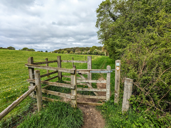 |
| North Mymms footpath 11 heading W |
Follow North Mymms footpath 11 for 300m until you reach the end of the field (location -
https://w3w.co/sides.match.salad). At the corner of the field you will see a stile on your right leading to a bridge crossing the same brook, see image below.
 |
| The second bridge over the brook |
4: Cross this bridge then, once on the other side, look out for a footpath gate on your left (location -
https://w3w.co/refers.change.driver).
Go through this gate then continue, still on North Mymms footpath 11 which is also called Wises Lane along this stretch. Continue through Brick Kiln Wood with the brook running on your left for 580m. This path has a great display of bluebells in the spring, see image below. The path soon opens out with fields on your right.
 |
| Bluebells along North Mymms footpath 11 (Wises Lane) |
Keep the hedge and brook to your left and continue. Ignore the first footpath on your left (location -
https://w3w.co/sooner.varieties.theme) and continue heading W until the path swings to the left along an elevated wooden walkway (location -
https://w3w.co/plug.preoccupied.guard), see image below.
 |
| Continue along the wooden walkway to a concrete footbridge |
Continue along the wooden walkway to a concrete footbridge over Mimmshall Brook (location -
https://w3w.co/pads.rather.eating), see image below. Cross the bridge to reach Warrengate Road.
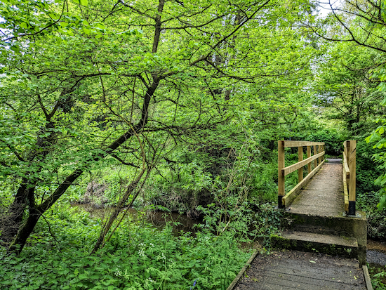 |
| The footbridge over Mimmshall Brook |
5: Turn right on Warrengate Road and walk N to the hamlet of Water End. After 580m you will reach
The Woodman Inn on your right, see image below.
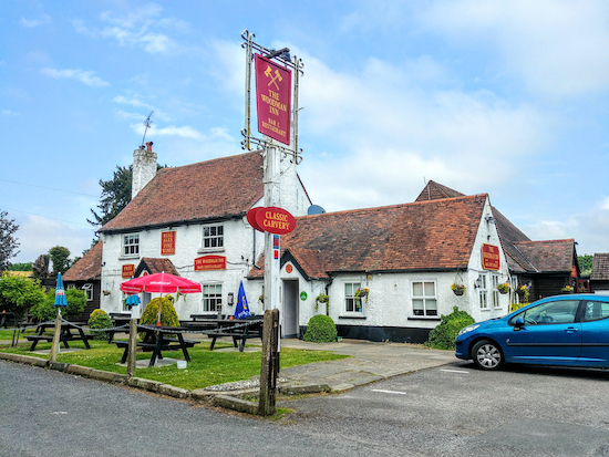 |
| The Woodman Inn, Water End |
6: Continue walking NNW past The Woodman Inn until you reach Swanland Road (location -
https://w3w.co/that.debate.smile).
7: Here you turn right then walk N along the cycle path and footpath past the garages following the path for 190m ignoring the first footpath on the right (location -
https://w3w.co/soaks.retain.public) and continuing until you reach the second footpath on the right, North Mymms footpath 30 (location -
https://w3w.co/total.power.hopes), see image below.
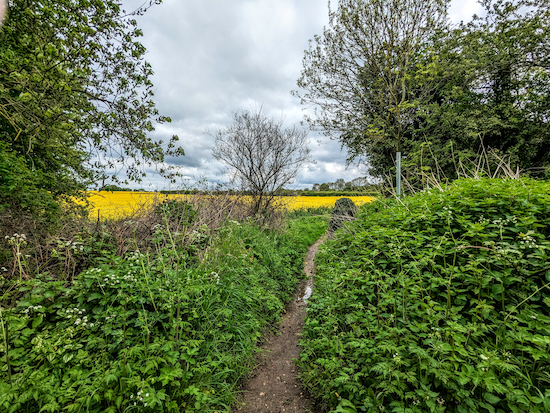 |
| Turn right on North Mymms footpath 30 |
8: Turn right on this footpath then head E for 85m keeping the hedge on your right and the field on your left until you reach a footpath that crosses (location -
https://w3w.co/thus.wisdom.joke). Continue heading E for 110m until you reach the corner of the field, see image below.
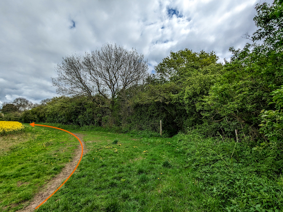 |
| Turn left at the marker post where the path swings to the left |
9: Turn left then continue to follow the path NE for 70m with the fields on your left and hedgerow on the right until you reach another way marker and a footpath to your right (location -
https://w3w.co/wipe.loops.rubble), see image below.
 |
| Turn right, still on still North Mymms footpath 30 |
10: Take this path, still North Mymms footpath 30, then follow it through the hedgerow and woodland, cross a bridge over a stream, see image below.
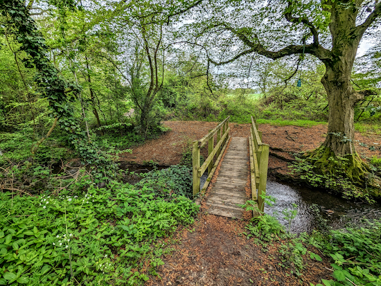 |
| Turn left after crossing the footbridge |
Once over the stream turn left then head NE until you reach a field (location -
https://w3w.co/hopes.lazy.pure), see image below.
* At this point many walkers turn left and follow the edge of the field first ENE then SSE, keeping the field on the right and the hedgerow on the left, for 890m to reach Bradmore Lane, but this is not a public right of way, see map of detour below.
 |
| Unofficial detour marked in orange |
11: Turn right at the field, then, keeping the hedge on your right and the fields on your left, head S for 210m until you reach a footpath junction (location -
https://w3w.co/mental.calculating.labels), see image below.
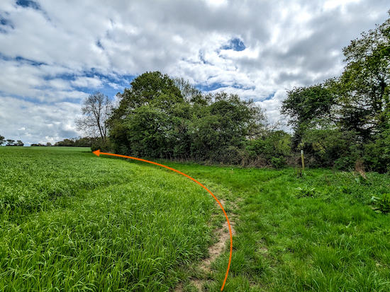 |
| Turn left on North Mymms footpath 7 |
12: Turn left on North Mymms footpath 7 then head E for 95m with the hedgerow on the right and the field on the left until the path bends right (location -
https://w3w.co/spins.faded.valley), see image below.
 |
| Turn right on North Mymms footpath 8 |
13: At this point North Mymms footpath 7 should continue heading E across an arable field, however it is seldom reinstated after ploughing and sowing. Because of this, walkers often turn right then head SSE, with the hedgerow on the right and field on the left, and continue, now on North Mymms footpath 8 for 160m until the footpath bends right then left to cut through the hedgerow and reach Bradmore Lane (location -
https://w3w.co/deal.bliss.green), see image below.
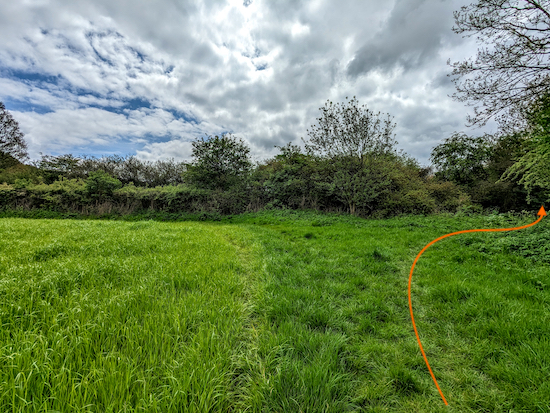 |
| At the corner of the field the footpath bends right then left |
14: Turn left on Bradmore Lane then follow the lane E for 830m to Station Road (location -
https://w3w.co/splash.custom.cages).
15: Turn right on Station Road then head S for 250m to return to Brookmans Park Station.


Tried this walk as an excuse to have lunch at The Woodman
ReplyDeleteInn again! As we have dogs, there was a bit too much walking on narrow lanes without footpaths but the fields and wooded areas were very quiet
Hi Orla, yes, that walk does involve quite a bit of lane walking. Sorry about that. We probably passed you at some point because we walked some of that route in reverse today and stopped for a drink at The Woodman Water End on the way back. David
DeleteHi Orla, I have added a line to the walk directions which reads: "About a third of the walk is along lanes so if you have dogs or children you might want to pick another route." Thanks for the feedback. David
ReplyDelete