1.8 miles (2.9 km) with 27m of total ascent
 |
| The footpath between points 9 & 10 |
This is a lovely short walk for the summer months when the fields at Radwell Meadows Country Park are ablaze with wildflowers, and butterflies follow you along the footpaths. It's ideal for those who like shorter walks with minimal up and down. The route loops through the meadows in the
River Ivel valley crossing the river twice.
 |
| The play area for children close to the car park |
There is a play area for children close to the car park, so it might be a good place to visit during the summer holidays for a short nature walk and a play.
There is a car park at the start/finish point. When we tested this walk in July 2024 it was firm underfoot, but it looks as though it could get muddy and perhaps flood in parts after heavy rain.
There is a mobile cafe at Radwell Mill but it was closed when we visited.
The Three Horseshoes is 750m SW of the start/finish point.
 |
| 'Please keep dogs on lead' sign |
There are several notices along the way asking dog owners to keep their pets on a lead.
Fly through preview of walk
If you want to check what sort of landscape you will be crossing before you set off on this walk you can view a short 3D video of the route below. It's created using the free version of
Relive.
Directions
 |
Map for Walk 273: Radwell Meadows East Loop
Click on the map above for a larger version
Created on Map Hub by Hertfordshire Walker
Elements © Thunderforest © OpenStreetMap contributors
There is an interactive map below these directions |
Those with GPS devices can download
GPX or
KML files for this walk. We've added
What3Words location references for those who use that system. If you print these walks you might want to use the green
PrintFriendly icon at the bottom of these directions to delete elements such as photographs.
1: From the car park at Radwell Meadows Country Park (location -
https://w3w.co/level.always.wells) head SE (back towards the vehicle entrance) then take the footpath on the left (location -
https://w3w.co/crowds.react.necks) before you reach Norton Bury Lane, see image below.
 |
| Turn left on Letchworth Garden City footpath 30 |
Turn left on Letchworth Garden City footpath 30 then head N and diagonally across a meadow for 365m until you reach a gate leading to a junction (location -
https://w3w.co/thickened.shield.robe), see image below.
 |
| Go through the gate then turn left |
2: Go through the gate then turn left, still on Letchworth Garden City footpath 30, then cross a wooden footbridge to reach another gate (location -
https://w3w.co/broadcast.admiral.woods), see image below.
 |
| Cross the wooden footbridge to reach a gate |
Go through the second gate then head WNW with the hedgerow on the right for 80m until you cross a meadow footbridge (location -
https://w3w.co/colleague.gently.guests), see image below.
 |
| Cross the footbridge, still on Letchworth Garden City footpath 30 |
Cross the meadow footbridge, still on Letchworth Garden City footpath 30, then continue heading WNW for 115m to another meadow footbridge (location -
https://w3w.co/basically.tower.splashes), see image below.
 |
Cross the footbridge still heading WNW
|
Cross the second meadow footbridge then continue heading WNW, still on Letchworth Garden City footpath 30. Continue for 300m to a wooden footbridge and a gate leading to a junction (location -
https://w3w.co/occupations.kitten.sings), see image below.
 |
| Cross the footbridge then go through the gate |
3: Cross the footbridge, go through the gate, then keep right. Continue heading WNW, still on Letchworth Garden City footpath 30, and with the hedgerow on the right and meadow on the left, for 275m to a junction (location -
https://w3w.co/catapult.closes.rarely), see image below.
 |
| Turn right through a gate |
4: Turn right through a gate. (The gate in the image above will no doubt be replaced soon, so don't be surprised to find a new aluminium gate where the old wooden one above currently stands). This area looks as though it could get muddy after rain.
Once through the gate head NE on Radwell footpath 9 for 115m until you reach a mobile cafe on the left (location -
https://w3w.co/alike.scorecard.treble).
 |
| Radwell Mill mobile cafe |
This cafe, which probably serves the nearby campsite, was closed when we walked this way on a Thursday in July. There is a sign in the car park at the start of the walk advertising its services. Perhaps it's open at weekends and holidays; I couldn't find a web address or phone number to check.
 |
| Continue heading NE now on Radwell footpath 7 |
5: Continue heading NE now on Radwell footpath 7. Cross a footbridge then continue through woodland for 115m until you reach Radwell Lane and Radwell Lake (location -
https://w3w.co/elbowing.organic.charities), see image below.
 |
| Radwell Lake |
6: Turn right on Radwell Lane then head ENE for 250m until you pass the Church of All Saints on the left - a
Grade II* listed building (location -
https://w3w.co/newlywed.crunching.streamers), see image below.
 |
| The Church of All Saints Radwell |
7: Continue heading ENE along Radwell Lane for 65m until you reach a footpath on the right (location -
https://w3w.co/type.doormat.deeds), see image below.
.jpeg) |
| Turn right on Radwell footpath 8 |
8: Turn right on Radwell footpath 8 then head SE for 155m through a farmyard until you reach a right-hand bend (location -
https://w3w.co/tycoons.diets.coveted), see image below.
 |
| Turn right on Radwell footpath 2 |
9: Turn right on Radwell footpath 2 then head SW for 215m to a bend (location -
https://w3w.co/heartless.bookcases.spans), see image below.
 |
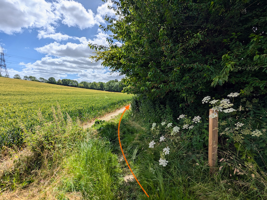
| Keep left at the bend then head SE on Radwell footpath 5 |
10: Keep left at the bend then head SE on Radwell footpath 5 for 120m until you reach a junction (location -
https://w3w.co/dandelions.shuffles.gathering), see image below.
 |
| Turn right on Radwell footpath 3 |
11: Turn right on Radwell footpath 3 then follow it SE across a lovely wildflower meadow for 155m until you reach a junction (location -
https://w3w.co/workshop.tumble.punctured).
12: Turn left on Radwell footpath 4 then head SE, with the hedgerow and River Ivel on the right and meadows on the left, for 260m until you reach a junction (location -
https://w3w.co/skimmers.codes.cheeks), see image below.
 |
| Turn right on Radwell footpath 5 |
13: Turn right on Radwell footpath 5 then head SE for 90m until you reach Norton Bury Lane (location -
https://w3w.co/waltzes.writing.animate), see image below.
 |
| Turn right on Norton Bury Lane |
14: Turn right on Norton Bury Lane. There isn't a pedestrian pavement along Norton Bury Lane but there are verges where you can step aside if traffic approaches. Head SW for 90m until you reach Norton Bury Mill on the left (location -
https://w3w.co/fizzled.indulges.initiated), see image below.
.jpeg "Looking back to Norton Bury Mill") |
| Looking back to Norton Bury Mill |
15: Continue heading SW along Norton Bury Lane for 265m until you return to the car park.
If you enjoyed this walk please consider joining our
Hertfordshire Walker members-only Facebook Group where you can share photos and comments on your walking experiences.
Interactive map


.jpeg)


.jpeg "Looking back to Norton Bury Mill")


No comments:
Post a Comment
Comments and feedback
If you try any of the walks on this site, please let us know what you thought of them. You can either comment here, or on our members-only Facebook Group where walkers are sharing photographs of their walks and walking tips. Comments on our Facebook Group go live immediately, as they do on our Facebook Page. Comments here on our website are moderated, so there will be a slight delay before what you write goes live.